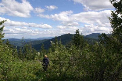
Solitude, great views await you on Scout Trail

This trail for the hardy hiker is unique.
Part of the Farragut State Park trail system, it leads across private land – thanks to a gracious private landowner to the site of a former fire lookout tower. The length and incline requires users to be in good physical condition for this day hike, but the solitude and views along the way and from the top of the 5,000-foot plus Bernard Peak make it worth the effort.
The north access, through Farragut State Park, connects to the Scout Trail through a series of trails, and then it’s a strenuous hike to the summit. The south access, off Bunco Road, offers an all-downhill descent to Farragut, but remember, unless you have transportation waiting for you at the bottom, “what goes down must come back up.”
North access: From the intersection of I-90 and U.S. Highway 95, go north on U.S. 95 for 18.3 miles, turn right on Highway 54, then follow the signs to the park. Stop at park headquarters for a trail map and more information and pay the parking fee. Turn right just past headquarters on South Road and drive 1/4 mile to the trailhead on the right. Trails 42, 45, 67 and 68 provide a narrow path through boulders and connect to the Scout Trail at trail marker 97. Continue eastbound through the logged area to the trail. Don’t take any southbound roads.
South access: From the intersection of I-90 and U.S. 95, go north on U.S. 95 for 16.7 miles, turning right on Bunco Road. After 2.4 miles, turn left to continue on Bunco. Go approximately 4.7 miles on Bunco where the pavement ends and becomes Forest Road 2707. Go 4.5 miles on 2707 to a left on 2708, then .4 miles to Bernard Peak. The last 5 miles of this trip is on a narrow, rocky mountain road and is recommended for vehicles with adequate clearance (4-wheel-drive preferred).
Length: Approximately 16 miles round trip.
Elevation: From the trailhead in Farragut Park, it is a 2,750-foot climb to the summit at Bernard Peak at 5,154 feet above sea level.
Use: Light.
Trail condition: Mostly well-packed trails with narrow and steep portions in the rock cliffs and considerable loose rock. There is good signage on the trail for the first 2.5 miles from Farragut State Park, then scarce to none.
Difficulty: Moderate.
Restrictions: No motorized vehicles on the trail, no littering, no fires or camping on private land. Please show respect to the private landowner to ensure future use of the trail. There is a $4 parking fee in Farragut State Park.
What to see: Great views over Lake Pend Oreille. This beautiful forest provides excellent wildlife habitat, so watch for both small and big critters.
Special features: Camping in Farragut State Park, boating and fishing in the lake. There is a Geocache (the treasure hunt game, using clues from the Web site, www.geocaching.com) near Bernard Peak.
Preparation: A trail guide is available at the Farragut State Park headquarters and Visitor Center (208-683-2425). Visit the park Web site at http://www.idahoparks.org/parks/farragut.aspx. The ranger office suggests leaving your trip schedule with a responsible person. Detailed topographical maps are available for purchase from the following vendors in Coeur d’Alene: Black Sheep Sporting Goods, The Yacht Club Sales and Service and North Idaho Blueprint.
Gear: Good hiking boots are essential and hikers should dress for changing conditions and carry drinking water and a first aid kit.
Note: Originally established in 1967 and named the Bernard Peak Trail, the trail was closed due to a lack of public access over private lands. The Richards family from Hayden Lake donated land to connect the trail from Farragut State Park to Bernard Peak and in 2002, the trail was re-established as a volunteer project for the Boy Scouts and the reblazed trail got its name. The fire watch spot was active from 1918 to 1976, when the tower was removed.