Map to riches
In the 1930s, a young geologist named Arthur Sorenson mapped the Star Mine in Idaho’s Silver Valley, recording his findings on linen paper. The result was page after page of meticulous drawings, each showing different levels of the 8,000-foot mine.
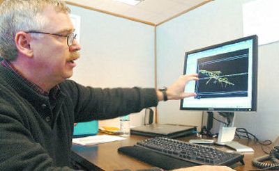
“What the geologist had to work with in the past was these flat maps,” said Art Smith, a geologist at Hecla Mining Co., gently handling the yellowing pages.
But nowadays, Smith can pull up a three-dimensional model of the historic Star Mine — which operated from 1890 to 1982 — on his computer screen, showing its ore body, tunnels and mineral intercepts. He can also study the mine’s geographic relationship to three nearby silver deposits.
The computer models are part of a $500,000 effort to digitize a century’s worth of geological data stored in Hecla’s basement.
Maps such as Sorenson’s are scanned, then emailed to India, where technology workers convert the drawings into digital form. The maps are emailed back to Hecla, where Smith and other geologists use them to build detailed computer models.
The work is more than a scholarly exercise. With silver trading at more than $13 per ounce, the Coeur d’Alene-based company wants to explore 40 square miles of holdings in the Silver Valley for new silver-lead deposits. The modeling will help the company target where to drill.
The work is exciting for the region, said Earl Bennett, the retired dean of University of Idaho’s former School of Mines. Hecla isn’t the first to create computerized models of its mines, but it’s the first to tackle such a large area in North Idaho, he said.
“There’s never been a geologist who worked in the Coeur d’Alene District who doesn’t think there’s a lot more minerals there. That’s been true since 1884,” Bennett said.
The area Hecla plans to explore produced more than 300 million ounces of silver – rivaling Nevada’s famed Comstock Lode, said Phil Baker, Hecla’s president and chief executive officer. “And down in our basement, there’s an amazing supply of archives and file cabinets with maps and reports dating back to the 1890s.”
In recent years, the material gathered dust while Hecla looked for silver and gold deposits in Latin America, where operating costs are cheaper. Low-cost properties kept the company solvent when silver prices sank below $5 per ounce, Baker said.
Now silver prices are on the upswing, driven by higher worldwide demand for metals, and Hecla’s ready to explore again in the Silver Valley, he said. It costs more to pursue the deep, underground mines characteristic of North Idaho. But the mines also tend to be extremely long-lived, Baker noted. Hecla’s Lucky Friday Mine in Mullan, Idaho, has been producing silver since the 1950s.With the new technology, Hecla will be able to take a closer look at the ground that produced the Hercules, the Tamarack, and other storied Idaho mines. The region’s mineral wealth helped build Spokane during the early 1900s, but also left a Superfund legacy of heavy metals contamination. If a new mine were built today, it would have to pass stringent environmental reviews, Baker said.
Not all of the historic mines that Hecla is creating models of were operated by the company. Some of the records ended up in Hecla’s basement through later mergers.
“Part of the process is a lot of fun because looking over the records is like going back in time,” said Dean McDonald, Hecla’s vice president of operations.
Geologists got a laugh from a 1950s report about the Lottie L, several small mining claims that Hecla wanted to buy at one point. The owner lived in Montana. “Get there before 10 a.m. to talk it over with her, because after 10 she’s taken to the bottle,” the report advised.
More importantly for Hecla’s purposes, the records are clues to the presence of other deposits, Baker said. “It’s like putting a jigsaw together, except there are lots and lots of pieces,” he said.
When the computer work is done, Hecla will have 3-D models of about a dozen former mines in Eastern Shoshone County, plus smaller workings scattered throughout the area. Many claims were explored near the surface, and abandoned when the owners ran out of money to do deeper drilling.
“There’s a lot of science used in determining where to drill now,” Bennett added. “It’s not just gut feeling anymore.”
Through the computer modeling, Smith, the geologist, will be able to picture the shape of mines he’s never been in. In large underground operations, the tunnel systems and the ore bodies are so complex that geologists usually require several years of familiarity with a property to fully visualize it.
Smith often thinks about Arthur Sorenson as he manipulates mine models on his computer screen. Sorenson was a prolific geologist, who name appears on 40 years worth of maps and reports. On his maps of the Star Mine, the silver veins are colored red and faults appear in blue — details faithfully captured by workers in India.
Smith’s models depend on the work of those early geologists, who did their mapping long before tools like global position systems were invented.
“They were fine draftsmen,” he said.
Becky Kramer can be reached at (208) 765-7122, or by email at beckyk@spokesman.