‘Transformative’ renovations on the way for section of Fort George Wright Drive
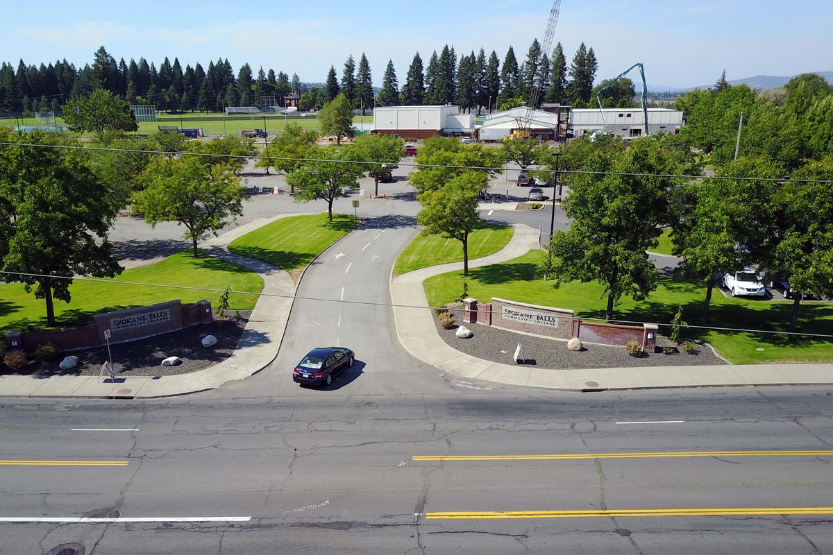
For the span of just a few hours each year, it’s safe to stroll along Fort George Wright Drive near Spokane Falls Community College. Just you and 50,000 other people on the first Sunday in May.
Other than on Bloomsday, however, walking along the four-lane arterial is a bit sketchy.
A new plan for the street seeks to change that.
Instead of four lanes of traffic along a street lined with a few trees and utility poles, the arterial would have two lanes, townhomes, restaurants, bike lanes, a treed median and traffic lights. Planners envision an urban, walkable development in place of a motorist’s thoroughfare.
The plan is lauded by supporters as collaborative and transformative, and the first step to realization was funded earlier this year by the state Legislature. Still, the rest is far from certain, with concerns about a loss of parking on the college campus and a loss of view caused by new buildings still unaddressed.
Developed by the Spokane Transit Authority and the West Hills neighborhood, the plan seeks to capture the momentum in development that has happened near the campus over the last decade. River Run, a housing subdivision, began construction in 2005 and has built dozens of homes, but has yet to fulfill its original vision of raising commercial buildings as well as multiple housing types beyond the single-family home.
Last year, the nearby Sisters of the Holy Names property sold to Catholic Charities, which is quickly building hundreds of units of transitional and low-income housing on the land.
Despite population growth in the area, there was nothing for them to do, said Bridget Walden, chair of the West Hills neighborhood.
“There’s nothing there out there,” Walden said.
Nothing but increased traffic, which the transit agency saw as potential riders.
The transit agency kick-started the plan process in 2015, when it approached the neighborhood about combining the $21,000 West Hills had for neighborhood planning funds with $60,000 in transit planning money to develop a walkable, mixed-use neighborhood center, calling for what amounts to a new city center in what is currently a parking lot on SFCC’s campus.
This spring, the transit agency was awarded $2.1 million in mobility grants, state transportation money intended to improve local transit and reduce congestion on heavily trafficked roads. The grant money will build a transit station and bus shelters on campus, and a new traffic signal at Fort George Wright and Elliott Drive, allowing buses to load and unload passengers away from the busy road, which it currently uses.
Construction on the station is expected to begin and be completed in 2019.
Darren Pitcher, president of SFCC, said he welcomed the new station simply out of safety’s sake, but wasn’t yet convinced of the need for a “mini-Main street” on campus.
“We had a couple incidents where kids were hit by cars” while crossing Fort George Wright from the bus stop on the south side of the street, Pitcher said. “We just couldn’t go along with that anymore.”
Pitcher said that while SFCC “is supportive of the improvements, and very vested in the future of the neighborhood,” it hasn’t signed off on the complete plan yet, primarily due to the parking the college loses in the document. The school’s parking lots are completely full the first two weeks of every quarter, when 5,000 students are buying books and raring to go, Pitcher said. Even with a subsidized, $22 bus pass that lasts the entire quarter, many students still drive.
“I’m not sure I’m willing to give up parking lots for coffee shops,” Pitcher said.
Walden, who lives on Sunset Hill, also has concerns. She helped develop the plan and supports it, but said the discussion is far from over.
The West Hills neighborhood sees the street as “a place that can be a destination,” Walden said, and wants it to be part of a “loop” with Kendall Yards, the Centennial Trail and the Sandifur Bridge.
But she added that motorists who frequent the road are worried about losing two vehicular lanes. And she pointed to the townhomes outlined in the plan running on the southern side of Fort George Wright Drive. Walden said neighbors are concerned about losing views of downtown if the units are built too tall or too close together.
“It’s their space and if they want to they can,” Walden said ruefully of the developers of River Run, who could not be reached for comment.
Kathleen Weinland, a planner at STA who helped in the plan’s creation, said its details are far from complete. At the very least, the city needs to approve land use zoning changes and encourage private development.
“Further agreement needs to happen,” she said.
She added that all the elements of the plan are connected with the same goal of encouraging transit ridership and anchoring a large neighborhood that has no center.
“Every transit customer starts out as a pedestrian, so improving Fort George Wright is crucial,” Weinland said. “This new development will lead to new ridership.”
Even without complete agreement on the plan, SFCC’s Pitcher said the growth near campus has been difficult to keep up with. So fast, he said, the community college must update its own master plan to keep up. He pointed to the traffic signals being built on either end of Elliott Drive, by STA and where the Catholic Charities housing is going up.
“In two years, we’re going to have two traffic lights,” he said, noting that earlier this year, administrators were wondering how they were going to handle the increased traffic and safety concerns. “Six months ago we were saying, ‘What are we going to do?’ ”