Spokane’s future plan resurrects Ferris High School road, creates preference for some street work
A document that will guide Spokane’s growth and development years after all the current occupants of City Hall have moved on is up for a vote next week, amid lingering concerns about streets and a long-gestating road project that would cut through the grounds of Ferris High School.
The Spokane City Council took testimony from neighborhood representatives and others Monday about proposed changes to the city’s Comprehensive Plan, a document first approved in 2001 that hasn’t seen a full update in more than a decade.
“It is constantly a work in progress, obviously because we’re trying to deal with growth that’s happening within our community in a way that still honors the community’s vision for itself,” said Lisa Key, the city’s planning director.
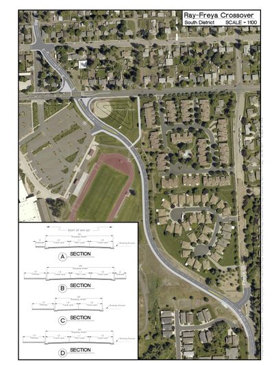
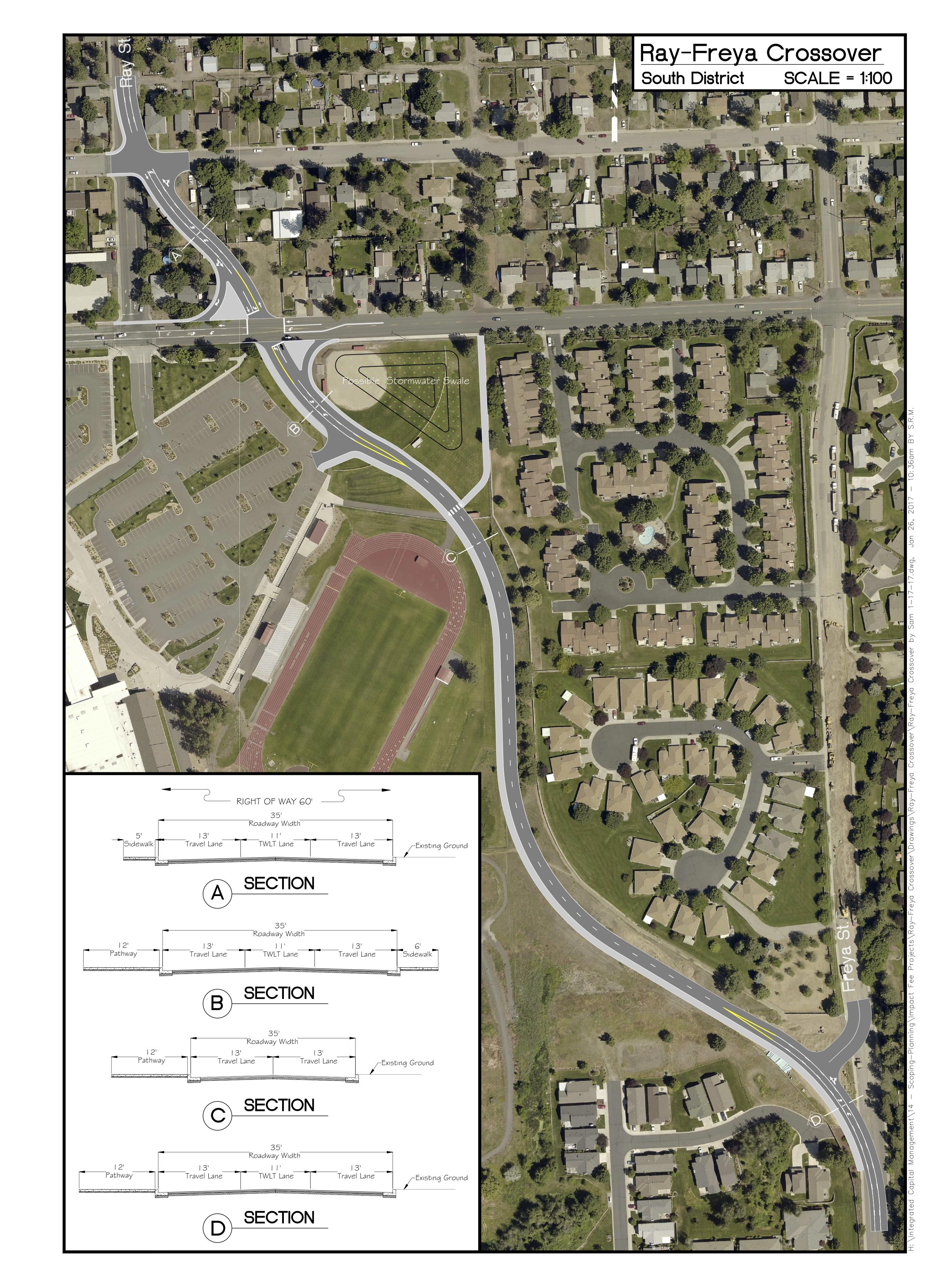
The draft plan includes a way to allow certain road projects to bypass others waiting in line for public money if they’re in areas the city has deemed important for economic development, drawing skepticism from some neighborhood planners. It also resurrects the so-called Ray-Freya crossover, a $4 million road project intended to alleviate traffic congestion on the South Hill that has existed in some city planning documents since the 1960s but has drawn opposition from the surrounding neighborhood, who says stoplights are sufficient.
Jumping in line?
When the city needs to decide which roads to rebuild, planners look at a prioritized list that includes the need to ease traffic congestion, repair utility lines and increase services for pedestrians and public transit users.
A proposal in the new comprehensive plan would allow the City Council to declare an entry on the list a “project of significance” and move it ahead in line. Construction would also address “only the most pressing transportation elements first,” a provision groups such as Futurewise, a nonprofit that seeks to limit urban sprawl, say could lead to half-finished streets that don’t include sidewalks and other amenities, as required in a 2011 city law.
“This city is so desperate for industrial development, they would do almost anything to get it, but at what cost to the neighborhoods, and the future workers at that site?” said Kitty Klitzke, program director for Futurewise Spokane.
Discussion Monday night included potentially moving up reconstruction of Freya Street between Garland and Francis avenues, a $4.2 million project the city hopes to build by 2023, partially using grant money obtained through the Freight Mobility Strategic Investment Board, a state agency promoting the movement of goods by land, sea and air. The project sits at 32nd on a list of 79 projects slated for construction in the next 20 years.
City Councilwoman Candace Mumm proposed a change that she hopes will limit the number of projects that can jump in line. The new proposal states such projects “should” be considered one-at-a-time in the city’s six-year outlook on new road construction.
“I am in full support of complete streets. I also recognize that we have some unusual situations that need to be phased in, such as Freya,” Mumm said Tuesday.
But Klitzke said the proposed change likely wouldn’t stand up to legal scrutiny, and that the pressure from developers to get their road projects moved up on the list might become too great for future city councils to ignore.
“I understand the need for some kind of flexibility if there’s a super important project, but every developer believes their project is a super important, game-changing project,” she said.
City Councilman Mike Fagan said a project of significance designation would allow developers to make their case to city officials and potentially fast-track projects that could otherwise be bogged down by the costs of a full build-out in parts of town that might not make sense.
“To me, it all boils down to, you say you’ve got a project of significance that can drive some economic development, sit down and talk to me about it,” Fagan said. “Sell your concept to me.”
Mumm said she believed the proposed changes addressed the concerns brought by Futurewise and other groups by narrowing the ability for projects to be named significant, and that the plan leaves open the possibility other transportation features, such as walking trails, bike lanes and transit routes, could also be designated significant and moved ahead in line.
The crossover returns
Since 1966, road planners at the city of Spokane have been suggesting a way to link Ray and Freya streets, providing an unencumbered north/south route from the South Hill to Interstate 90.
Those plans have always cut through Ferris High School, but the surrounding neighborhood has urged city planners to consider other options to ease congestion on Regal Street, including stoplights at several intersections.
Regal Street has been designated a neighborhood center, and traffic should move slower along that route, said Ted Teske, chairman of the Southgate Neighborhood Council.
“People are complaining about slow traffic on Regal, but that’s by design,” said Teske. “It’s one piece of a big puzzle up there.”
The Southgate Neighborhood wrote the proposed connector out of its neighborhood plan, which was adopted by the Spokane City Council in 2012. However, the comprehensive plan put the so-called crossover on the long-term list of roads to build, prompting the neighborhood to urge the City Council to excise it from the comprehensive plan. Teske said its inclusion gives “a toehold” for the project to be built against the wishes of the neighborhood.
Spokane Public Schools have adopted the road as part of their own long-term master plan, said Mark Anderson, the district’s associate superintendent in charge of school support services.
“We can go either way,” Anderson said. “We’re well positioned, whatever decision they make.”
The school would weigh in on the design of the road, if and when the city moves forward with construction, Anderson said.
The City Council successfully moved Monday night to revise the plan to call for construction of a traffic-calming measure that emerges as the choice of both the city and the neighborhood, but didn’t eliminate the possibility of building the road.
“It’s still in the plan and the map, and the project list,” Teske said.
What’s next
Requested changes to the draft comprehensive plan are expected to be posted online Wednesday morning, said Key, the city’s planning director, ahead of a hearing Monday night whether to formally adopt the document in its entirety.
It will be the first time the City of Spokane has completely overhauled its comprehensive plan since 2006, Key said, and end a process that was begun in 2013.
Klitzke joked that she was pregnant when discussion of the update first began; she’ll watch her daughter turn four later this month.
“I don’t feel like this process was ever contentious. I feel like the ball was dropped and picked up by so many different people,” she said.
Key acknowledged that there have been some fits and starts in developing the plan, but hoped the final document would be something city residents would feel invested in after four years of discussions.
“It’s the policies that really drive decision-making in our city, and it’s more than land use, economic development, parks and open space,” Key said. “It’s really how the city provides services to its citizenry, and how we implement the vision that the community has established for ourselves.”