Getting There: Spokane mulls reducing lanes on Grand Boulevard in 2027
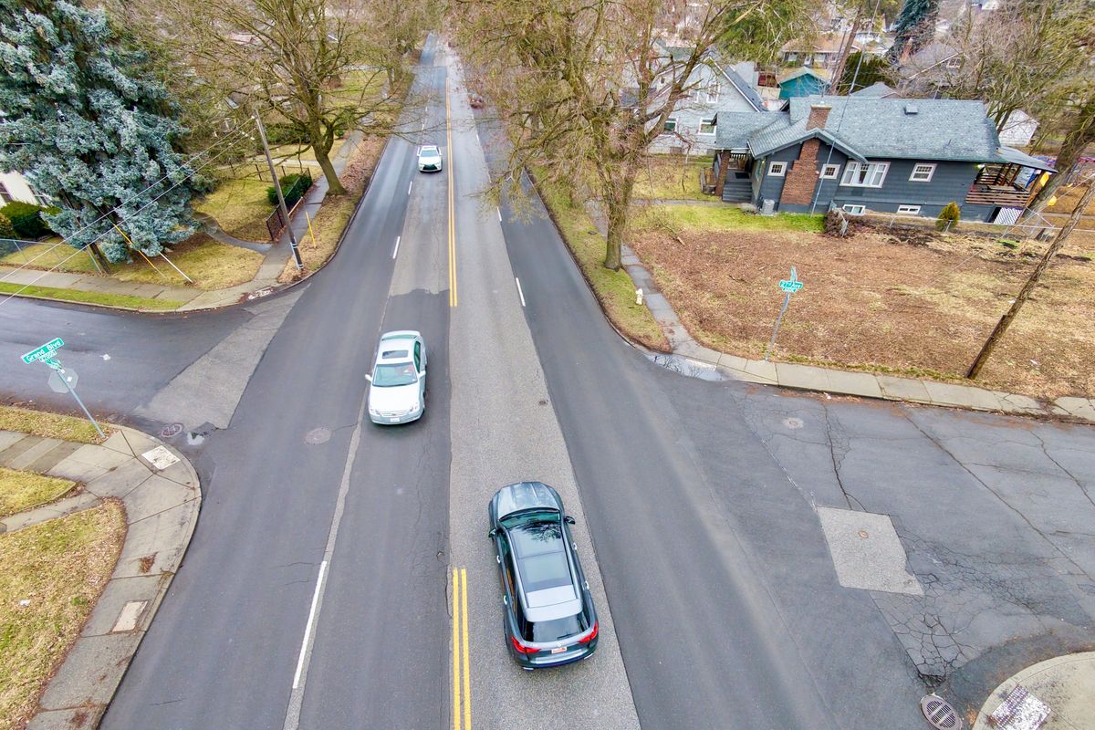
Most of the northern half of Grand Boulevard, a major arterial connecting the southern half of Spokane to its downtown, will likely lose at least one lane for through traffic next year in a move city officials believe will reduce crashes by up to 24%.
Two southbound and two northbound lanes on the street currently run from the Sacred Heart Medical Center to roughly 32nd Avenue. The city’s Transportation Commission will choose between two options for restriping the street between 14th and 29th avenues, either of which would convert a lane for through traffic into a turn lane and one of which would eliminate a second lane entirely.
In either case, some kind of enhanced, flashing crosswalk will also be installed across Grand Boulevard at 27th Avenue. In no case would the city add a bike lane to the street due to limited space even if a vehicle lane was removed.
“I looked at how to implement some type of bike lane … could we have a striped bike lane going uphill and a shared bike lane going downhill, but it’s too high of a level of stress,” said Brian Brisendine, a city streets engineer, at a December meeting of the Transportation Commission. “We would want to provide something more substantial.”
The corridor is one of Spokane’s busiest, with an average of at least 14,000 vehicles passing along its length each day, and city officials believe restriping the road would eliminate a significant portion of its crashes.
Without a turn lane, vehicles on Grand Boulevard attempting to turn left frequently have to come to a complete stop in a through lane. In addition, the lack of a turn lane or something separating oncoming traffic allows for more sideswiping accidents. Of the 42 reported crashes along this stretch from 2020 to 2024, officials estimate eight could have been prevented with a separated turn lane.
Eliminating another lane would also make it easier to turn left onto Grand Boulevard, according to engineers’ estimates, as well as reducing the possibility for adjacent traffic headed in the same direction from sideswiping each other. Combined with a dedicated turn lane, 10 of the 42 crashes between 2020 and 2024, or about 24%, reportedly could have been avoided by these modifications.
Road diets, as it is often called when cities reduce travel lanes, have proven more controversial for residents than for engineers, however. For many who travel down the corridor regularly, the reduction in accidents is not necessarily worth the estimated 30-60 seconds of extra travel time on their daily commute. Others worried that traffic from Grand would get diverted onto other north-south streets.
City officials heard these concerns at a rowdy public meeting held Jan. 27 at St. Mark’s Lutheran Church, with one engineer responding to the criticism by suggesting that the city could decide to leave the roadway as it is.
For residents living along Grand Boulevard, this dialogue proved frustrating. At one point, a woman asked how many in attendance lived on the street; of the roughly 100 people in attendance, around 10 reportedly raised their hands.
“For those of us who live here, we want things to slow down,” said Mary Winkes, interim chair of the Manito/Cannon Hill Neighborhood Council.
That neighborhood has worked for years to slow down traffic on the numerous north-south arterials cutting across it and recommended traffic calming measures on Grand five years ago, Winkes said.
Speeding is frequent, particularly headed downhill, she added. Coming home from a concert on Labor Day weekend, Winkes said she passed by a crash at Grand and 17th Avenue where someone had driven over a street sign and collided with a telephone pole.
“So tell me how fast they were coming down Grand?” she asked. “That can happen, especially on the downhill.”
Winkes argued that the city should also be installing speeding cameras along Grand, particularly near the parks, which issue tickets if someone is driving at least 8 mph over the speed limit. While ticket-issuing speeding cameras near parks had been a priority for the Spokane City Council three years ago, the city has since pivoted to prioritizing red-light cameras near its most dangerous intersections, citing a lack of administrative capacity to expand both at this time.
It can also be dangerous to cross the street, noted Bill Doley, chair of the Rockwood Neighborhood Council and representative on the Community Assembly.
Along with restriping, the city is considering building concrete “refuge islands” for pedestrians in the middle of Grand, likely at the intersections with 19th, 20th, 21st and 27th avenues. In addition to reducing through lanes, city engineers hope the additions will make it safer for pedestrians to cross the busy road.
While both Doley and Winkes expressed support for some of the changes being proposed, they also voiced frustration that the city has continued to deprioritize the input of neighborhood councils in decisions about traffic calming measures.
“The city used to do traffic calming directly with neighborhoods,” Doley said. “Then they got consultants involved, and now nobody listens to us.”
Winkes noted that she hadn’t heard about the specifics of the proposal until just a few days before the public meeting at the church. At least one neighborhood council, Comstock, won’t meet again before the Feb. 18th vote by the Transportation Commission, preventing the group from providing formal input to the body, she added.
When the decision is made, she said she hopes that the city weighs the priorities of those living along the street over those who just drive through it on their way to something else.