‘Pick a direction and start heading up’: If only it was that simple to snowshoe to the top of Mount Spokane
If you take anything away from the following tale, I hope it is this: Anyone, even a pair of unskilled snowshoers qualifying for Social Security, can successfully make it all the way to the top of Mount Spokane, elevation 5,883 feet.
However, I fear your takeaway might also be this: It is entirely possible to get lost trying to snowshoe to the top of Mount Spokane, despite the fact that you simply have to POINT YOURSELF UPHILL.
The expedition took place on Jan. 28, as Rick Bonino and I embarked on the monthly trek of the Bonino-Kershner Hiking and Brewpub Club (Snowshoe Edition). This club’s members consist solely of Bonino and myself, because (1) we are quite picky about our choice of company, and (2) nobody else will go with us because word has spread about how often we get lost.
We began our summit assault with an abundance of confidence. After all, we had previously completed a summertime hike to the pinnacle.
“That wasn’t so difficult, was it?” I said. “Why would doing it on snowshoes be any harder?”
“I don’t know,” mused Bonino. “Maybe because we’ll have two big awkward slabs of plastic and metal tubing attached to our feet?”
Yet we had often snowshoed the midlevel trails of Mount Spokane and had convinced ourselves that a summit push was the next logical step. On our treks to the CCC Cabin, we had often looked up at the peak and predicted that it would be “an easy hop.”
But the real reason we felt confident was that we could drive all the way to the Lower Selkirk Lodge parking lot, which is at 4,586 feet of elevation. That meant the entire trek would require only about 1,300 feet of elevation gain. Yes, I was in my 70s and Bonino would be there soon, but of course we could handle that amount of elevation.
The first part of the trek was on Trail 131 to the Bald Knob Campground, a well-trampled route through beautiful subalpine fir forests. We had done this many times before and barely broke a sweat. We were already halfway there!
And then we ran into our first problem. The official snowshoe map of Mt. Spokane State Park shows that the summit trail for snowshoers goes directly uphill from Bald Knob, arrow-straight to the peak. This was a much different route than our more-contoured summertime route. Also, we had often learned the hard way that “directly uphill” was not the strong point of the Bonino-Kershner Hiking and Brewpub Club. (Our strong point is “Brewpub”).
We looked at each other in consternation, shrugged and then plowed straight on up the trail. “Might as well follow the map,” I said. “No sense in getting lost.”
The problem was, the trail petered out as soon as we got above timberline. We stood at the edge of the trees and looked up at what might have been a few snowshoe tracks, but they fanned out in random directions. None of them were consolidated enough to resemble a packed-down trail.
Bonino and I stood and stared at these tracks for a few long moments.
“What should we do?” I said.
“I guess we just pick a direction and start heading up,” he said.
“Yes,” I said. “As long as we’re heading up, we can’t exactly get lost.”
(Note: This is what literature teachers refer to as “foreshadowing.”)
So we started plowing our way upward on the bright, sunny slope, sinking in up to our knees every so often, despite having two big awkward slabs of plastic and metal tubing attached to our feet. After about 15 minutes of hot, sweaty work, we stopped to get our bearings.
“Are we headed the right way?” asked Bonino.
“Of course,” I said, pointing up. “We just need to aim for the top.”
“Which top?” he said.
He had a point. The “top” from this angle looked like a giant dome stretched across our entire field of vision. We could not see the Vista House, or the ski lift or even the radio-TV towers. Just a lot of blinding white snow, curving ever upward, capped by empty blue sky. We could go rightward to the “top” or we could go leftward to the “top,” and I suppose we could even have gone middle-ward to the “top,” but we vetoed that idea. “Straight up,” as I mentioned above, is not our forte.
We were already winded and panting.
“I think we need to switchback up this thing,” I said, and took off leftward.
Bonino followed, but soon we were both laboriously making our own separate switchbacks. When I seemed to find a good route – meaning one moderately packed down by previous traffic – I’d wave him over. He would do the same, but none of these good routes lasted more than a few dozen steps.
At one point, I followed Bonino up to a particularly steep knoll. He was standing there looking down over the precipice
“I was just thinking that if I fell down here, I could roll a long, long way, and die,” he said.
“No, you’d be fine,” I said. “By the time you hit the trees you’d be encased in a giant snowball. Like being wrapped in a big pillow.”
I couldn’t quite read the expression on his face, but I assume it was “reassured.”
We spent another 30 minutes thrashing our way up, trending too far left the entire time, as we would later discover. We were reaching the end of our stamina, but we knew that we had no choice but to keep slogging along in a vaguely upward-by-leftward direction. I still could not see the actual summit – although I had the disconcerting impression that the bulk of Mount Spokane had somehow shifted to our right.
We were beginning to get worried. Were we ever going to reach the top? And where, by the way, was the top? Suddenly, we crested a ridge and found ourselves staring – at a road.
Or at least there was a road somewhere under a couple of yards of snow, because it was flat, and crucially, had been packed down by snowmobiles or maybe even Sno-Cats. We could snowshoe far more easily now, and were jubilant as we sauntered along it.
After a while, though, we noticed that this road wasn’t exactly taking us up the mountain. It seemed to be taking us around the mountain. What if it doesn’t go to the top? We unfurled our snowshoe map, but it showed no road at all. We knew there was a summertime Summit Road, closed in winter, but did it actually go sideways like this? (Yes, we would later discover, it does, before switchbacking a few times.)
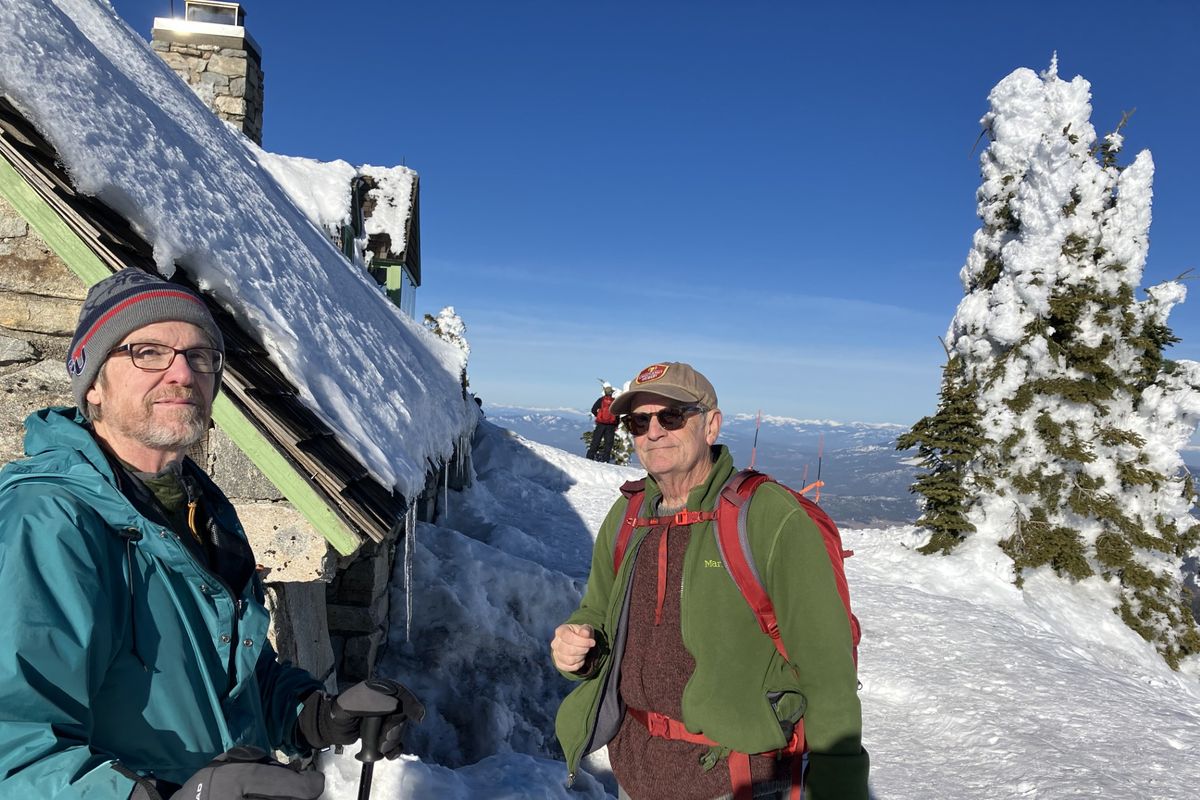
But we didn’t know that. We kept following the road. Now we could actually see the transmission towers, but they were way off to our right. We had, in fact, been going around the mountain instead of up it. So we decided to leave the comfort of the road and head cross-country again. Fortunately, the slope had moderated at this point and we could actually see where we were supposed to go. After another 20 minutes or so of plodding, we made it to the summit and the frosted Vista House.
We stood there staring as the skiers disembarked from the lifts, big smiles on their faces. If this had been a “Dumb and Dumber” movie, one of us would have said, “You mean we coulda just bought a lift ticket?” But we were only “Tired and Tired-er,” so we continued to look morosely at the happy skiers. So much for our triumphant conquest of Mt. Spokane.
Now, all we had to do was snowshoe back down. I will spare you the details, except to say that once again, we found ourselves drifting forever westward and missed our halfway destination, the Bald Knob Campground. We finally stumbled upon a well-marked trail near the CCC Cabin.
“OK,” I recall saying. “I know where we are. A few minutes down this trail and we’ll be back at Bald Knob and home free.”
Well, it was more like a half-hour down that trail, because we had missed the Bald Knob Campground by almost a mile. But at least we finally got there, and from the campground we easily retraced our steps down Trail 131 to the parking lot. With a sigh of relief, we drove down the mountain to our reward, the “brewpub” portion of the outing.
Over a pint, we solemnly vowed to get ourselves a satellite navigation app. Obviously, we need one. Not because of our misadventure on the mountain, but because we also got lost on the drive to the brewpub, and that’s simply unacceptable.