Spokane’s winter weather has been like a lamb all season. Here are the stats that prove it

With little snow and balmy temperatures, Spokane’s had a tame winter. But it’s not the tamest of all time.
The temperature never fell into the single digits during December, January and February, during what the National Weather Service considers “meteorological winter.” That’s not common, though it’s happened 11 other times in 133 years of record keeping in Spokane. The last time was 2019-20. Temperatures in Spokane fell below zero at least once in each of the previous three winters.
Spokane’s snowfall of 16.1 inches so far is about the 10th lowest in 133 years of records, at least considering total snowfall July through June. Of course, that can change with March and April showers.
But even snow in the forecast this week isn’t expected to be much outside the mountains.
It’s the tamest winter measured by snow since 2009-10 when only 14.4 inches fell – the year after Spokane had its snowiest winter ever with 97.7 inches. (Spokane’s least snowy winter was in 1933-34 when only 9.5 inches fell).
It’s been a different story in the East. States along the coast, from New England to the Carolinas, were pummeled by snow.
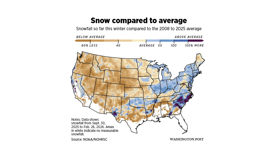
The East’s snow bonanza was driven, in part, by the dearth of it here.
“When we get these ridges of high pressure in the West, we have this bubble over us,” said National Weather Service meteorologist Steve Bodnar. “The cooler Canadian arctic air is driven sometimes over the Northern Plains and into the Northeast.”
In February, that pattern, along with a jet stream bringing lots of moisture from the southwest, brought big snow in the East.
In December, Spokane received a lot of precipitation, but it was rain, brought in with storms also from the southwest.
Snow is possible multiple days this week in Spokane, but it’s unlikely to be around for long, if it even sticks at all, said National Weather Service Meteorologist Daniel Butler. Highs are expected in the 40s on Monday and Tuesday and approaching or in the 50s the rest of the week.
It’ll be different in the mountains, however.
The Cascades are expected to receive an onslaught of snow. Stevens Pass could get 1 to 2 feet of snow through Monday evening and 4 to 7 feet Tuesday through Friday. Snoqualmie Pass could get 2 to 5 feet Tuesday through Friday.
Butler warned drivers, particularly those headed into the mountains, to carry emergency supplies, including extra sets of warm clothes, a first-aid kit, extra food and cellphone chargers.
Storms in the Inland Northwest are predicted to bring smaller, though sizable amounts, too, Tuesday through Friday, with Lookout Pass and Schweitzer Mountain getting 12 to 18 inches and Mount Spokane getting 4 to 8 inches.
It’s welcome news for winter recreationists and hydroelectric operators who have been dealing with snowfall significantly below average throughout the Northwest.
But Butler said avalanche concerns likely will grow, particularly in the Cascades next weekend as temperatures rise soon after the big snowfall.