Meet the medicane, a hurricane’s Mediterranean cousin
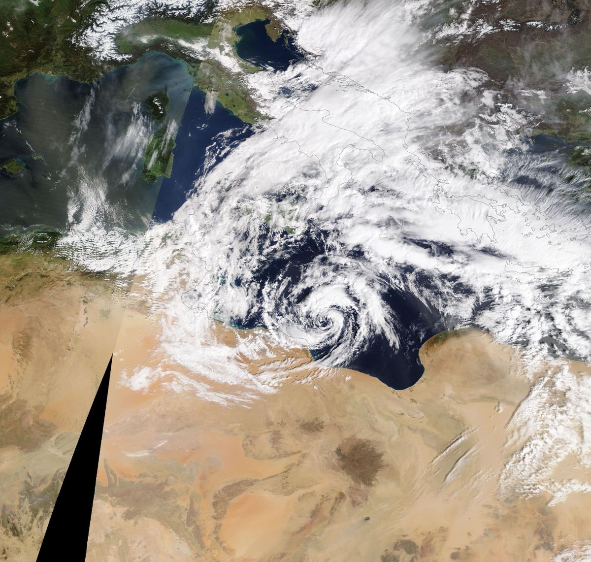
A cyclone made landfall this week in Libya, likely packing tropical storm-force winds, a few heavy rain squalls and perhaps a minor storm surge. It even had an eye-like feature on satellite.
But it wasn’t a hurricane – at least, not exactly. It was a medicane – a hurricane’s Mediterranean cousin.
Medicanes are fairly infrequent, with only a dozen forming between 1982 and 2003. Because the Mediterranean is a small basin bounded by landmasses, medicanes have a limited amount of time and energy they can feed. These systems also deal with cooler water temperatures. Conventional hurricanes usually require water temperatures above 79 degrees; medicanes have been observed with water temperatures as cool as 57 degrees.
Wednesday’s system made landfall south of Benghazi within the desert country in northern Africa, where water temperatures are around 63 degrees.
A scatterometer, or satellite-mounted instrument that estimates wind speeds based on ocean waves, suggested sustained winds of 40 to 45 mph; that is above the 39 mph threshold that would get a name (if it was a tropical cyclone).
Medicanes are not technically hurricanes, despite the similar nomenclature; after all, “medicane” is a portmanteau of “Mediterranean” and “hurricane.” Despite this, they can deliver hurricane-strength impacts and harbor some tropical characteristics.
The key differentiator is that hurricanes and tropical cyclones are warm-core systems and derive their energy exclusively from warm waters. They feed off vertical instability, or the tendency for near-surface air, heated by warm seas below, to rise into colder air aloft.
Medicanes more typically start as cold-core systems. Like other mid-latitude storms, they develop in zones of baroclinicity – or strips where air masses of different temperatures and densities clash. That causes the jet stream, or a river of winds in the upper atmosphere, to dip, occasionally pinching off eddies of vorticity, or spin. Cool, dense air spirals inward, settling to the ground and drawing more air in to fill the void. Nor’easters, snowstorms and most other continental disturbances are other examples of cold-core systems.
The key to a medicane is the gradual transition toward a warm-core system. Under the right circumstances, a cold-core pocket of vorticity (spin) can encounter warmer waters over the Mediterranean. In the absence of harsh winds tearing the fledgling area of rotation apart, it can be invigorated from the bottom up.
Most medicanes result when cold air at the upper levels fuels thunderstorm activity over the Mediterranean Sea, which then organizes around a common center.
Like a hurricane, the stronger medicanes are typically symmetrical. That’s something you don’t tend to see with a cold-core system. And likewise, they can have calm and clear eyes. That’s rare in anything but a hurricane.
Medicanes tend to be small systems – at most 200 miles across – and have much shorter life spans than their big-ocean cousins. While some medicanes have been able to stick around for a few days, like a 90-hour beast in September 1983, they tend to show tropical characteristics for only hours rather than days. Most of the time, these hybrid storms are more akin to a nor’easter that we see in winter along the East Coast.
The strongest on record was Medicane Ianos, which impacted Greece from Sept. 17-18, 2020. It briefly became the equivalent of a tiny Category 2 hurricane with winds of 95 mph.
Interestingly, Libya has seen medicanes before. In September 2023, Cyclone Daniel became the deadliest medicane on record. Despite having maximum winds of only 55 mph, it killed nearly 6,000 people by moving into Libya and causing the collapse of the Derna and Mansour dams. That brought catastrophic flooding along the Wadi Derna river, inundating large sections of the city of Derna.