Blazing new vistas

‘You get a chance to see how it all begins,” muses Mike Block, one of my hiking companions. At our feet, in a burn-ravaged forest, green fiddlehead ferns unfurl their fronds. Tiny mountain maple leaves cluster around blackened stumps. In spite of last summer’s fires scarring 160,000 acres of Glacier National Park, we gaze at the birth of a new forest.
Trails closed during 2003’s fires hold surprises for hikers exploring the park this season. Between charred logs and tall coal-colored toothpick trees, emerald shoots emerge. Splendid scenery — obscured for decades behind huge larch, hemlock, birch and cedar trees — has been revealed.
Peaks and glacier-gouged cirques that are eons older than sub-alpine firs add to the trail experience once again, now that they can be seen.
Frankly, fire improved some of the hikes in Glacier Park, as impossible as that might seem in one of the nation’s most scenic parks. Following are three notable examples.
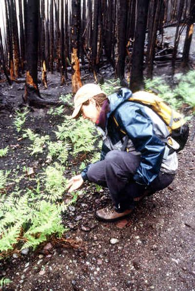
Apgar Lookout
Length: 5.6 miles round trip
Elevation gain: 1,835 feet
Note: Trail will be closed until early July for reinstallation of lookout power line.
Long relegated to the don’t-bother-unless-you’ve-hiked- everything-else list, Apgar Lookout Trail now ranks in the fistful of top park hikes. Under a thick fir canopy growing since the 1929 fire, the trail was a three-switchback uphill grunt to a dilapidated lookout where a tree-blocked view left us staring at our boots.
Most of the lookout trail was smack in the path of last summer’s 58,000-acre Robert Fire, although a mile past Quarter Circle Bridge near Glacier Park’s west entrance it slips through the fire’s fringes. Copper needles grip blackened tree limbs. Untouched rusty-leaf menziesia shrubs prove that flames leaped between tree tops here rather than smoldering across the ground.
As the trail climbs, we pass into another world, a scorched science-fiction landscape. With no underbrush, sooty soils divulge every nook and cranny, every dimple across the raven hillside. Large holes gape where roots had burned completely.
“Hikers definitely need to pay attention to footing,” said Steve Willis, National Park Service backcountry coordinator for Glacier’s west side. “Root systems can burn leaving large cavities under trails.”
Weather conditions also can pose trail hazards, he said. Trees and snags can be toppled by high winds as well as heavy rains that erode barren soils on steep slopes.
Since forest fires rarely incinerate all life to the ground, seared trees stand — some simply stripped of needles, others roasted until their limbs curl. Bark peels away in sheets, leaving unburned flaxen trunks to bleach in the sun. In the air, a faint smoky smell lingers.
Despite of the habitat trauma, this is not a dead zone. Glacier lilies nod their yellow heads as they do each spring. Bear tracks cross the trail, and mule deer pause to look at us. Small blond dots pepper black bark, signs of birds returning to the woods.
Following a fire, beetle larvae bore under the bark and become a feast for woodpeckers. We hear the faint tap-tapping of a black-backed woodpecker hunting for its dinner.
In the absence of dense foliage, we peer at views I’d never seen on this trail. Rubideau Creek drainage below is a mosaic of black, rust and green patterns. Across the valley, a train worms alongside the Middle Fork of the Flathead River, while Columbia Mountain and the Swan Range stretch southward.
“It’s a fabulous view,” a surprised Mary Witbrod gushes as we reach the lookout. Atop Apgar, we utter thanks to the fire crews who saved the lookout, which had recently been renovated in a project to restore Glacier’s historic structures. Its solid decks are a perfect place to enjoy lunch and a view that’s been restored, too.
Although low in comparison to other peaks, Apgar’s 5,236-foot summit is situated at the base of 10-mile-long Lake McDonald. The view is a tableau of unbelievable proportions as the million-acre park sprawls from Mount St. Nicholas to Kintla Peak. All six of the park’s 10,000-foot peaks dominate the skyline.
For those who struggle up the trail’s three switchbacks, the reward now far exceeds the hike. Witbrod croons repeatedly, “I gotta bring the family here.”
The Loop
Length: 8 miles round trip
Elevation gain: 2,400 feet
Note: The Loop can be a continuation of the one-way hike from Logan Pass, for a total of 11.6 miles. The Loop section is the only portion of the Highline Trail that burned.
Five of us — mostly park guides — concur: the burned southwest slope of The Loop will bake us on hot August afternoons! But as we re-explore the familiar trail, “wows” punctuate every turn.
At The Loop on Going-to-the-Sun Road, we leave singed cottonwoods and climb toward Granite Park Chalet, a popular dayhike and overnight destination. This trail took the brunt of the lightning-caused Trapper Creek Fire, which devoured 19,000 acres of forest last summer as winds shoved flames up toward the Continental Divide.
The creek rages from high above, a scene we can appreciate now that fire has cleared the alder thickets, at least for a few years. Branchless charred spires replace 70-year-old sub-alpine fir and birch. Lichens are gone.
“You can see the story of the forest,” said Carrie Simpson, a Forest Service fire interpreter. In fact, two stories are told here—one of fire and one of growth. In a spot of high severity burn, Cheri LeBleu observes, “Flames ran across the ground here and ate up all the trees.” Both the canopy and understory vanished.
But beneath blackened trunks, stark lime flora breeds. While flames raged overhead, soils protected seeds and bulbs. Cow parsnip and death camas, bronze bells and elderberry — we count more than 30 species of emerging sprigs.
Woodland stars greet us with white blooms, and the saprophyte broomrape pokes its purple tubular flower through neighboring geraniums. Looking like shrunken extraterrestrials, morel mushrooms sprout along the trail.
Between switchbacks, we meet Rick Yates, a Glacier Park wolverine researcher. He assures us his carnivores will love the burns as ground squirrel populations burgeon in the fire’s aftermath. Fires put nitrogen and carbon into the soil and nutrients are concentrated in new buds.
Energy-packed grasses and forbs attract herbivores, especially deer and elk. In turn, predators follow the prey.
For three miles, the path climbs through new sights. Water spills everywhere. Instead of streams visible only when they trickle over the path, we glimpse falls spewing from rocks high uphill and cascading far below. Across the valley, Flattop Falls drops toward the confluence of McDonald and Mineral creeks. Above all, snow-covered Heaven’s Peak is never out of sight.
We leave the burn’s fingertips and reach the upper basin’s lush meadowlands where sub-alpine thickets hide all traces of recent fire. Our favorite huckleberry bushes still line the trail. We’ll be able to sit at the chalet this summer and continue our tradition of watching grizzlies forage in Bear Valley.
Speaking for all of us, LeBleu confesses, “I’m glad the eyeball-high brush is gone.” In grizzly country, visibility is comforting.
North Shore Lake McDonald
Length: 6.6 miles one-way
Elevation gain: none
Note: Visitors can get good views of the Robert Fire by hiking two or three miles on this trail starting from either the west or east end.
Previously an unremarkable hike with peek-a-boo views of Lake McDonald, the gentle North Shore Trail now tells the saga of an August afternoon when the Robert Fire raced over 12,000 acres.
We start near Fish Creek Campground and hike where embers struck the forest floor, igniting trunk bases but barely touching fir tops overhead. Red-gold needles cling stubbornly to limbs or carpet the ground. Down the trail, fully blackened trees are a clue for hiker-detectives that they are moving into an area where the flames had grown bigger.
Even though needles, limbs, and brush burned here, green bog orchids swell from the ash.
After two miles, the trail pierces a severe hot burn where huge old conifers once reigned. Little new growth dots this pitch-black landscape. Limbless trunks perch precariously on nearly gutted bases. In our lifetime, woodpecker holes will house birds and squirrels in these dead trees as they become surrounded by new woodlands.