In waiting

Wilderness is argued to be either the ultimate protection for America’s choice wild lands or a drastic lock-up that excludes the use of motorized equipment, not just for recreation but also for management.
The gridlock of debate has left millions of acres of federal land in limbo since the Wilderness Act was approved in 1964.
The sentiments of Vicki Gish of Deer Park fall in the middle somewhere, as she appraises wilderness from the perspective of an equestrian and tireless volunteer who has cleared miles of neglected forest trails with the Backcountry Horsemen of America.
“I love wilderness,” she said last week at a Colville National Forest meeting to address recreational travel on the forest. “But roadless (designation) is the way to go because, honestly, a cross-cut saw is slow, hard work.”
Tim Coleman, a resident of Republic and one of the region’s lead conservation organizers, contends the U.S. Forest Service can’t be trusted to count the acres of roadless areas much less protect them with ill-defined “roadless” designation.
“The Wilderness Act is our only hope for many of these areas because the Forest Service and Congress are very creative about inventing emergency reasons to circumvent environmental laws and build another road.”
Coleman is the former executive director of the Kettle Range Conservation Group, which merged this month with the larger Northwest Ecosystem Alliance based in Bellingham. In 1999, the KRCG joined 28 conservation groups to launch a “Wild Washington” campaign to designate more official wilderness in the state.
“Washington has done a good job of protecting the high elevation rock and ice,” Coleman said at the time, pointing to classic wilderness areas such as the North Cascades, Mount Rainier and Glacier Peak. “But the most critical areas for wildlife are still open to development.”
Such grassroots wilderness advocacy sprouted in about 20 other states in 1999. Around the same time, President Bill Clinton was preparing a bold executive order to protect about 58 million undeveloped acres of national forests as “roadless,” a designation that’s less restrictive than wilderness, but also less secure.
Within weeks of taking office in 2001, President George W. Bush began taking steps to overturn the Clinton roadless rule. Public comment currently is being accepted on a Bush administration alternative.
Meanwhile, the Wild Washington campaign continues to seek wilderness protection for prime cuts of the remaining federal forest roadless areas, said Chase Davis, Sierra Club regional representative.
Notable among these areas are additions to the Wenaha-Tucannon Wilderness in the Umatilla National Forest as well as Colville National Forest areas in the Kettle River Range near Republic, the Abercrombie Mountain area west of Metaline and additions to the Salmo-Priest Wilderness.
The 1984 Washington Wilderness Act, ushered through Congress by Rep. Tom Foley, added 24 national wilderness areas totaling nearly 2.6 million acres. That brought the state to 30 wilderness areas totaling 4.3 million acres of national forests, parks and desert areas, or 10 percent of the state’s area.
Conservationists estimate that national forests alone have another 3.7 million acres in Washington that remain unroaded and pristine, but unprotected from logging and other development.
These are the lower elevation areas coveted by a wide range of interests because of their accessibility and value for wildlife, motorized recreation and timber production.
The only Washington wilderness proposal to get anywhere since the 1984 is the Wild Sky Wilderness bill, which would protect about 103,000 acres in the North Cascades and headwaters for the Skykomish River. The proposal has had bipartisan Congressional support and has twice passed the Senate only to be thwarted in the House.
Idaho efforts stall
While seeking approval for additional wilderness since 1964 has been arduous in Washington, it’s been all but impossible in Idaho.
No wilderness areas have been designated in Idaho since 1980, even though the state had the most national forest roadless acreage in the lower 48 states — 9.3 million acres — identified in the Clinton roadless rule.
Currently, Idaho has six wilderness areas totaling about 4 million acres, or 7.6 percent of the state’s area.
The timber industry generally agrees that some remaining Idaho roadless areas lend themselves to formal wilderness designation, said Jim Riley, president of the Intermountain Forest Association based in Coeur d’Alene
The industry’s hang-up isn’t necessarily over the specific areas proposed for wilderness, he said.”There are other lands we believe should be available for multiple use purposes including forest management,” he said. “Wilderness advocates just want to legislate the wilderness and then come back and fight over everything else. Because of that they have been unable to accomplish wilderness legislation.”
Idaho and Montana share one of the classic examples of clashes over proposed wilderness areas.
Since the 1970s, conservation groups and even the Forest Service have recommended that between 225,000 and 275,000 acres along the Montana-Idaho border between Superior and Lolo Pass be designated as the Great Burn Wilderness.
This wild landscape transformed by glaciers and fire has everything a wilderness needs except consensus.
Great Burn defined
The name Great Burn stems from the epic 1910 forest fire. Hundreds, perhaps thousands of lightning- and human-caused blazes were burning with relatively modest impacts in a tinder-dry year before a number of them converged on Aug. 20 and exploded into an inferno whipped by hurricane-force winds.
When it was over two days later, 78 firefighters and seven civilians were dead.
The Idaho towns of Wallace, Kellogg, Osborne, Burke and Murray were ravaged.
The Montana towns of Taft, DeBorgia, Saltese, Haugan and Tuscor were consumed.
Much of a 3-million-acre path 260 miles long and 200 miles wide from the Salmon River north to Canada was charred.
Most of the destruction occurred in just six hours.
The roadless remains of the Great Burn make an extraordinarily diverse and captivating wilderness candidate.
The 1910 fires essentially transformed a subalpine area into an alpine environment that is in a subalpine setting, said Kevin Foss, a former Lolo National Forest trails coordinator who recently transferred to Oregon.
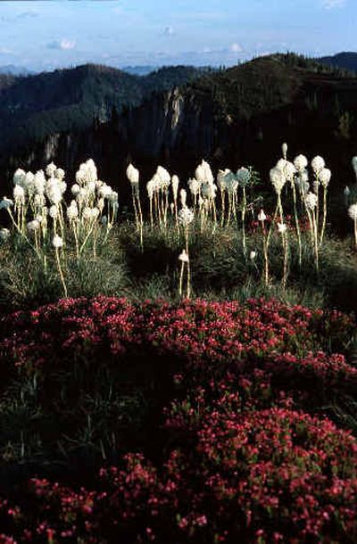
“In other words, two environments exist in one area,” he said, noting that beargrass grows at lower than normal elevations and cedar trees grow at elevations to 6,000 feet, which is higher than normal for the Bitterroots.
The 600 inches of snowpack that irrigates portions of this area produce particularly robust Indian paintbrush. Fireweed grows at almost all elevations in the Great Burn, sometimes in colorful contrast to silvery snags. Insects are exceptionally diverse, especially butterflies.
Mountains in the Great Burn are not as high and craggy as in the Bitterroot Range farther south. But Rhodes Peak, the burn’s highest at elev. 7,930 feet, is a lofty goal for the hiker seeking a view. The nearby crags require climbing skill to scale in order to reach the haunts of the area’s mountain goats.
Odd formations in the Williams Peak- Shale Mountain area resemble the sawtooth backs of prehistoric dinosaurs.
Dave Cook of Spokane Valley hiked the open ridges into Rhodes Peak last September and saw no one in three days. “I’m amazed there can be an area this beautiful and untouched and just a day in from Interstate 90,” he said.
The Great Burn encompasses the headwaters for Fish, Kelly and Cayuse creeks and a portion of the Lochsa River, all nationally know for their native cutthroat trout fisheries.
The cirque basins along the Stateline National Recreation Trail, many of them still studded with decaying snags from the 1910 fire, are settings for jewel-like lakes.
Pockets of forest that survived the Great Burn hold 500-year-old Western red cedars, such as those below Siamese Lakes, and are flanked by vast meadows that have evolved from the burn itself.
Subalpine tundra covers much of the high country with gnarled whitebark pine on the ridges. Only about 5,400 acres within the wilderness proposal have been identified as timber suitable for logging.
“The proposed wilderness ranges in elevation from 3,200 feet to 7,900 feet,” Foss said. “That means the Great Burn includes not only summer range for elk, but also winter range, which would be an unusual but welcomed combination for official wilderness.”
The area is one of four the Sierra Club is promoting for wilderness along the Lewis and Clark Trail.
“We feel it’s a fitting tribute to the expedition and the bicentennial to assure that future generations can see the area in same way we see it today and the way Lewis and Clark saw it 200 years ago,” said Bob Clark, who’s been tracking the Great Burn wilderness proposal for two decades from the Sierra Club’s Missoula office.
But the proposal hasn’t gone anywhere except perhaps downhill since it was recommended for wilderness in Forest Service management plans in the 1980s.
The Clearwater National Forest management plan authorized in 1987 included a wilderness recommendation the timber industry considered a balanced approach, Riley said.
“We helped put that plan together along with the Fish and Game Department and others,” he said, “but while a forest plan can recommend areas for wilderness, only Congress has the authority to designate wilderness.
“As various wilderness proposals have surfaced, we’ve said we’d be prepared to support legislation providing it accomplishes the balance of releasing lands outside the wilderness for multiple use.
“Where legislation has been hung up for better part of two decades, there was widespread agreement on writing law for wilderness lands but disagreement for laws on active management of lands that are not wilderness.
“Once the attitudes about that change, additional legislation can be forthcoming.”
Tale of two forests
The two national forests that manage the proposed Great Burn Wilderness have fueled controversy over the proposals with their divergent management policies.
The Lolo National Forest has managed 98,000 acres proposed for wilderness on the Montana side of the stateline as a primitive area with roads and only minimal trail development to keep the wilderness qualities intact. In winter, snowmobiling is prohibited, much as it would be in an official wilderness.
The Clearwater National Forest, which manages 150,000 acres proposed for wilderness on the Idaho side, has been much more lenient, allowing snowmobiling and other motorized traffic into the proposed wilderness zone.
Both forests, incidentally, are revising forest management plans originally authorized in the 1980s. In the next week or so, the Clearwater plans to release a draft plan that includes wilderness recommendations. Other wilderness proposals the plan will revisit include the 66,700 acres originally recommended for the Mallard-Larkins primitive area.
The current plan has been disputed since its inception.
“The Clearwater has opened 55 percent of the trails in the recommended wilderness to motorized use, and I’m talking about inside the area the Forest Service recommended,” Clark said.
“To make things worse, motorcyclists are constantly pushing the envelope into the proposed wilderness on trails that are not open to motorized use. The cumulative effect is galling.”
To fight a forest fires in 1964, Clearwater officials authorized a bulldozer to gouge a road up a former stock trail to Fish Lake, the largest backcountry lake in the upper North Fork of the Clearwater region. The vegetation was allowed to grow back to create a single track trail once again.
The forest’s 1987 management plan included Fish Lake in its wilderness recommendation.
But by the early 1990s, as ATV sales were skyrocketing, the Fish Lake trail once again looked like a road.
Doug Gober, former North Fork District Ranger in Orofino, lamented the management dilemma. “Six out of 10 rigs that pass by my office have a motorbike or an ATV in the back,” he said.
The forest management plan didn’t address the issue of motorized access because no one anticipated the capability and popularity of modern off-road vehicles, Gober said.
“On a summer weekend, it’s not unusual to see 30 or more ATVs up there at a time,” Clark said. “The noise and dust are nauseating, to say the least, to people who value a wilderness experience.
“The mistake the Clearwater officials are making is assuming the Great Burn’s local constituency is in Orofino,” Clark said. “In fact, the Great Burn is much closer to Missoula than to Orofino. The real locals are the Western Montanans who come with backpacks, huckleberry buckets and fishing rods, not ATVs.”
Last winter, however, a judge turned down an appeal by conservationists to stop motorized travel into Fish Lake.
Clark said the Great Burn Wilderness has solid support in Missoula among hunters, anglers and hikers but concedes that consensus is harder to reach in Idaho, where off-road vehicle enthusiasts and timber groups are more entrenched.
“The forest planning process is different from forest to forest,” Foss said. “Most people don’t realize that. They think the ‘national’ in National Forest System means that all the forests are on the same page. Not so.
“When adjoining forests have different management outlooks, it causes problems and creates hurdles. It’s not so much a local problem as it is a national problem. It would help if everybody was on the same page.”
Gary McFarland of the Moscow-based Friends of the Clearwater, said he’s been working on the Great Burn Wilderness proposal, in his words, “basically forever.”
“It’s one of the special areas that’s eluded wilderness designation up to this point even though it’s a place the majority of Idahoans would recommend for protection,” he said.