Worth the effort

Canyon Fork Trail No. 78 is a great hike to be enjoyed before winter arrives – both to enjoy the fall foliage colors and to avoid snow-covered trails in the hills above 5,000 feet.
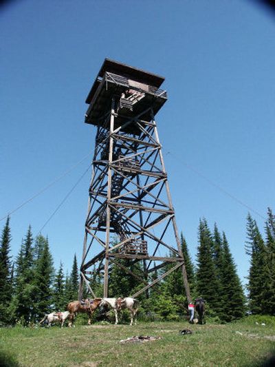
The hardest part of this hike is getting there. With missing, and or bullet-riddled, unreadable signs and plenty of side roads, finding the trailhead can be a challenge. The good news is the view from the top and the historic lookout tower are worth the effort.
Leaving the summit of Spades Mountain at the trailhead sign near the lookout tower service road, the trail descends slightly until crossing Forest Road 1511. Steeply dropping with two switchbacks, the trail crosses a logging road then descends through heavy timber to a ridge between Canyon Fork and Nicholas Creeks. Next, it drops with four switchbacks in less than a mile to the end at Canyon Fork Creek.
Access: from U.S. Highway 95, and Interstate 90, go north on U.S. 95 for approximately 7 miles. Turn right on Lancaster Road and go about 6.9 miles. Turn left on Hayden Creek Road and go 2.2 miles to a right turn on Forest Road 206 (the sign was almost unreadable during my last trip). After 9.9 miles on the windy and narrow dirt road, you arrive at Burnt Cabin Saddle, where the road branches to four roads and one trail). Go left on the road, which is lowest on the hill (Forest Road 1511). Continue to bear right on this road for approximately 2.2 miles, then go left, then another almost immediate left for 1.3 miles to the top of Spades Mountain and the trailhead. The tower cannot be seen from the road. For those with a GPS, the coordinates are N 47.47.737, W 116.34.156.
Length: approximately 2.7 miles one-way.
Elevation: trail begins at 5,038 feet above sea level, making several steep descents.
Use: light.
Trail condition: Mostly well-packed trails with narrow and steep portions.
Difficulty: moderate to difficult.
Restrictions: no motorized vehicles; please pack out your trash.
What to see: great views of Hayden Lake and the Kootenai County valley, along with deer, turkey and other wildlife.
Special features: The fire watchtower is impressive in height above the timber. This tower is up for consideration for inclusion in the U.S. Forest Service Lookout Tower program, allowing rental by the public. There is a Geocache (the treasure hunt game, using clues from the Web site, www.geocaching.com) near the (not on it) tower.
Preparation: if you take these directions with you, your chances of getting there will be greatly increased. A free trail guide available at the Coeur d’Alene River Ranger District, Fernan Office, 2502 East Sherman Ave., in Coeur d’Alene (208) 664-2318, www.fs.fed.us/outernet/ipnf) or from the U.S. Forest Service, 3815 Schreiber Way in Coeur d’Alene. The ranger office suggests leaving your trip schedule with a responsible person. Detailed topographical maps are available for purchase from the following vendors in Coeur d’Alene: Black Sheep Sporting Goods, The Yacht Club Sales and Service and North Idaho Blueprint.
Gear: Good hiking boots are essential and hikers should dress for changing conditions and carry drinking water (no water is available along the trail), insect repellent and a first-aid kit. Hunter orange outerwear is recommended during hunting season to avoid being mistaken for wild game (or a road sign).
Note: Spades Mountain Lookout Tower was built in 1923 as a camp lookout, with a 50-foot pole tower and a small cabin. A 54-foot tower with living quarters was built in 1941, and then moved to Long Mountain in 1963. The current 67-foot lookout tower was built in the ‘60s and last staffed in the ‘70s.