Deep in the forest
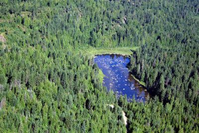

There is a reason this lake was lost. Sunk deep in the trees and overshadowed by the magnificent Lake Pend Oreille, this little body of water can be tough to find. Offering the peace and quiet the name implies, hikers can relax on benches overlooking the lake. The gentle trail loop is a perfect jaunt for a hot summer day and the nearby beaches of Green Bay provide for a refreshing swim.
The road trip to Lost Lake passes through the scenic town of Garfield Bay, home of the Harbor Marina, two convenience stores and a Forest Service campground with a boat launch and swimming area. Garfield was originally known as Midas and was settled by Jim McNicholas, who lured investors and prospectors to the area to search for gold. Unlike Lost Lake, the investors’ money was lost forever. McNicholas went to jail and Midas became Garfield Bay.
Access: From the intersection of I-90 and U.S. Highway 95, go north on U.S. 95 for 39 miles to Sagle. Turn right on Sagle Road and go 7 miles to Garfield Bay Road, taking the fork to the right. Go 1.5 miles to a left on Garfield Bay Cut-Off Road, then .4 miles to a right on Mineral Point Road 532 and go 4.5 miles to the end of the road.
Length: 2.3-mile loop.
Elevation: 2,200 feet with an elevation gain of 200 feet.
Use: Light.
Trail condition: Well-packed trail.
Difficulty: Easy.
Restrictions: No motorized vehicles.
What to see: White-tailed deer, squirrels, black bears, coyotes. Bobcats are known to reside in these forests of ponderosa pine, Douglas fir, poplar and western larch.
Special features: Take road 532A for the Mineral Point Picnic Area, which has toilets, picnic tables and the trailhead for Trail 82. Take road 2672 for Green Bay Campground (beach campsites, tables, grills and toilets; Lake Pend Oreille is home to a variety of fish, including rainbow trout, lake trout, perch, crappie, bass, whitefish and Kamloops. Along with fishing boats trolling for the big ones, bald eagles and osprey are often seen diving for the catch of the day. There is a Geocache near Lost Lake – see the Web site www.geocaching.com).
Preparation: Free trail maps are available from the Sandpoint Ranger District Office, at 1500 Highway 2, Suite 110, Sandpoint, ID 83864 ); (208) 263-5111. Information is available on the Ranger District’s Web site, www.fs.fed.us/ipnf/sandpoint/. Topographical maps are available for purchase from the following vendors in Coeur d’Alene: Black Sheep Sporting Goods, The Yacht Club Sales and Service and North Idaho Blueprint.
Gear: Good hiking boots are essential and hikers should dress for changing conditions and carry drinking water and a first aid kit.