Northwest girds for next earthquake

SEATTLE – Five years after a 6.8-magnitude earthquake rocked the Pacific Northwest, officials say the region could be in for an even stronger shaking – and they say they’re trying to learn from the disastrous response to Hurricane Katrina.
Representatives of more than 150 government agencies, hospitals, utilities and other organizations planned to meet today and Thursday in suburban Bellevue to conduct the third in a series of emergency response drills – this one dealing with earthquake response.
“Hurricane Katrina illustrated for us again that providing essential services will be a challenge in any major disaster,” said Steve Hickok, deputy administrator of the Bonneville Power Administration, the federal power marketing agency for the region. “This exercise will help us improve the region’s strategies and preparations for restoring vital services.”
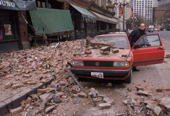
The Nisqually earthquake just outside Olympia on Feb. 28, 2001, caused $2 billion to $4 billion in damage, collapsed some buildings and roads, and cracked the Capitol Dome, but it caused no fatalities or major injuries. It would have been a lot worse but for the depth of the epicenter, 35 miles beneath the surface.
Recent seismic research indicates a bigger earthquake – one that shakes five to 10 times more violently – could be coming. The Nisqually earthquake wasn’t on the Seattle Fault; one there could cause the ground to drop 6 feet, state Emergency Management spokesman Rob Harper said.
Bill Steele of the University of Washington’s seismology lab said that thanks to a pilot project called the Advanced National Seismic System, 40 seismic monitors had been placed around the region by the time of the Nisqually quake, making it the best-documented major earthquake in the nation’s history. There are now 100 such monitors in place.
Geologists discovered, for example, that the ground shook a lot more in Seattle than it did in Tacoma, even though Tacoma was closer to the epicenter. That information helps scientists understand the distribution of earthquake energy.
In addition, new laser-aided topographical imaging has helped scientists discover at least 10 new faults in the region, including some on the Olympic Peninsula, under south Whidbey Island and near Bellingham. Each is capable of producing magnitude-7 earthquakes, Steele said.
“We’re just learning so much, and that’s thrown our whole tectonic model for the region into doubt,” Steele said. “There are so many of these faults, and they all have earthquakes.”
Today’s emergency exercise in Bellevue follows two other disaster preparedness exercises involving a wide range of officials and critical service workers. One exercise in June 2002 focused on a terrorist attack, and one in September 2004 focused on a cybersecurity attack.
This one will simulate what might happen if a 9.0 quake hit the Northwest, shattering highways and buildings, overwhelming hospitals, breaking pipelines and knocking out power. More than 300 people planned to take part. Seeing the government’s failed response to Katrina has helped local officials realize that they need to expand their focus beyond the immediate effects of a disaster.
“You’ve got to look at very long-term impacts, with people out of their homes for months or years. The magnitude of the population displaced is very troubling,” Harper said.
“You look at ‘OK, how many of our hospitals might be functioning?’ There are pockets of New Orleans that still don’t have power. Where do you move these people if you have to move them? We don’t have answers right now.”