Senior moment

The trek was brutal. Both men pushed themselves to the edge of their mental and physical limits as they gained and lost about 60,000 feet in elevation over the 11 days.
“This is no walk in the park,” Shepherd said. “There were several places where we came out of the woods and were above sheer cliff faces. We got lucky. Most of the time, we came out perfect when it came to route finding.”
Asked if either would attempt the feat again, both replied with an emphatic “No.”
“It was unbelievably tough,” Hess said. “Neither of us are quitters. Once we start something, we are going to finish it. But sitting here thinking about doing it again, no way. It’s just plain dangerous.
“I fell down so many times,” he added. “You’d fall and then the guy still standing would have to come help you up. Some of those falls were really bad. You take a tumble with a 40-pound pack on your back and nothing good is going to happen. My trekking poles saved me a couple of times. Now they have some real bends in them.”
It took the pair longer to make the trek than they had anticipated. On the ninth day, the weather deteriorated into a mixture of fog, sleet, rain and wind. The two were in such bad shape that they were forced to hike out with eight miles remaining, making it to the safety of Baker Lake Resort. During the two-week hiatus, both men visited doctors.
“My legs were killing me,” Hess said. “I laid in bed for three days with my feet up. My legs were so painful, I could barely move them.
On Sept. 15, they hiked to Crater Moraine and camped. The next day, they returned to where it all began — Schriebers Meadow — to finish the trek.
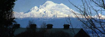
What adds to the pair’s accomplishment is their ages. Both men are retired. Hess is 65. Shepherd is 63. Both men have worked and hiked extensively upon the trail that runs 1,200 miles from Cape Alava on the Olympic Peninsula to Glacier National Park in Montana.
Max Eckenburg, an assistant Forest Service ranger in the 1930s, spent years on Mount Baker attempting to create a trail around the mountain. He was unable to find a hiking route between Camp Kiser and Rainbow Creek.
In 1970 and 1971, Forest Service ranger Baynard Tucker set his sights on creating the “Mount Baker Loop, Trail No. 615.” He envisioned a trail similar to the 93-mile Wonderland Trail that circles Mount Rainier.
Tucker detailed his efforts in a 30-page report that broke down the would-be trail into six segments. Only a small portion of a single segment was ever built. That portion is the Scott Paul Trail on the south side of the mountain.
“Actually, he did an excellent job of mapping,” Hess said of Tucker. “Of course, his route was a little different because he was looking to build bridges and needed sections where there was rock on both sides (of the water to build the bridges) and he wanted to keep it low in elevation. We needed slow, wide sections of water (to cross).”
Tucker’s plan was to blast out portions of rock for the trail. That wasn’t an option for the duo. They were forced to use rope, fingers and feet, taking the term bushwhacking to the extreme.
Sections of Tucker’s mapped area had been carried away by avalanches. Others led through such thick brush that is was easier to hike down the middle of streams.
After departing Schriebers Meadow on Aug. 22, Hess and Shepherd picked up the east end of the Scott Paul Trail before venturing into a valley and continuing cross country to Baker Pass and the Middle Fork of the Nooksack River.
The terrain was nothing like what they had seen on the flights they had taken over it.
“The problem with aerial reconnaissance is that it makes everything look flat,” Hess remarked. “This wasn’t flat.”
Once they reached the river, it was raging. The high water kept Shepherd and Hess at bay.
“We couldn’t get across,” Shepherd said. “So we waited it out. The next morning, the water level had dropped at least a foot and we were able to get across and continue.”
Toward the Black Buttes, fog engulfed the pair, making it dangerous as they trekked along a snowfield. They were forced to retrace their steps and continue below the snow line.
Reaching Thunder Glacier, the two came upon parts of a crashed Naval Air Station Whidbey PV-1 Ventura. The plane went down on Aug. 29, 1943, while practicing navigating between Everett and Bellingham, killing all six crew members. The wreck was discovered in 1994 after 51 years under the glacier.
“We found machine gun ammunition, engine parts, landing gear and small shreds of aluminum parts,” Shepherd said. “Up under the mud flow, you can see there are larger pieces still under the glacier.”
After camping below the glacier, the pair followed Heliotrope Ridge for a mile, then crossed up to Bastille Ridge. While hiking the ridge, they encountered a piece of surveyor’s tape believed to be from Tucker’s expedition.
Chowder Ridge brought about an experience Hess hadn’t had in quite a while.
“I was hanging on by my fingertips,” Hess explained. “The cliff face was nothing but loose rock. It’s the first time I’ve had sweaty hands in a long time. It was real nerve-racking.”
The men glissaded down Cougar Ridge before trekking toward Bar Creek.
The fog and rained rolled in. Trying to get up cliff faces in the rain was difficult. The rock was very slick. Hess described having to climb the remnants of a once thundering waterfall now streaming with rainwater.
Then came the portion of the trek that both described as the most trying. Devil’s Club Camp lived up to its name.
From Park Creek to Devil’s Club Camp was a mere 2.3 miles. That distance took a hellish 11 hours due to the thick brush and the weather.
“That was a forced march,” Hess said.
“In a single day, the weather turned from summer to fall,” Shepherd added. “It was awful. The brush was so thick, I just remember looking for swaying plant tops (as Hess made his way through) and I knew that was where I needed to go.”
Devil’s club is a bush that can grow to about 10 feet and can be as much as 14 feet wide. But what makes this plant particularly nasty is its yellow spines. Shepherd and Hess had no option but to trek right through a forest worth of it.
“The stuff was head-high and higher and all over,” Hess said of the devil’s club. “I had to use my trekking poles to push through, push out and then I stepped through. I picked about 200 spines out of my hands. My legs were all swollen up. It was miserable.”
In the end, howeer, it was Shepherd and Hess who came out on top.
“This was one of the top-10ers in my life,” Hess admitted. “I’ve done a lot of things, but this is one I will never forget.”