Rough things afoot

Glacier National Park’s mountains have stood for over 60 million years, so it’s hard to imagine change. But that’s exactly what hikers should expect this summer. When last November’s Pineapple Express rumbled through the Northwest, floods pummeled park roads and trails. To compound the damage, record-breaking December winds toppled many more trees than normal.
For hikers headed to the park famed for its 700 miles of backcountry trails, rough routes are afoot this summer. On some trails, mounds of rubble obliterated walkways, bridges washed downstream, water ruts swelled into deep trenches, and trees blew down across paths. “The flood damage has not been predictable,” says Cory Shea, foreman of Glacier’s west side trail crews. “We’re finding blown out trails where streams usually trickle dry by July.”
Reports from the trail
Trails throughout the park suffered various degrees of destruction. While trail crews await higher elevation snow melt to assess total damage, reports from lower elevation trails trickled in. Bridges could not be found. Streams leapt their banks. Rocks buried paths. In one stretch along the Lincoln Creek Trail, 200 trees fell; along Park Creek on Glacier’s south end, 400 trees obscured the path.
Glacier’s central swath bore the brunt of the flood’s worst. Many Glacier, the Upper McDonald Creek drainage, and parts of the St. Mary River drainage lost multiple bridges and small trail segments to washouts. On the Highline Trail between Logan Pass and Granite Park Chalet, debris piled across the route. Gravel buried 100 yards of trail in the Big Bend bowl before the Haystack switchback and a large hole washed out north of Haystack Butte. Other areas such as Two Medicine, the Belly River, and Goat Haunt survived less scathed.
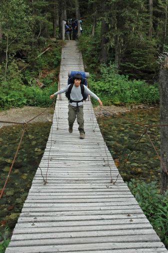
On the North Fork backpacking trail looping from Bowman Lake to Kintla Lake, Shea reports that flooding ripped out five bridges along the Bowman Lake Trail to Brown’s Pass and re-routed Bowman Creek by one-fourth mile. It also swept away the head of Upper Kintla Lake suspension bridge and careened the creek down the trail. Between both Kintla Lakes, an avalanche chute buried a quarter-mile long section of trail in rock rubble.
While crews labor to make trails passable for hikers and horses – sawing logs, clearing rocks, rebuilding blown out segments, and installing bridges – the repair work will extend beyond one season. Where streams are easily forded, the park service may hold off on building new bridges to avoid further loss – especially in big alluvial fans where streams braid through gravel bars. “We’re replacing bridges where we can,” notes Shea. “But in many cases, we may wait a year for stream beds to stabilize. It’ll be a while before we get a finished product.”
While crews saw downed trees quickly from trails, a project lengthened only by the sheer volume of blowdown, trail tread repairs take longer. Shea notes that a deep washed out stream can take three to four weeks to fix just enough for safe stock passage.
Despite flood damage, Glacier’s trails are open for hiking, and locals are out marveling at nature’s new handiwork. Given conditions, smart hikers will check with the park for special hazards and be extremely cautious around water – the park’s leading cause of death. Shea adds, “Hikers should be prepared to ford more streams than usual and be ready for rough stretches of trail.”
Heading for the heart
Compounding trail damage, Going-to-the-Sun Road – the main artery to Glacier’s central trailheads – lost 102 feet of two-lanes east of Logan Pass. Since the National Park Service had scheduled nearly a decade of intensive Sun Road improvements to begin this summer, flood repairs folded into previously engineered construction. Despite construction, the National Park Service plans for two-way traffic over the entire 52-mile stretch this summer.
For drivers, July and August daytime delays should tack on only an additional 30 minutes between West Glacier and St. Mary – high in alpine sections with views of ice-gouged scenery. But for hikers, on July 1 the park inaugurates its new free shuttle system designed to reduce traffic. “It’s voluntary,” pointed out Gary Danczyk, park service project manager for Going-to-the-Sun Road mitigation. “People who like to drive will have less competition.”
For hikers, the shuttles are a windfall, simplifying point-to-point logistics on favorite one-way routes like the 11.6-mile Highline Trail or 10.3-mile Siyeh Pass. “Hikers can get off at one trailhead and take a different bus back from another,” said Danczyk. “Instead of a car left all day at The Loop for hiking the Highline Trail, the combo of hiking and shuttle should be a winner that will help with congestion.” No more mad morning rush to grab parking slots at popular trailheads.
The new biodiesel shuttles stop at 16 different spots – campgrounds, hotels, motels, visitor centers, and the new 4,200-square-foot Apgar Transit Center near West Glacier. With parking, interactive kiosks for travel information, and restrooms, the transit center serves as the west-side nucleus for the no-ticket-needed shuttles.
Beginning at 7 a.m. and departing every 15 minutes, 12-passenger Sprinters connect the west side to Logan Pass, where hikers may transfer to 23-passenger Optima buses running the east-side route every 30 minutes toward St. Mary Visitor Center. Heading both eastward and westward, the last shuttles depart Logan Pass at 9:30 p.m. Designed to lessen congestion during peak summer season, the free shuttles will operate through Labor Day weekend.
Getting off the beaten path
For those looking to escape Going-to-the-Sun Road construction, you’ll find a plethora of trails. Convenient to West Glacier, Apgar Lookout requires a half-day to reach a viewpoint to spot all six of Glacier’s rugged highest 10,000-footers. Located 1.9 miles down the Glacier Institute road just east of the west entrance station, the trailhead leaps into a 1,835-foot, three-switchbacked, 2.9-mile ascent through silvered toothpicks standing from the 2003 Robert Fire. The summit is worth the climb with Lake McDonald sprawled at its foot.
If you’re looking to avoid the mayhem of populated trails, head to remote parts of the park. With miles of potholed, dusty dirt road accesses to the North Fork, you’ll run into fewer folks on day hikes and even less backpacking. Located 32 miles north of Apgar via the North Fork Road or 35 miles by the Inside Road, Bowman Lake Campground serves as a launch pad for the 12.4-mile Quartz Lake Loop. The trail climbs over Cerulean Ridge to reach a necklace of forest-rimmed fishing lakes. Elevation gain comes in two segments – 1,470 feet en route to Upper Quartz and 1,000 feet between Lower Quartz and the Bowman Trailhead.
For backpackers, the 37-mile Bowman-Kintla Loop links forested trails over 7,478-foot Boulder Pass, one of the few places in Glacier where alpine larch flourish. While the trail meanders gently along valley floors, valley head paths sweep on steep climbs to high wildflower meadows. Hole-in-the-Wall campground sits in a large cirque that swings up past dwindling Boulder Glacier and Boulder Pass campground to nab one of the best views of remote Kintla Peak’s Agassiz Glacier.
Expect rougher things afoot on Glacier’s trails this summer. But you’ll marvel nature’s new etchings.