Mount Rainier trails magical as fall approaches
In September, something magical happens to the hiking trails on the northeast side of Mount Rainier National Park.
The crowds disappear.
As the National Park Service celebrates its centennial, there’s renewed interest in “America’s best idea.” Visitation nationwide peaked in late August when special programs celebrated the 100th birthday. At Mount Rainier, hour-long waits to get into the park were common.
While birthday parties are fun, it’s also nice when everyone goes home.
“Fall hiking is wonderful,” said Raphael Hagen, interpretation park ranger at Sunrise Visitor Center in Mount Rainier National Park. “The crowds drop off considerably.”
“You can feel the difference in crowds after Labor Day,” said Kindra Ramos of the Washington Trails Association. September hiking is great, she said, because “you have the fall color and there are no bugs.”
The clock is ticking for anyone interested in fall hiking on the high trails of Mount Rainier. Snow typically closes access to Sunrise (6,400 feet) by early October. Chinook Pass (5,430 feet) on State Route 410, the most direct route from Eastern Washington, usually closes in early November and so do the trails out of the White River entrance to the park.
You can still squeeze in some fall hiking on the scenic northeast side of the Mount Rainier National Park. From day-hikes to multiday backpacking trips, here are five sure-fire fall adventures before the snow flies.
Sunrise area
Burroughs Mountain: Round trip: Up to 12 miles. Elevation gain: Up to 1,400 feet.
This might be the best day hike on Mount Rainier. Views are stunning and just get better the farther and higher you go.
Burroughs is a series of three exceptional mountain viewpoints that head from the Sunrise Visitor Center toward Mount Rainier. The hike can be done as a loop, connecting with a trail back to Sunrise on First Burroughs Mountain.
Starting at Sunrise, hike the trail clockwise from the south side of the parking lot. The first mile is flat, then climbs steeply up First Burroughs Mountain to an overlook of the White River and Emmons Glacier far below.
From here, climb to the top of First Burroughs and continue if you have the energy onto Second and Third Burroughs mountains. From the top of Third Burroughs, your views of the Winthrop Glacier and the Willis Wall on Mount Rainier’s north side are nothing short of jaw-dropping.
Backcountry camping option: Sunrise campground.
Sunrise to Mowich, Wonderland Trail: Total distance: 22 miles. Minimum trip duration: Three days, two nights.
This journey is a classic for anyone wanting a taste of the Wonderland Trail. It follows the contour of the north side of Mount Rainier from east to west, exiting at the Mowich Lake Trailhead. (A car shuttle/hitchhike is necessary.)
Starting at Sunrise, hike the Wonderland Trail from the northwest side of the parking lot. The first two miles of the trail will be crowded; after that, day-hikers will be weeded out. At five miles in, a great first-night campsite is Granite Creek, set in a lovely sub-alpine forest.
From here, subsequent days are spent going around the Winthrop and Carbon glaciers, which reach far down the flanks of the mountain. A springy, one-person-at-a-time suspension bridge over the Carbon Glacier is a highlight.
From there, take the Wonderland alternate route up the northwest flank of Mount Rainier through gorgeous Spray Park to the Mowich Lake trailhead.
White River area
Summerland/Panhandle Gap: Round trip: 12 miles. Elevation gain: 2,950 feet.
Climb to the most picturesque portion of the Wonderland Trail. Even better, spend the night at one of the sweetest campsites Mount Rainier has to offer.
Start at the Fryingpan Creek trailhead three miles from the White River entrance. One mile in, you’ll hook onto the Wonderland Trail and gradually climb through forest to Summerland, a backcountry camp in a beautiful waterfall-strewn basin just below Little Tahoma peak (11,138 feet).
From here, it’s a crime not to keep going 1.4 miles to Panhandle Gap, the highest point on the Wonderland Trail at 6,800 feet and deep in the Rainier backcountry. Many Wonderland Trail hikers call Panhandle Gap their trip highlight.
Backcountry camping option: Summerland.
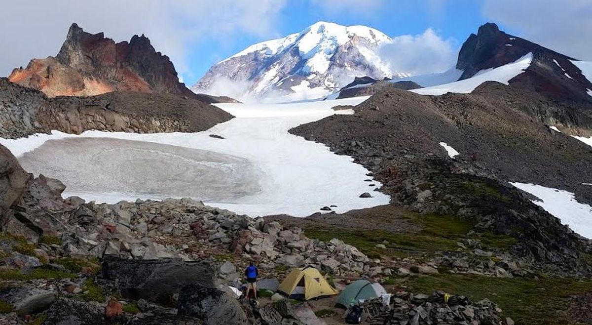
Glacier Basin: Roundtrip: 6.5 miles. Elevation gain: 1,600 feet.
This trail follows the main climbing route up on the northeast side of Mount Rainier.
Starting at the White River Campground, follow the chalky White River as it tumbles from the Emmons Glacier. After one mile, the trail intersects with the Emmons Moraine trail; stay right and continue climbing through sub-alpine forest a little over two miles into Glacier Basin.
Consider continuing on a side hike up a climbers’ trail to the ridgeline below Mount Ruth (8,690 feet). The trail climbs steeply to the east, and if you can reach the ridgeline, you’ll be rewarded with mind-blowing views of the Emmons, the largest glacier in the Continental United States.
Backcountry camping option: Glacier Basin.
Chinook Pass
Naches Peak Loop: Round trip: 3.5 miles. Elevation gain: 500 feet.
From kids to grannies, anyone can have a great time on this trail. It’s easy, but delivers great views of Mount Rainier, flowing fields of wildflowers and ripe huckleberries in late summer and early fall.
Park a half-mile west of Chinook Pass at the Tipsoo Lake parking lot. Hike the route clockwise to Chinook Pass until it intersects with the Pacific Crest Trail, then head southeast around Naches Peak. Once you reach the high point on the southeast shoulder, you’ll intersect with the Naches Loop Trail back to your car and also have fantastic views of Mount Rainier.
Consider a short climb up Naches Peak (6,452 feet) for a picnic and pictures.
John Nelson is an outdoors writer based in Seattle. Follow his blog at skizer.org.