National Guard sent to Sprague as water rises; Little Spokane River falls below flood stage
About 40 members of the Washington National Guard descended upon Sprague on Monday as water continues to inundate the town.
About a dozen structures have taken on water from the flooding Negro Creek, said Chris Canaday, Sprague’s public works director. The creek flows through Sprague and connects to Sprague Lake.
“It’s a losing battle,” he said.
On Saturday, the creek crested and sent water flowing down some of the city’s streets and into a few businesses. Randy Westfall, who owns the Sprague Motel and RV Park near the creek, said some of his rooms had water flowing through back to front and into his parking lot.
“See that over there?” he said, pointing to the office. “It was a river through there.”
For weeks many in the town 37 miles west of Spokane along Interstate 90 have been pumping water from their basements and helping to stack sandbags to divert water away from homes.
Trace De Garmo, a City Council member, said almost everyone with a basement had water seeping up from the ground.
“Right now, we’re at the mercy of the weather,” he said.
The creek, which normally runs along Second Street in downtown Sprague, has flooded lower-level pastures and farms, including a 50-acre alfalfa and hay field known as Terry’s Farm.
The water is being sent downhill toward Sprague Lake, which is backing up, De Garmo said.
“Now that we’ve got a breather from the worst of the streams, now we got the lake to worry about,” he said.
Water rose Monday morning then started to recede by the afternoon and evening. Residents expect it to continue to fall, but worry water levels could rise with impending rain.
While many homeowners worked to clear their basements of water, members of the National Guard filled sandbags and reinforced edges of the creek. Volunteers from the Washington Department of Ecology and Washington Conservation Corps built them Saturday.
“They came in and busted butt and caught us up,” Canaday said. “We had so many breaches that they caught us up on.”
Canaday has lived in Sprague since 1989 and only seen flooding this bad one other time – in 1997.
“It’s not quite as bad, but it’s close,” he said.
The town is accepting volunteers to help fill and place sandbags. It’s also asking anyone who has a PTO-driven water pump that the city can borrow to call city hall at (509) 257-2262.
St. Joe River crests
The St. Joe River in St. Maries hit major flood level on Sunday but crested at 38.4 feet, more than 6 feet above flood stage. The river hasn’t been that high since 1999, said National Weather Service meteorologist Jeremy Wolf.
Yvette Benham, who owns River Front Suites near the St. Joe in St. Maries with her husband, said the two sandbagged the hotel property Friday, as did many other homeowners and businesses in other parts of town. She said water came up over the road on Riverside Avenue Sunday night at around 10 or 11 p.m., but has started to recede.
“The front door is only 55 feet from the bank of St. Joe,” she said. “Thankfully, the water didn’t reach us.”
Perhaps worse than the St. Joe flooding is what happened to state Highway 5, which connects Plummer and St. Maries, Benham said. On Tuesday, parts of the road started dropping out between mileposts 4 and 5.
“There’s a section that’s almost completely gone,” she said. “The road is all crumbled.”
Due to this setback, it now takes her and her husband 90 minutes to commute to work – a drive that would normally take half an hour.
But despite the long commute and the water creeping up on their hotel, Benham said she and her husband are in good spirits.
“You keep a sense of humor,” she said. “There’s only so much you can do when nature takes its course.”
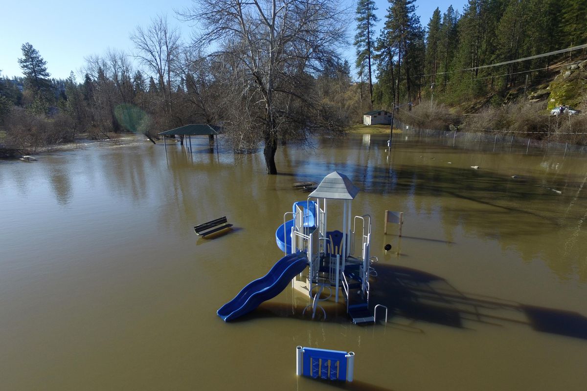
Little Spokane falling
The Little Spokane River no longer is flooding.
The National Weather Service reported that the river dipped below flood stage early Monday morning.
The Little Spokane was above flood stage all of Sunday and parts of last Wednesday and Thursday.
Meanwhile, the Spokane River remains above flood stage and isn’t expected to crest until Wednesday.
Two major highways closed
Two major highways in Northeast Washington are closed on Monday due to flooding and landslides.
U.S. Highway 395 from Colville to Kettle Falls was closed again on Monday after closures over the weekend due to high water in the Colville Valley.
One detour was on West Valley and Oakshott roads west of Colville. However, no trucks are allowed because of seasonal weight restrictions.
Oakshott Road can be reached off First Avenue in Colville.
Williams Lake Road was also being used as a detour for cars and empty trucks.
A signed detour was being used for southbound traffic, according to the state Department of Transportation.
Near Metaline in Pend Oreille County, state Highway 31 was closed due to slides. A detour is available on Sullivan Lake Road.
City road closures
Upriver Drive was closed Monday morning from Mission Avenue to Greene Street after rising waters covered the roadway east of Avista’s main campus.
Marlene Feist, director of strategic development for the public works and utilities department, said there’s still local access for residents, including the multiple apartment buildings along that road, but they’re routing them behind the flooded areas if possible.
“We expect the river to crest sometime (Tuesday) at this point, and we’re expecting more rain,” she said. “As long as there’s water covering the roadway, we’re going to need to keep that closed.”
South Riverton Avenue was also closed in the section that dips underneath the Greene Street Bridge near Spokane Community College, which caused Spokane Transit Authority to reroute routes 33 and 39.
They would normally head under the bridge on the way to the SCC campus. Instead, they’ll detour through the campus parking lot, said STA spokesman Brandon Rapez-Betty.
Army Corps helping
The U.S. Army Corps of Engineers has sent staff to the Inland Northwest to help shore up levees and do other emergency flood assistance.
The corps has been working on the St. Joe, Coeur d’Alene and Kootenai rivers in North Idaho and Callahan Creek at Troy, Montana.
One team was stabilizing 300 feet of a federal levee near St. Maries and 50 feet of the Shepherd Road levee, according to a news release from the agency.
Another team was staging rock for emergency use in Troy.
Other staff members were training communities for sandbagging.
The corps supplied two pumps for Kootenai County and distributed sandbags to the county and St. Maries.
More rain expected
Rain showers are expected off and on through the week. While rainfall amounts are expected to be on the lighter side, the new water will allow flooding conditions to persist longer, forecasters said.
The showers are predicted for Monday night into Wednesday and again on Friday. High temperatures should stay in the 50s with lows in the middle 30s to lower 40s.