North Spokane Corridor a harsh reality for homeowners, businesses still in its path
On Wednesday afternoon, Jim Ringo was halfway up a ladder leaning against his East Central home.
A mild wind kept the high sun’s heat to a pleasurable temperature, and the constant thrum of the nearby interstate accompanied Ringo in his maintenance work.
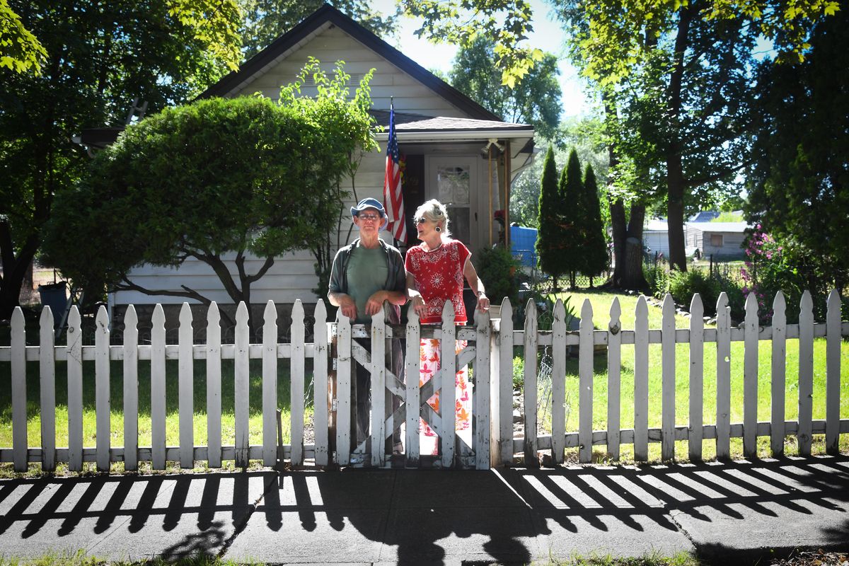
Since taking on the house following his mother’s death in 1987, Ringo has made it his own. New roof, new windows, new doors. The yard is lush and green, with soft grass, trees ringing the entire property and flowers peeking out here and there. He and his girlfriend of 22 years, Patricia LaVoie, sweep the sidewalk on a regular basis, from one corner to the next, their own contribution to keeping the neighborhood presentable.
Their place is almost the definition of quaint Americana, complete with a white picket fence and American flag.
It’s perfect, except for one thing. They’re among the last to live there. Across the street, an entire block is completely vacant, its 100-year-old houses demolished in the past decade. All that’s left are trees and weeds. Ringo and LaVoie have no immediate neighbors, only empty lots where neighbors once lived.
Their home, so well-tended, is an oasis. Vast stretches of this old neighborhood between East Sprague Avenue and Interstate 90 have been demolished to make way for the long-awaited north-south freeway.
Ringo, who’s lived in Spokane his entire life, still isn’t ready to move.
“They’re out of their minds,” he said of the construction of the North Spokane Corridor. “Spokane’s too small for it.”
Since construction began in 2001, 606 pieces of property have been purchased by the Washington State Department of Transportation, and 533 buildings demolished. Much of that destruction has been in Ringo and LaVoie’s neighborhood, even if the highway is still miles and years away from coming to this part of East Central.
But in its final rush toward its completion date just over a decade away, industrial land, neighborhoods and Spokane Community College’s parking lot stand in the freeway’s way. According to WSDOT, 119 properties remain in the freeway’s path.
“We bought a majority of the property under willing-buyer and willing-seller,” said Melinda Ziemann, the relocation supervisor for the eastern region of WSDOT. “Now we’ve entered eminent domain. We work alongside our displacees. It’s really important for the federal government that we do that.”
In short, the freeway is coming, and for the property owners who’ve yet to sell, the decision is no longer their own. The North Spokane Corridor’s $1.5 billion price tag is fully paid for, largely through the state’s gas tax. More than half of it is built, connecting Hillyard to Wandermere.
Lawmakers and generations of drivers have spoken: The time has come for the north-south freeway. Get out of the way. There’s a freeway to be built.
Slow process
Today’s highways are like yesterday’s rivers: wide, unimpeded, fast-flowing channels for traffic and freight.
In the time when pavement didn’t exist and all kinds of natural obstacles warded off long-distance movement of people and goods, rivers were the fastest means of travel, never mind the occasional waterfall or frothing rapids.
If that’s so, the North Spokane Corridor’s path so far makes sense. It meanders around north of the city, swinging east from Wandermere, then south, a wiggle west and a nudge east.
Crews are working right now to pull the freeway back west, over Freya Street near Hillyard. Soon, however, the highway will settle into a due-south course, straight and looking – on a map anyway – more like a gravity-driven waterfall. Even its eventual collision with I-90 looks like falling water hitting ground – it spreads out east and west a ways, to the interstate’s Hamilton interchange and the Sprague exit.
Like water, the freeway is pushing everything out of its way. And like water, it’s taken some time to carve its course.
The north-south freeway was first envisioned in 1946 as a way to ferry the growing ranks of residents in the northern suburbs to the city core. Studies followed: the Spokane Traffic Survey of 1946, the Spokane Urban Highway Capacity Survey in 1951, a preliminary “reconnaissance” report in 1955.
In 1956, the first plans for the north-south freeway were unveiled, showing an estimated cost of $13 million to complete the highway. It’s no coincidence that in the same year the Federal Aid Highway Act of 1956 was passed, paving the way for the Interstate Highway System.
At the time, Americans were completely smitten with the automobile, viewing it as a vehicle for freedom and prosperity. According to the Office of Highway Policy Information, which is part of the U.S. Department of Transportation’s Federal Highway Administration, Americans drove a total of about 340 billion miles in 1946. By 1956, that number had nearly doubled, to 628 billion miles.
The need for new roads was nearly unanimously agreed to, but the routes of the roads were not.
In Spokane, engineers drew up plans for two urban highways: I-90 and the north-south freeway, both cutting through densely populated areas.
Not everyone was pleased with the central routes, and state Rep. Margaret Hurley, who represented Spokane, pushed planners to build the highways around the city, not through it.
“We are afraid that a freeway that will rush traffic as fast as possible from Seattle to the Idaho border will not only do us economic damage but will ruin our beautiful city and cause a serious smog situation by 1975,” Hurley said at a meeting about I-90’s route at the Spokane Coliseum that drew 500 people in 1958, according to an article in The Spokesman-Review.
Her opposition did nothing, and I-90 was built at the base of the South Hill. The following decade, as planners drew up their ideas for the north-south freeway, Hurley and her Logan-area neighbors had better luck.
Plan B
In 1970, the state highway department released the Spokane Metropolitan Area Transportation Study, a report which had been promised for years. The SMATS map laid the roadway exactly where Hurley feared: along the Hamilton Street corridor in her own neighborhood, where more than 600 homes stood in its way, not to mention parks, schools and churches.
Hurley was incensed, and resistance to the freeway grew. Hurley spoke for the opposition from her place of power in Olympia, calling highway planners “devious, domineering and arrogant.”
The resistance won, and the state dropped its plans to run the highway up the Hamilton-Nevada-Helena corridor. Many figured the highway was killed for good.
It wasn’t. Plans and studies continued to be made. In 1985, the Spokane Regional Council identified the lack of a North Side highway as a major problem, and requested studies from WSDOT to look into building the road.
In 1991, WSDOT estimated the cost to build the north-south freeway at $651 million when it finally and officially dropped the Hamilton corridor as an option for the highway and looked east to a more sparsely populated area to build the freeway.
In 1997, a Final Environmental Impact Statement was done and approved by the Federal Highway Administration. No obstacles but funding stood in the way of the freeway, which the Legislature cleared in 1999 and 2000 by allocating $3.9 million for design work and $19 million for purchasing right-of-way. Another $1 million came from the feds as part of the National Corridor Planning and Development Program.
On Aug. 22, 2001, the official groundbreaking took place on the freeway’s first major section, from Hawthorne to Farwell roads. Since then, the project has continued steadily. The final piece of the funding puzzle came in 2015 when state legislators put $879 million toward finishing the southern half of the freeway.
Still, after decades of work and the outlay of hundreds of millions of dollars, for many the freeway remained imaginary and unlikely.
“A lot of people don’t believe it’s going to happen. But it’s going to happen,” said Kevin Brockbank, president of Spokane Community College. “We’re just dealing with the reality of that.”
On the bright side
For students at Spokane Community College, the Skyway is a term they may want to memorize.
It describes the final southern leg of the freeway, an elevated section that will fly over the Chief Garry and East Central neighborhoods, at times 60 feet above the ground. From the Spokane River to its terminus at I-90, the freeway will look something like I-90 downtown, just with fewer on- and off-ramps.
From the concrete clock tower on SCC’s campus, the view of the highway would be great, if there were a view. The clock tower is in the way, and will “very likely” be demolished, Brockbank said.
“That’s been something of a landmark. The idea in my mind is to replace it with another identifying landmark on our campus, another opportunity to give another identity,” he said. “I think we’re up to the challenge.”
When it comes to challenges brought by the freeway, there are many. The Skyway will go over the western parking lot, affecting 900 parking spaces. The current “face” of the campus is oriented west.
“As we put the freeway in there, we’re going to turn the face to Mission Street,” Brockbank said. “That will be a big change for us.”
Brockbank said he couldn’t talk much about his dealings with WSDOT, since discussions regarding the parking lot, clock tower and freeway are ongoing. But he said he was focused on the “opportunities it can create.”
“I think everybody has the expected concerns, but the reality is it’s going through,” he said.
He said there would be “educational opportunities” related to the highway, but said it was too early to describe what that may mean.
“Freeways go through a lot of different places and there’s a lot of great things that happen next to a freeway,” he said.
In with the new
Some of those great things are already known. The multiuse Children of the Sun Trail that will run along the freeway’s entire length, connecting to the Centennial and Ben Burr trails. And there are the vast warehouses already popping up near its interchanges, in an attempt to capitalize on the freeway’s potential as a conduit for freight.
In that sense, freeways can be great for economic development. But for the 21 commercial buildings that remain in its path, the future may not be so bright.
One of the more notable businesses is Pacific Steel and Recycling, a company that grew out of the American West’s fur-trading past. It was once called Pacific Hide and Fur, and occupied a building on Madison Street downtown abutting the elevated train tracks that now house the Steel Barrel Taproom, a high-end bar.
Others include Savage Wholesale Building Materials, Electrical Service Products, Jammin Auto & RV, Sharp-Line and many others.
Todd Rothrock manages a building owned by his mother that will be demolished for the freeway. Currently, it houses Elkay Manufacturing, Pilkington Auto Glass and Evergreen Gymnastics.
Rothrock’s family has owned the property there for a long time, and it used to run stockyards on the east side of the Freya bridge.
Rothrock hasn’t been holding out. He’s just been waiting for them to come to him, which finally happened.
Recently, he received a two-page document from WSDOT, and he’s filling it out: who owns what, the names of his tenants, whether they have long-term leases. His tenants do, and he knows the state will help find them new homes.
“We’re ready for it when it comes,” he said. “Let them throw us an offer and work through it from there. Our understanding is they’ve been pretty fair.”
Moving forward, with help
From her front porch, Anjeanette Silver will have a great view of all of it. The freeway. The Skyway. The long-gone neighborhood.
She lives in a house she bought on Fiske Street in 2004. Like Ringo and LaVoie, she’s watched as the neighborhood around her has come down.
“It’s so nice. I love it,” she said. “Compared to what it was like before, this place is heaven.”
Before the blocks were razed of houses that she described as largely run by slumlords, Silver recalled street fights that involved men with swastikas tattooed on their chests. It was frightening. Recently, her neighbors’ cars have been burglarized and she had all of her craft jewelry supplies taken from her garage, crimes she prefers to racist violence.
“My garage has been broken into so many times it’s insane. But it’s so much better now,” she said. She pointed to a chair on her front porch. “I get in that chair and think, I don’t want to move.”
Still, she knows she’ll have to move soon, regardless of how she feels.
“I just don’t want them screwing me,” she said, noting that she’s only had “vague contact” with WSDOT.
Without speaking about Silver’s case directly, Ziemann, the relocation supervisor for the eastern region of WSDOT, said people like Silver will hear from the state department soon. The remaining residences in the freeway’s path will be gone in a year, two tops. The businesses have four to six years.
“Our goal is to make it as least stressful as possible. We work really hard,” she said. “I’ve been stressing our heart on the whole thing. It’s stressful for a lot of people and that just breaks my heart.”
Hearts aside, the rules surrounding relocation and displacement of people are many. So much so, that Ziemann is wary to go over them, out of fear that they’ll be misconstrued, or that some minutiae will be missed. She’d rather people read the brochures on WSDOT’s real estate webpage.
The process is so complex that training relocation agents takes five years for them to be proficient. WSDOT’s eastern regional office has only three agents. Statewide, there are just three agents who are qualified to handle commercial relocation.
The long and short of it, though, is straightforward. Homeowners, renters, business owners and property owners all qualify for reimbursement and assistance.
Appraisals and comparable home sales are part of the equation when determining a “fair market value” for the house or property. All of this work is double-checked in Olympia to assure fairness.
“Nothing happens until an appraiser has been hired to appraise the properties. They walk it with the owner of the property. We make every effort to make sure they’re there and give them that opportunity,” Ziemann said. “By law we have to offer the fair market value.”
Beyond that, relocation agents help in finding new houses to buy, homes to rent and buildings to move a business to. Moving costs are covered within 50 miles.
“There are strict laws in what we can and can’t pay for,” Ziemann said. “But we assist in every way possible.”
Commercial relocations are more complicated, but generally the whole process takes up to six months. It’s a process that can be very difficult for people, especially those who have lived in a house for decades or who with disabilities, but Ziemann takes pride in her work.
“We work really hard,” she said. “We do a really great job of relocating people.”
Hard to let go
Louis and Debra Barro own two homes that are on the chopping block. A third home – the one they live in – will remain, but it’s just outside the zone of demolition.
They were approached about 10 years ago by WSDOT, and offered $82,000 for a house they own on Fiske, Barro said, but turned it down.
“It seemed to be low,” he said. “We’d gotten that house paid off and we thought we’d rent and be minus a mortgage in order to realize a gain.”
Barro, who spent his career at the Arc of Spokane, said the house was a retirement investment.
“We’re retired. This is the last go around, and we don’t have the means to invest very much,” he said.
Their investment turned out to be “problematic” after every other house on the block disappeared.
“We began to have it vandalized. It began to get pilfered for the metals in it. That turned out to be a fiasco, and had to have it remedied by repairs, and that was costly,” he said. “They broke window after window out of spite, it looked like. I don’t know what their grievance was.”
Finally, the Barros found renters, but even that didn’t work out too well.
“They were rather dismayed to rent it, considering its surroundings,” he said. “The guy who rented it was a roofer and got hurt and quit paying rent.”
Both Barro and his renter, Tony Darling, said the missed rents are being made up slowly but surely, but that’s just added to the stress of the home’s impending demise.
Darling, who lives in the house with his wife, Theresa, is worried that he won’t get any assistance from WSDOT if he’s not caught up on rent, so every two weeks he’s paying half the rent, with some extra to make up the debt he owes Barro.
“I want to move. I want to get to a better place,” Darling said from his front porch. “I wouldn’t mind living out in the country. This place makes you feel like you’re living in the country.”
Aside from the constant roar of I-90 just a couple hundred feet away, Darling’s right. Across the street, a vacant, lifeless block. His block has exactly one house: his. Turn any direction, nearly nothing.
Sometimes, however, visitors to his neighborhood give him a distinctly citified perspective.
“We’ve seen a lot crazy things. People sleeping on the corner,” Darling said. “We’ve met some nice people, too. I’ve been fixing up the yard. We’ve been working on making it look nicer.”
The Darlings’ yard is nice, much like their closest neighbors directly across an empty block: Ringo and LaVoie.
They, too, seem immune to the highway noise.
“It’s too quiet here,” Ringo said. “It used to not be so quiet.”
Ringo doesn’t see a need for the highway, but there’s more to their resistance to relocating. They feel like the offers they’ve got from WSDOT are too low. They don’t like the rules placed on the money they will receive. They worry that, considering the lien on the house, Ringo will walk away with debt and no home.
But in the end, they’re just going to miss the house, and the neighborhood.
“I hate to see it go,” LaVoie said.