After ‘chaotic’ final meeting Monday, redistricting commission sends final maps to state Supreme Court
OLYMPIA – Despite coming up short in its effort to redraw legislative and congressional maps before Monday’s deadline, Washington’s redistricting commission released its final maps late Tuesday, almost 24 hours past the deadline.
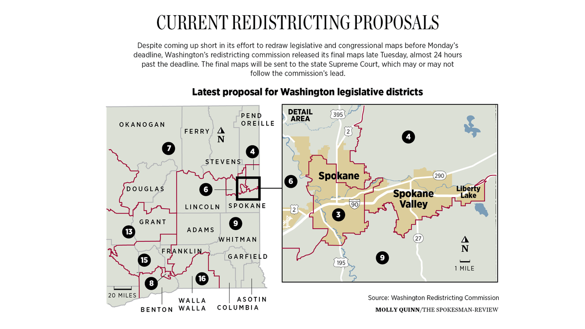
The final maps will be sent to the state Supreme Court, which may or may not follow the commission’s lead.
“These maps reflect the input of the thousands of people who took part in the process with us,” commission chair Sarah Augustine said. “It would be a shame to see these maps go unconsidered simply because the clock struck 12.”
The maps sent to the Supreme Court had consensus among the voting members of the commission, but they were not completed in time. The deadline for the commission to approve new maps was 11:59 p.m. Nov. 15.
The maps that will be decided on by the state Supreme Court for the 10 U.S. House districts and 49 state legislative districts will be in place for a decade
The commission’s final meeting Monday took place mostly behind closed doors and ended with a hasty vote just before midnight. At the time, it was unclear what the commission had voted on as no maps were immediately made public. The commission then admitted Tuesday morning it had failed to meet the deadline.
The Supreme Court on Thursday issued an order requiring Augustine to release a detailed timeline of the events of Nov. 15 and Nov. 16. It should include the timing of any votes taken by the commission, exactly what each vote was regarding and any other actions taken by the commission relevant to its obligations.
The timeline must be returned to the court by noon Monday.
Augustine told reporters she has had preliminary contact with the court clerk and has offered up all resources the commission has, including staff support.
‘Chaotic’ final meeting
In a Thursday news conference, the commissioners said their late-night vote Monday was on “a verbal agreement” on what the final maps would look like. Final maps were not done at that point, but the commissioners agreed on “a framework that you could immediately translate into the maps themselves,” Republican appointee Paul Graves said.
The commissioners acknowledged finalizing the maps took some time after the deadline, but they said no changes to the agreement they voted on were made after midnight. The only thing left to do was finalize some population balancing and the map boundaries, Democratic appointee Brady Piñero Walkinshaw said.
Democratic commissioner April Sims said the agreement they voted on “was very specific.”
All of the commissioners supported the final agreement and the final maps they released late Tuesday.
“While the homework was turned in late, it was completed,” Republican appointee Joe Fain told reporters Thursday.
Graves said the commission had set a 5 p.m. Monday deadline for themselves to have a final map, giving them plenty of time to discuss it and vote on it before the midnight deadline. However, when 5 p.m. came, they did not have an agreement, but were “very, very close,” Graves said. They decided to keep working.
The result was a “chaotic” meeting that went up until the last minute, he said.
“I wanted this to go very differently,” Graves said.
Most of Monday’s meeting was spent in what the commission called “caucus dyads,” which were groups of two who would work on either the congressional or the legislative map. Because they were meeting in two and not a majority of the group, they were under the impression it was not violating the Open Public Meetings Act.
The commission is subject to the law, which requires it to meet and make decisions in public. According to the law, public voting bodies can go behind closed doors for only select reasons, such as personnel matters, legal issues or security concerns. The commissioners did not explain how the mostly-private meetings complied with the Open Public Meetings Act.
Juli Bunting, executive director of the Washington Coalition for Open Government, said Tuesday it appears that the commission “very blatantly” violated the Open Public Meetings Act.
Sims said she had “deep disappointment and regret” that the commission was not able to work up to the high standard for transparency that it set for itself early on in the process. What happened Monday was a “mad rush to try to meet the deadline.”
What’s in their final maps
If approved by the state Supreme Court as currently drawn by the Redistricting Commission, the legislative districts in the Spokane area would see some dramatic changes.
The 3rd District, which currently contains downtown and the city’s core from the lower South Hill to Hillyard would contain most of the city precincts, including all of South Spokane to the city limits, downtown and areas north of Interstate 90 and much of northwest and north central Spokane city, including the Garland district and West Central. But it would not have Hillyard or the northwest tip of the city, including the Indian Trail area.
Graves said last week the county was part of an interesting phenomenon happening across the state. The downtown city grew more slowly while the surrounding suburbs grew more quickly. To account for that, the commissioners had to expand the 3rd District to meet the population requirement.
Graves said the most natural way to do that was to include the South Hill.
The 4th District would continue to have its largest population and voter base in Spokane Valley, Liberty Lake and Millwood, and would stretch north to the county line.
The 6th District, which for decades was anchored in the South Hill, will no longer include those precincts but will stretch across the West Plains to include Airway Heights, Fairchild Air Force Base, Medical Lake and city precincts near the Sunset Highway, plus northwest precincts of the city, Hillyard and the growing suburban development along North Division and Highway 395.
Sims said last week that much of what she did in her proposals for Eastern Washington was part of “a water balloon effect.” When commissioners change maps in one area of the state, there are significant impacts in districts across the state.
“Every decision has a potential conflict or impact,” Sims said Thursday.
The 7th District will add fewer North Spokane precincts to the sprawling district that covers much of northeast Washington along the Canadian border.
The 9th District would include Cheney and much of south Spokane County below the city limits of Spokane and Spokane Valley in a district that extends through the Palouse to the Washington-Oregon border. It would mean that two major state universities – Washington State University and Eastern Washington University – would once again be in the same legislative district.
Commissioners, lawmakers urge Supreme Court to adopt final maps
All of the commissioners urged the Supreme Court to adopt their final maps that they said were a product of historic public input. The commission received more than 2,750 comments on draft maps and more than 3,000 comments directly to commissioners.
House Speaker Laurie Jinkins, D-Tacoma, said in a statement she hoped the court takes up the commissioners’ maps.
“Whether they do or not, I trust the Court will adopt a map that honors the constitution, as well as the principles of fairness and equity while recognizing the political realities of the state,” she said.
House Republican Leader J.T. Wilcox, of Yelm, also urged the court to adopt the maps released by the commission.
“While I do not like some aspects of the Legislative District and Congressional District maps released by the Redistricting Commission, I respect the fact these maps were put forward with unanimous support of the four commissioners,” Wilcox said in a statement.
Senate Majority Leader Andy Billig, D-Spokane, said in a statement the map appears to have many features that provide fair and accurate representation, but he was concerned about a lack of a Latino-majority district in the Yakima Valley, which could be a violation of the Voting Rights Act.
“I hope the Supreme Court will closely examine this section of the map and use its authority to create a map that ensures Latino voters in the Yakima Valley can elect the candidate of their choice, as is required by federal law,” Billig said.
The Yakima Valley district became one of contention among the commissioners in the final weeks of negotiations. The Republican appointees both said last week they did not think a Voting Rights Act lawsuit would be forthcoming without that district, but the Democratic appointees did, releasing new maps last month to include that district. While he supports the final maps, Walkinshaw said one area he is still concerned with is Yakima Valley, saying there are real questions involving the Voting Rights Act.
S-R reporter Jim Camden contributed to this report.