Forecasters: Tropical Storm Nicholas forms in Gulf of Mexico

Associated Press
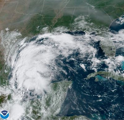
MIAMI – Tropical Storm Nicholas was expected to strengthen as it headed for the Gulf Coast on Sunday, threatening heavy rain and floods in coastal areas of Texas, Mexico and Louisiana.
Forecasters at the National Hurricane Center in Miami said a hurricane watch and storm surge warning were issued for a portion of Texas, while tropical storm warnings were issued for coastal areas of Texas. Nicholas is expected to produce total rainfall of 5 to 10 inches, with isolated maximum amounts of 15 inches, across portions of coastal Texas into southwest Louisiana on Sunday through midweek. The hurricane watch was issued for the coast of Texas from Port Aransas to Sargent.
The storm was expected to bring the heaviest rainfall west of where Hurricane Ida slammed into Louisiana two weeks ago. Although forecasters did not expect Louisiana to suffer from strong winds again, meteorologist Bob Henson at Yale Climate Connections predicted rainfall could still plague places where the hurricane toppled homes, paralyzed electrical and water infrastructure and left at least 26 people dead.
“There could be several inches of rain across southeast Louisiana, where Ida struck,” Henson said in an email.
Across Louisiana, 140,198 customers – or about 6.3% of the state – remained without power on Sunday morning, according to the Louisiana Public Service Commission.
Louisiana Gov. John Bel Edwards took to Twitter to urge people in the southern portion of the state to keep a close eye on the storm and be prepared for heavy rains and flash flooding.
The storm is projected to move slowly up the coastland which could dump torrential amounts of rain over several days, said meteorologist Donald Jones of the National Weather Service in Lake Charles, Louisiana.
“Heavy rain, flash flooding appears to be the biggest threat across our region,” he said in an email.
The storm has the potential to dump as much as 15 to 25 inches of rain in isolated areas either in southeast Texas or southwest Louisiana, he said.
While Lake Charles received minimal impact from Ida, the city saw multiple wallops from Hurricane Laura and Hurricane Delta in 2020, a winter storm in February as well as historic flooding this spring.
“We are still a very battered city,” Lake Charles Mayor Nic Hunter said.
He said the city is taking the threat of the storm seriously, as it does all tropical systems.
“Hope and prayer is not a good game plan,” Hunter said.
The center of the storm was forecast to pass near or just offshore the coasts of northeastern Mexico and South Texas on Monday, and hit south or central Texas on Monday night or early Tuesday. Its maximum sustained winds were clocked at 40 mph and it was moving north-northwest at 15 mph. Gradual strengthening is forecast in the next day or so.