More heavy rain, strong winds and dangerous surf expected in the West

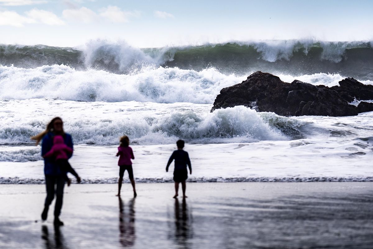

Tourists walk cautiously along Pfeiffer Beach in Big Sur, California, on Tuesday, amid a high-surf warning. Conditions remain potentially dangerous. MUST CREDIT: Melina Mara/The Washington Post (Melina Mara/The Washington Post)
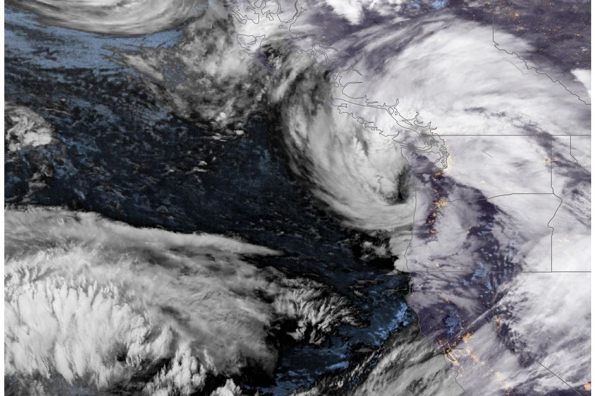
A strong atmospheric river was making landfall in the Pacific Northwest early Thursday and is expected to bring heavy rain, strong winds and potentially dangerous surf in areas from Northern California to British Columbia.
Atmospheric rivers are long, narrow plumes of water vapor in the sky that can bring adverse weather, such as downpours and strong winds, when they move over land. Along this one, which has a moisture connection spanning more than 6,000 miles across the Pacific Ocean, a strong storm has formed and is forecast to push ashore in north coastal Washington.
There, it brought heavy rain and strong wind gusts of up to 50 mph through Thursday morning.
Tens of thousands of customers were without power as of early Thursday in Oregon and Washington, and the number will probably continue to grow.
Winds in Astoria, Oregon, gusted to 61 mph Wednesday night, while gusts of 60 to 70 mph were recorded in mountainous areas of the state.
Weather advisories and warnings cover nine western states due to the storm barrage, which already caused considerable damage in Santa Cruz, California, on Monday. Heavy rain, strong winds and heavy mountain snow will cause dangerous travel conditions across the Pacific Northwest and Intermountain West through the weekend.
Large waves over 20 feet high were possible in north coastal Oregon and south coastal Washington on Thursday morning.
A lull in the rain and wind later Thursday gave brief respite before another surge of rain and wind slams into Northern California and coastal Oregon on Thursday night and Friday morning.
A high-wind warning covered Seattle, Tacoma and Everett on Thursday morning. The National Weather Service in Seattle advised people to secure loose objects and to prepare for power outages.
Strong gusts hit coastal Oregon and south coastal Washington, near and south of the center of the storm pushing ashore.
The strongest winds pushed inland later Thursday morning and afternoon, affecting Spokane, where a wind advisory was in effect until 3 p.m.
Blustery conditions were forecast in North Idaho and western Montana late Thursday.
Another round of strong winds is expected in southern Oregon and far Northern California late Thursday night and Friday morning. Areas from Crescent City, California, to Coos Bay, Oregon, may experience gusts of more than 50 mph.
Gusty conditions are then forecast to spread eastward across eastern Oregon, southwestern Idaho and northern Nevada throughout Friday.
Another round of gusty winds is forecast to move into coastal Oregon and Washington from Friday night into Saturday morning.
As several storms ride the atmospheric river through the weekend, copious amounts of rain will fall across the coastal Pacific Northwest.
Heavy rain will occur in pulses from Thursday through Sunday, with the heaviest amounts expected in a corridor from Klamath, California, through Port Orford, Oregon.
A surge of rain Thursday night and Friday morning is forecast to be followed by a slow-moving but intense area of rain from Saturday into Sunday morning.
There is a slight risk (Level 2 out of 4) of excessive rainfall in the region over the weekend, according to the National Oceanic and Atmospheric Weather Prediction Center, as the office in Medford, Oregon, warned that “several rivers are forecast to reach bank full or even flood.”
The rain is forecast to ease late Sunday.
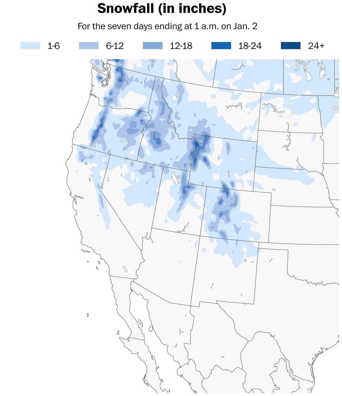
Heavy snow accumulations are forecast across the mountains of the Pacific Northwest and Intermountain West through the weekend, leading to dangerous travel conditions along pass roads.
The heaviest amounts are expected in the Cascades of Washington and Oregon, where reliable modeling suggests more than 6 feet is possible by Monday.
Accumulation will also be measured in feet across the Sawtooth Range of Idaho, the Tetons of Wyoming, the Wasatch Range of Utah and the Rockies of northern Colorado.
Cities such as Boise, Salt Lake City and Denver were forecast to generally avoid accumulating snow.
There is some light at the end of the tunnel. After a stormy weekend, the barrage of systems is forecast to end as the atmospheric river weakens.
Tuesday looks like a rare mostly dry day across the Pacific Northwest and Intermountain West.
Another system could approach Oregon and Washington on Wednesday, although it doesn’t look to be as intense as the current storm.
Drier-than-normal conditions are forecast in Northern California, southern Oregon and the Intermountain West during early January as storm activity shifts east.