Hail and heavy rain a risk as a stretch of severe weather begins for the central U.S.
A bout of severe weather will begin Thursday across central states and could last into early next week as the Lower 48 enters peak tornado season. Baseball-sized hail and an isolated tornado are possible in the Corn Belt on Thursday, with repeated rounds of strong to severe storms and flooding affecting the central and southern Plains both Friday and into the weekend.
More than 3 inches of rain are forecast to fall in parts of eight states through the weekend, including Oklahoma, Missouri, Kansas, Illinois, Indiana, Iowa, Texas and Michigan, potentially leading to flooding. Some of the heavy rain will fall in states that were lashed by a deadly storm earlier in the month, though this storm doesn’t look quite as intense as the most recent one.
Some of the same areas that will be affected this week have been hit by flooding and strong tornadoes repeatedly throughout March and April.
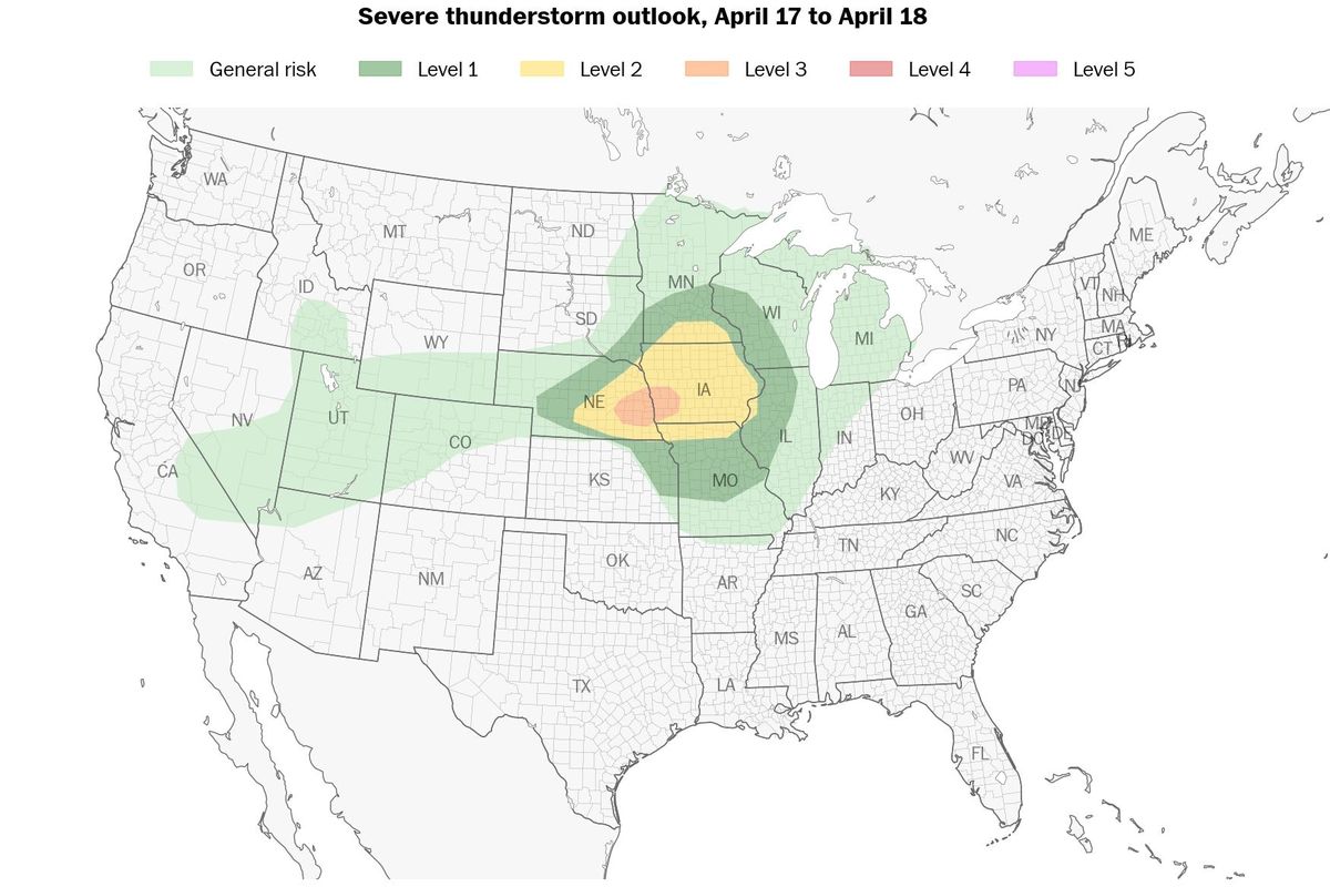
An enhanced (Level 3 out of 5) risk of severe weather has been drawn for parts of the Interstate 80 corridor in Nebraska and western Iowa for Thursday, and includes Lincoln, Omaha, Council Bluffs and Des Moines. There are also more expansive severe weather risks for Friday, Saturday and Sunday; Sunday specifically could feature a more pronounced risk of severe weather over the Ozarks, East Texas and the Ark-La-Tex region, which includes southwestern Arkansas, northwestern Louisiana and northeastern Texas.
There are signs that a break in the action could come Monday, but thereafter the overarching weather pattern could reawaken with sporadic severe weather across Texas and the southern Plains next week.
Thursday
The severe-weather risk on Thursday is mainly for large, destructive hail - perhaps to the size of apples, or even upward of 3 inches in diameter. It’s probable that only a few storms will form, but they could impact areas near the populous Lincoln-to-Omaha corridor in Nebraska, as well as folks along and north of Interstate 80 in southern and western Iowa.
Low pressure to the west is scooping Gulf moisture northward. That will provide fuel for a few thunderstorms to sprout during the mid-evening hours. Those storms probably will form along the leading edge of dry air from the west as it impinges on moisture to the east. That clash is what will brew storms.
Thunderstorm will tap into changing winds with height and will rotate. That’s why they’ll produce such large hail. There could be an isolated tornado near the Omaha area if there’s enough low-level moisture - but if the surface is too dry, cloud bases will be higher and it will be tough for rotation to snake its way to the surface.
That’s why hail, and not tornadoes, remains the primary threat.
Those storms will push east into Iowa during the evening and last through about midnight, perhaps bringing a risk of large hail to Des Moines as well.
Farther north, additional storms will blossom along a warm front in southern Minnesota and northern Iowa. Those cells will produce mainly quarter-sized hail, because they’ll be rooted in milder air above a shallow cool, dry layer near the surface.
Friday
On Friday, the risk area stretches from Detroit and Chicago all the way to west of Dallas, and includes Indianapolis; Springfield, Illinois; St. Louis; Joplin, Missouri; Oklahoma City; and Wichita Falls, Texas. For now, it’s a Level 2 out of 5 risk in this region.
A cold front will be sagging southeast across the area. Ahead of it, sufficient warmth and moisture will exist for storms.
Mid-level winds will be parallel to the front - out of the southeast - however, which means storms won’t be pushed off the front. Instead, thunderstorms will continue to blossom but sit on the front, merging with neighboring cells. That will cut back on the tornado risk but will lead to increased flooding and damaging wind risks. That will be especially true where storms repeatedly move over the same areas.
There will also be some undercutting, which occurs when cool air from the north slides beneath thunderstorms along the front. That also will cut back on the tornado risk. As a result, the threat of any tornadoes will be low.
That said, Friday evening could kick off a potential flood episode from eastern Oklahoma to northwest Arkansas - the same areas that will be drenched over the weekend.
Saturday’s setup covers areas similar to Friday’s, but shifted a tad to the southeast with the slowly advancing front. At this point, the Dallas-Fort Worth area is in the risk zone. Damaging gusts and some hail are possible anywhere in the risk area, but once again heavy rain will be a growing concern.
Waves of moisture will propagate northeastward along the front, and it’s not out of the question that some areas will see 3 or 4 inches in a single day in which thunderstorms repeatedly strike.
- - -
Heavy rain brings flooding risk
Repeated rounds of storms are expected to dump 3 to 6 inches of rain from Oklahoma to northwest Arkansas and Missouri through Monday, drenching already-sodden soils and leading to more flood issues.
From Arkansas to West Virginia, soils remain waterlogged and the Mississippi and Ohio rivers are still swollen. More than 20 rivers in the region are in moderate or major flood stage.
Parts of Kentucky and western Tennessee have received more than two times their average rainfall over the last 90 days, though the heaviest rain from the upcoming storm is expected to fall to the west of these places.
Some of the rain, however, will fall in western parts of the Corn Belt that are abnormally dry or experiencing drought and may prove beneficial.