Off-road vehicle trail in North Idaho sparking controversy
A fight has been brewing in North Idaho over a stretch of road pockmarked with pits, boulders and other obstacles that off-roaders love and conservationists loathe.
Known as the Roller Coaster Trail, it sits on Bureau of Land Management property in the St. Joe Mountains south of Pinehurst, in the West Fork Pine Creek drainage.
It has gained notoriety as a challenging, man-made playground for drivers of full-size off-road vehicles, and those who love it say it presents technical challenges they can’t find elsewhere.
But the trail’s future is uncertain.
The Bureau of Land Management released an environmental assessment last month that recommends removing the obstacles, saying they were built without proper analysis of their impacts on wildlife, the nearby creek and the surrounding landscape.
That comes amid a years-long access disupte over an old road that’s used to get to the trail. A landowner has blocked the road for years, and the off-road club North Idaho Trailblazers petitioned to have Shoshone County validate the road. The county declined, and the fight wound up in front of the Idaho Supreme Court, which ruled in June that the road is public but that it wasn’t in the public interest for the county to validate it and take ownership of it.
Since the ruling, the Trailblazers have been trying to get the county to agree that it’s a public road and enforce it. Meanwhile, the landowner, Joe Avery, is keeping it blocked.
Both the access fight and the BLM’s proposal to dump the obstacles have off-road enthusiasts feeling like they’re fighting tooth-and-nail for a place they think is special. It has also drawn the attention of the national off-road group Blue Ribbon Coalition.
Paul Loutzenhiser, of the North Idaho Trailblazers, said the BLM’s environmental assessment is somewhat encouraging. In addition to considering removing the obstacles, the document mulls a future in which the obstacles are maintained and the course remains a draw and a certain kind of challenge for off-roaders.
“It’s a technical experience,” Loutzenhiser said. “You go about 2 mph while trying to navigate a challenge, whether it’s rocks, logs, a dirt barrier of some kind.”
But opponents of the trail are worried about the continued impacts of the off-road playground, such as erosion, noise and traffic going up the roads to the trails. Many would like to see the obstacles get torn out and the trail turned into a regular road fit for vehicles that aren’t modified Jeeps.
That’s what Avery would like to see.
“It’s supposed to be a motorized acccess for everybody to use,” Avery said.
Road becomes trail
The origin of the Roller Coaster trail goes back to 1999, when the BLM decided it needed a new route into the West Fork Pine Creek drainage.
A primitive road at the bottom of the drainage was taking a beating from recurring storm damage, so the agency crafted a plan to build the new route, which goes on Langlois Road and climbs through the mountains before dropping into West Fork Pine Creek.
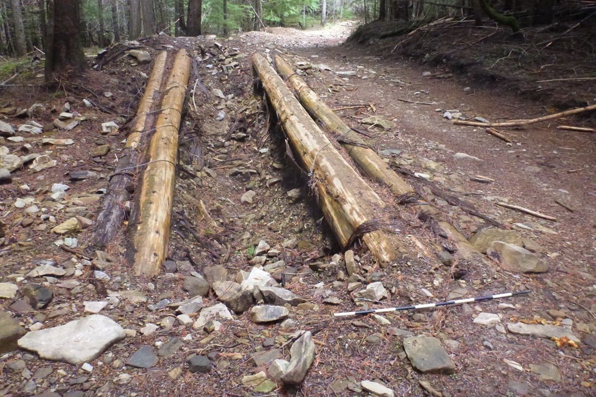
As part of the move, the old road along the West Fork of Pine Creek was meant to be decoommissioned. BLM staff built earthen barriers meant to keep people from using it. Jonathan Stein, an outdoor recreation planner for the BLM, said the barriers consisted of a series of about 50 humps.
But officials never formally decommissioned the road. In the 2007 Resource Management Plan, it was included on maps as a road that was deemed suitable for motorized use.
A few years later, the BLM seemed to endorse its transformation into a Jeep trail. In 2010 and 2011, the agency worked with the North Idaho Trail Blazers and the Idaho Department of Parks and Recreation to work on the earthen barriers and create structures that have made the trail so popular. More work happened after 2018, when Loutzenhiser’s group got a volunteer agreement with the BLM to do more maintenance.
BLM’s tune changed after 2019, however. The environmental assessment says officials noticed in 2019 that more structures had been added to a .8-mile section of the route, including “excavated pits, large boulders, cut and cabled lags as well as extensive earth work to armor the structures,” according to the environmental assessment.
Stein said there has been no documented environmental analysis for the work. Loutzenhiser disputes that, saying a BLM employee told him a categorical exclusion applied to the work. But Stein said the BLM has no record of a categorical exclusion being completed for the trail.
Stein said BLM started work on an environmental assessment last fall after people both opposed to and supportive of the trail urged the agency to do so.
The environmental assessment signals that BLM’s preference is to get rid of the structures and return the road to a standard width. That falls short of what some conservationists say is the best plan – getting rid of the structures and obliterating the road for good, letting it go back to its natural condition.
Randy Fox, of the Idaho Conservation League, said his group would rather have seen the road obliterated completely. He said there are erosion issues in the area and sediment that’s going into West Fork Pine Creek and other streams.
He added that the lack of environmental analysis before the structures were built is a problem.
“This wasn’t looked at at all, and the environmental consequences of that are unknown other than what we see on the ground now,” he said.
Loutzenhiser disagrees, and quibbles with the idea that the BLM wasn’t OK with the creation of some of the obstacles. He also argues that there aren’t any similar opportunities around because most similar trails are limited to smaller UTVs and ATVs.
His group prefers the other option analyzed in the document, which would keep the structures in place and allow for periodic maintenance. On a recent trip to the trail, he noticed a few logs that should be re-anchored.
A public comment period is open on the BLM’s environmental assessment until Aug. 13. Stein said he expects to see a final decision later this year.
No matter the decision, Stein said the agency won’t close the area to motorized use. He also said the final decision may not be as simple as picking one option or the other. It might be a mixed bag.
“It doesn’t have to be black and white,” Stein said.
Access fight not over
The BLM’s decision won’t resolve the access dispute.
Off-roaders have used three routes to get to the trail. One way goes up the Latour Creek drainage and around Latour Peak. Another uses the BLM’s official access to West Fork Pine Creek, the Langlois Road.
Both are longer than the route at the center of the access fight – the one that follows the old road along the main branch of Pine Creek, beginning at the end of the asphalt on West Fork Pine Creek Road south of Pinehurst.
The road passes through Avery’s property and land owned by the John Hancock Life Insurance Company before hitting BLM land. After a short ways on the BLM land, it meets the Roller Coaster Trail, which follows the West Fork.
Avery started blocking it during the pandemic. He said the BLM had previously asked him to allow smaller vehicles like motorcycles and ATVs to use the route, but that after a glut of Jeeps and other full-size vehicles started using the road he decided to block it.
“We just got swarmed with everybody during Covid,” he said. “We got tired of it and I blocked the road.”
Since then, the off-road crowd has been fighting to get it back open. They prefer that route to the Roller Coaster because it’s more fun and is usable when there’s snow on the ground, Loutzenhiser said.
Loutzenhiser petitioned Shoshone County to validate the road in 2022. They argued that minutes from a county meeting in 1909 as evidence the county had declared the road a public highway. The commissioners declined to validate it, which would have amounted to a declaration that it’s a county road.
When the case reached the Supreme Court, the justices agreed that the 1909 records establish the route as public, but also agreed that the county was right to decide that validation was not in the public interest.
That left the old road in a state of legal limbo. Avery has kept the gate in place. Meanwhile, Loutzenhiser has been trying to use the Supreme Court decision to get the county to remove the gate. A meeting is scheduled with the Shoshone County Commissioners on Tuesday.
If Loutzenhiser is successful at getting the county to act, a separate battle with the BLM may be looming.
The agency’s most recent maps don’t show the creek bottom road as a motorized travel route and Stein said the area is closed to motor vehicles. He said that’s the result of updates and corrections to the agency’s 2007 Resource Management Plan.
It is shown on a map from the 2007 plan as an “unimproved road.” Loutzenhiser said because that’s the only map that’s gone through the full environmental review process, it’s proof that motorized travel should be allowed there.