Temps cool a bit with chance of wet weather before heating up again
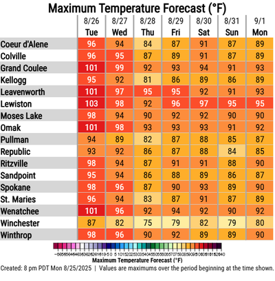

Temperatures are expected to dip into the 80s starting Wednesday and bring with them a chance of thunderstorms after several days of scorching highs that hit triple digits in parts of the Spokane area, according to the National Weather Service.
Temperatures are expected to be in the upper 80s to low 90s Wednesday before cooling down to the low to mid -80s Thursday. It heats up again Friday to Tuesday with highs in the mid-80s to low 90s, according to Miranda Cote, meteorologist at the National Weather Service Spokane.
Cote said 80 degrees is the normal high this time of year. The high temperature was 90 degrees Tuesday at the Spokane International Airport after the previous two days hit the mid- to upper 90s. Felts Field in Spokane reached 101 degrees Monday, according to Cote.
Moisture that has been lingering for several days in Oregon and southern Idaho pushed north to areas like the Cascade Mountains, Cote said. Storms are possible Wednesday and Thursday in Eastern Washington and North Idaho, with the best chance, or 30%, coming Wednesday night and Thursday morning.
Any rain that does fall should be minimal, Cote said.