Snowiest October day on record causes crashes, falling trees, power outages
Spokane was pummeled with a record-breaking 6.2 inches of snow Friday – the most to fall in the city during October – leading to slick roads and thousands of residents without power.
Snow began to fall midmorning and accelerated to an inch-per-hour in some locations, the National Weather Service reported.
The storm marks the second year in a row that Spokane has been hit by a significant October snowstorm.
As of 4 p.m. Friday, there were already around 4.7 inches of snow recorded at the Spokane Airport. By around 7 p.m., the National Weather Service said on Twitter that 6.2 inches had fallen. The Oct. 23 record for snow was 0.2 inches.
Before Friday, the snowiest October day on record was Oct. 22, 1957, when 5.9 inches fell. The second-highest snowfall was Oct. 8, 2019, when 3.3 inches fell.
As of 6:30 p.m., most of Spokane was recording between 4.4 and 4.8 inches of snow, according to the National Weather Service’s website.
At least 15,000 people across the Inland Northwest were without power after utility lines were snapped or disrupted by tree limbs heavy from snow and leaves.
Meanwhile, officials warned that Friday’s evening commute would be slow and slippery.
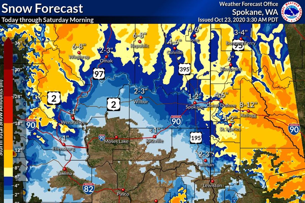
The storm was expected to dump 1 to 2 inches of snow on downtown Spokane and 3 to 5 inches to higher elevations like the West Plains and upper South Hill, according to Ron Miller, a meteorologist for the National Weather Service in Spokane.
“We’re still looking at quite a wide range of accumulation depending on where you live,” Miller said.
Snowfall was expected to be heavier to the north and east of Spokane.
Coeur d’Alene was projected to see between 4 and 6 inches of snow, as was Colville.
Although almost within sledding distance of downtown, the upper South Hill can receive 50% or more snow than downtown over the course of a winter, based on its elevation alone.
“These storms where the temperature is hovering right around 32, it makes all the difference,” Miller said.
The snow brought potential for downed trees, many of which have yet to shed their leaves and could bring power lines down with them.
“It’s really tough to tell; it just takes a perfect combination of temperature, the leaves, the air, the snow, to get the right stickiness factor,” Miller said.

Washington State Patrol Trooper Jeff Sevigney said there were slowdowns and crashes throughout the greater Spokane region. He urged motorists to drive slowly or stay home if possible.
“Most of these collisions were caused by folks just going too fast for the conditions,” he said.
Sevigney said he did not have exact numbers on how many more collisions there were than normal, but said they were causing significant issues on state roadways.
He said as of Thursday afternoon, there were no serious injuries or deaths reported.
“If folks don’t need to go out tonight, now would be a good time to stay in and watch a movie,” he said.
Spokane County Sheriff’s Office Spokesman Mark Gregory said deputies had seen an increase in collisions due to weather conditions. He said between 10 a.m. and 2 p.m., there were 35 collisions, though not all of them are necessarily related to weather.
He urged drivers to wipe down both headlights and window shields before driving, leave space between cars and go slowly.
“Give yourself a little extra time,” he said. “That way, you’ll get there, instead of having a collision and ending up there late or injured.”
He also noted that even drivers who have 4-wheel drive can have trouble, and urged all drivers to be cautious.
“Four-wheel drive helps you get going better, but it doesn’t help you stop any better,” he said.
Those planning air travel also saw some impacts from the weather. On Thursday, the airport warned travelers on Twitter to be prepared for adverse weather conditions, and a few flights were delayed or canceled Friday.
Tire shops and hardware stores have also seen the impacts of the storm.
Nine trees fell into the city of Spokane right of way and were moved during the storm Friday.
Public Works Director of Strategic Development Marlene Feist said city crews were geared up ready to address any additional fallen trees and snow crews were prepared to plow arterials throughout the night as well.
Steve Liberty, owner of Liberty Tires in Spokane, said the number of customers had tripled in the past few days, with around 80 people a day dropping by or calling in to request a tire change after the forecast came out.
“We’re slammed,” he said.
He said the tire shop normally doesn’t see a rush until after Nov. 1 and it usually extends into the holidays. The shop is scheduling out tire appointments into next week and many people who usually procrastinate until the holidays are asking to have their tires changed now.
“It’s way earlier than normal,” he said.
Larry Myers, owner of River Ridge Hardware on Garland Avenue in Spokane, said the store had seen an increase in demand for supplies since the National Weather Service storm warning went out. He said the storm caused an increase in the sale of winter supplies, but the demand has been elevated for weeks as people stock up on whatever supplies they can buy ahead of time.
“They’ve seen it with toilet paper,” he said. “They don’t want to be in the middle of winter and be out.”
He said the store briefly ran out of faucet covers after a rush of customers, and it ran out of pallets of pellets and can only sell them by the bag. He said purchasing supplies is a daily task because hardware stores suppliers are also stretched thin, so sometimes it’s challenging for him to get restocked quickly.
He said the rush of customers purchasing winter supplies and snow shovels this year came a little earlier than normal, but he stocked up early knowing that a storm, or a jump in demand caused by COVID-19, was likely coming.
In a news release Thursday, Avista Utilities said it had fleets prepared to respond to storm damage. Restoring power, if it’s lost, will be critical as temperatures plummet.
Morning low temperatures on Sunday and Monday are predicted to be 11 degrees, which would be records.
The previous record low at Spokane International Airport on Oct. 25 was 12 degrees, set in 1919.
Any snow that sticks Friday night and Saturday morning will likely stay through the weekend and early next week.
Miller said the early snowstorm is not the end of autumn weather. Temperatures are expected to reach around 50 degrees by Thursday, he said.