Sandpoint firm shows real estate in 3-D

In a tougher real estate market, a new Sandpoint company is banking on its 3-D online mapping tool giving agents a technological edge.
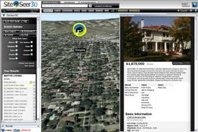
GeoData Technologies, formed around a computer application allowing agents or potential home buyers to virtually explore property listings or communities by overlaying information on aerial images, recently unveiled its SiteSeer3D product at a national Realtor convention.
The company plans to target multiple listing services, brokerages and franchises and expand its offerings beyond the Idaho and Spokane-area markets, directors said.
“If the market goes up or down, the people that are left are going to want to have the best tools in-house to do it,” said Jared Yost, director of technology. “And in a tough situation, the better your tools are, the better you’re going to do.”
The SiteSeer3D technology was developed by Sandpoint-based Black Diamond Engineering and Tour Real Estate Inc., of Boise.
The founders of GeoData this month started a separate company that employs three and is receiving off-site assistance from Spokane technology-business incubator Sirti.
3-D mapping tools, such as Google Earth and Microsoft Virtual Earth, and “mashups” that overlay crime, traffic or other data on maps have become a Web staple.
But GeoData stands apart, Yost said, because it compiles data and up-to-date images into a system that may be branded with an agent’s information.
Users may search listings by criteria such as price or size, or look for property near landmarks.
They may “fly” between sites on the map, turning on parcel boundaries, roads and other features. Agents can give guided tours or let clients look on their own.
GeoData boasts SiteSeer3D can shorten sales cycles and eliminate unnecessary driving.
The company uses software by Chantilly, Va.-based Skyline Software Systems Inc. to provide the basic 3-D globe application.
About 72 real estate agents and brokerages use the product, holdovers of a beta test, Yost said. Multiple listing service or brokerage customers would pay an undisclosed yearly subscription for the tool, the cost of which would be added to agents’ technology fees, said Ginger Petty, co-founder and marketing director.
GeoData works with the Intermountain MLS in the Boise area, and is looking into arrangements with a handful of others, Petty said.
Spokane’s Best Real Estate has offered SiteSeer3D on its Web site since June, said co-founder Leigh Wilson.
While customers haven’t specifically asked for the product, they find it handy for tasks such as checking out neighborhoods or seeing if a house is adjacent to a major road, she said.
“It really just saves them a lot of time and us in previewing” locations, she said.
SiteSeer3D created a similar product showing hiking trails and other information along the International Selkirk Loop, www.selkirkloop.org.
But it plans to focus on real estate as GeoData leaders refine its marketing strategy, directors said.