Getting There: Maple Street is trip down memory lane
Maple Street has a long memory.
The South Hill stretch appeared in the pages of the Spokane Daily Chronicle when streetcars were the preferred way to get around, and roads were swept for bicyclists and horses – not cars, whatever those were.
Snug on the second page of the July 12, 1898 edition, between a small item on an “excursion for Spokane business men to Lewiston” to investigate the construction of a rail line, and another more inconsequential, questionably newsworthy brief about a man named Herbert McBroom, who intended to “go to camp for the remainder of the summer” on Spirit Lake, there Maple sat.
“The people who live on south Maple Street are rejoicing,” it read. “The rocks which have been the grief of wheelmen and horses for several years have been cleared away by the street department and now Maple is one of the smoothest thoroughfares in the city.”
Oh, for the days when bicyclists and equestrians were the main users of Spokane’s roads.
Recently, the city of Spokane has been doing some much-needed maintenance on the South Hill one-way couplet of Walnut and Maple streets between Fourth and Ninth avenues. A good amount of pavement was ground away on Walnut, revealing bricks those “wheelmen and horses” likely traversed. Smooth new asphalt overlays the route again, recasting Spokane’s self-imposed reputation of a rutted city, pocked by potholes.
The same type of maintenance begins today on Maple, the uphill half of the couplet. The road will be open, but motorists can expect delays.
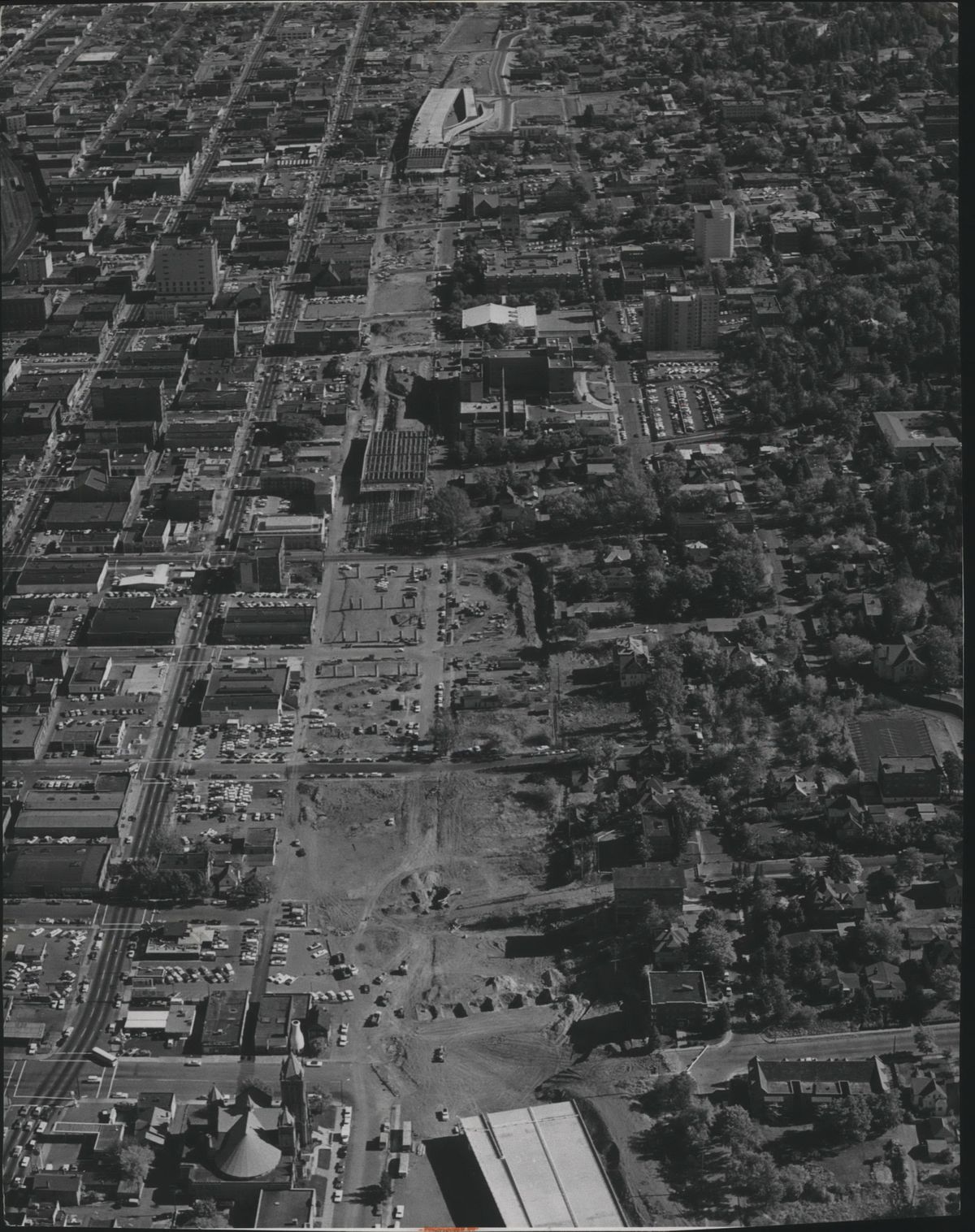
The Maple we know is very different than what early commuters would recognize: The road was transformed more than 50 years ago as a direct consequence of Interstate 90’s construction, when city planners unveiled the “Maple-Walnut-Cedar street modernization project.”
Before the freeway came along, the primary route down the western side of the South Hill was Cedar Street. You can still feel this natural path: Drive north on High Drive; it flows into Cedar, which flows into Riverside Avenue. It was a nice route for motorists. High Drive had been a fully developed road since 1918. And Maple had a bothersome streetcar running on it between Fifth and 14th avenues.
But in 1966, the car was dominant, the streetcar gone, the freeway was coming, and Cedar was insufficient for what the road planners envisioned.
Though construction of the interstate had started in 1956 as part of the Eisenhower-era Interstate Highway System, the section between Cedar and Jefferson was slated to be built in 1967. The plan for the “East-West freeway” would “close Cedar to through traffic,” according to a May 1966 Chronicle article. State highway engineers, who were in charge of Interstate 90’s construction, said the “city should coordinate the realignment of the streets with the freeway construction.”
The city did, and released its plans. Instead of going down the hill on Cedar, northbound, downhill motorists would jog west at 12th Avenue, where Maple and Walnut Street would pair off as one-way couplets – perfect for the freeway’s on-ramps that would be built at the hill’s base.
There was one complication: people lived in the way of the realignment. Maple and Walnut, like Cedar, were part of the street grid, and squares filled with homes were in the way of the wiggle.
A woman referred to only as “Mrs. Byron S. Howard” in both The Spokesman-Review and Chronicle lived at 1409 W. 11th Ave. and said the city just sprang the news of her home’s demolition with no warning.
“Some of us have spent a great deal of money improving our property,” she said at a meeting where the plans were unveiled by Glen Yake, the city engineer. “I don’t see why we couldn’t have been warned a little before the money was spent.”
Paul White owned two properties that would be demolished – an apartment building at 1528 W. 10th Ave. and a duplex at 917 S. Maple St. – and was “appalled” by the project and opposed to taking properties off the tax rolls. White took his fight all the way to Superior Court, where he in argued in January 1968 that the city only offered him $26,500 for properties worth $60,000.
Regardless, when the government wants to build a freeway and its related roads, it builds a freeway and those roads.
In October 1968, the 1.14-mile-long, $230,000 “Maple-Walnut-Cedar connection” was complete, and a 105-foot-long ribbon was strung “from the east side of Walnut across a large traffic island to the west side of Maple” to be ceremoniously snipped.
Yake, the engineer, was pleased.
“The project is now being used by vehicles and is proving very valuable in helping move traffic between the downtown area and the Southwest section of the city,” he said. “This is another important step in our continuing program to meet the rapidly growing traffic demands in our city. We are confident that our long-range plans, which include this project, will provide a street system that will prevent many of the problems other cities are experiencing.”
Fifty years later, the Maple-Walnut-Cedar corridor carries upward of 16,200 vehicles a day, equivalent to traffic loads on Southeast Boulevard and Grand Boulevard, and surpassed only by the Ray-Thor-Freya, the busiest route off the South Hill.
With the new pavement, motorists can expect many more years commuting on the route. As an established bikeway, so can cyclists.
Horses and streetcars, however, are out of luck.
Spokane’s many car-less bridges
Last month, the Post Street Bridge was closed to cars after a structural analysis showed the old bridge couldn’t handle the pressure anymore.
To that we say, welcome to the long list of auto-free spans in the city.
There’s the University District Gateway Bridge, everybody’s favorite new cable-stayed arch bridge. There’s the Iron Bridge, a 560-foot long railroad bridge that went out of commission 45 years ago and was paved in 2012 as a connection to the Centennial Trail. There’s the half-wooden, half-steel-paneled Don Kardong Bridge, connecting Gonzaga University to the University District, that offers an enviable choice to all: uneven wood or slippery steel. There are the three Howard Street bridges in Riverfront Park, which the city is rebuilding as a promenade. There’s the Sandifur Bridge, everybody’s favorite open-spandrel arch bridge – second only to the Monroe Street Bridge, of course.
There are the three claustrophobically caged pedestrian bridges over I-90. And, of course, the two Riverfront Park pedestrian bridges, one of which was closed completely because it was found structurally unsound, just like the one on Post.
What gives can also take away.
The city plans to replace the Post Street Bridge with a $26 million crossing capable of carrying cars, but the project has been dogged by higher costs and delays related to steel tariffs, labor and lumber costs. Two years will pass before motorists will cross this way again, by which point maybe no one will care anymore, and maybe, just maybe, the city will reserve it for cyclists and pedestrians.
Pedestrian deaths rise statewide
New data from the Washington State Department of Transportation shows pedestrian deaths continuing to rise in Washington.
From 2014 to 2018, total traffic deaths involving people walking and biking increased 50%, from 82 to 123. A large majority of fatalities – 87% – occur on roads with posted speeds of 30 mph or more. About 61% of fatalities occurred on city streets.
Finally, about 59% of fatal and serious injury crashes occurred in neighborhoods with higher poverty levels than the state average, places that have less pedestrian and cycling infrastructure.
Children of the Sun workshops
If you haven’t explored the Children of the Sun Trail that abuts the completed section of the North Spokane Corridor, you’re missing out on a long, quiet, paved trail. Don’t expect the solitude to last.
WSDOT is holding a series of “charrettes,” or workshops, to figure out where and how to build the rest of the trail, which will eventually connect with the Centennial Trail, and nearly the Ben Burr Trail.
To share thoughts and participate in the planning process, you can attend one of the two workshops listed below. The workshops are intended with families in mind, and a child-friendly environment with a play area will be provided. The workshops:
June 22 from 10 a.m. to 2:30 p.m. at the Southeast Day Care Center, 2227 E. Hartson Ave.
July 13 from 10 a.m. to 2:30 p.m. at Sheridan Elementary School’s commons, 3737 E. Fifth Ave.
In the city
Napa Street between Main and Sprague avenues will be closed today through Friday, June 14, for work related to the $15.8 million stormwater project in east Spokane to construct a 200,000-gallon sewer tank and a 1.4-million gallon tank.
Similar work in Peaceful Valley will affect the intersections of Clarke Avenue and Cedar Street, and Main and Cedar. Detours and flaggers will be in place.
Continuing work on the city’s largest stormwater tank near the downtown Spokane Public Library will close the right lane of Spokane Falls Boulevard between Post and Monroe streets beginning today through Friday from 6 a.m. to 2 p.m.
In the county
A roundabout on Aero Road and Westbow Road is being paved. The south leg of the roundabout will be closed beginning today. Detours are in place and motorists can expect delays.
Work on Bigelow Gulch continues, with clearing, grubbing, house demolition and the addition of culverts, guardrail and pavement. Work runs from Argonne to Evergreen roads. Speed limits are reduced to 35 mph.
A roundabout is being built at Carnahan and Glenrose. Twenty-first Avenue is local access only. Work continues on the project’s first phase, which is northeast of the existing intersection.
Work to improve pedestrian safety on 57th Avenue continues, with the installation of marked crosswalks and refuge islands.
WSDOT work
Westbound I-90 travelers can expect some delays today. From 8 a.m. to 4 p.m., westbound I-90 approaching exit 231 will be reduced to a single lane, which will detour through the Tokio Weigh Station interchange before returning to the highway.
The Tokio Weigh Station will also close today to help relieve congestion at the interchange.
The temporary detour will allow crews from WSDOT to inspect the Danekas Road overpass, struck by a tall truck on May 21. The northbound lane of Danekas Road overpass remains closed. An automated traffic signal directs alternating directions of traffic across the bridge.