Getting There: New route planned to ease congestion, fuel development in West Plains

One option for dealing with increasing traffic and congestion in the booming West Plains was to expand Highway 2, turning it into a seven-or-so-lane monstrosity ferrying traffic through the western periphery of Spokane, a slice of Kalispel tribal property and the heart of Airway Heights.
Ultimately, though, that idea “didn’t make a lot of sense for various reasons,” Kevin Anderson, public works director for Airway Heights, said last week.
For one thing, a wider highway would have meant encroaching on – and acquiring right-of-way from – the land on either side of it. And that land is the fuel for the area’s blazing growth, which Anderson and his fellow planners are doing their best to stoke.
A wider highway would have also intruded on the vision city leaders have for the future, Anderson said.
“At least in Airway Heights, there’s a sense that the highway bisects our city and (a wider Highway 2) makes it difficult to imagine that there could be a pedestrian-centric downtown area,” Anderson said. “So having a wider section still that would make it look more like North Division (Street) just wasn’t something that was desirable to the political leaders and citizens.”
And pushing all traffic to a single, super-sized highway is an outmoded idea among transit planners, said Bill White, of T-O Engineering.
“The traffic guys of yesteryear believed in building wider and wider highways,” he said, but these days a new idea has taken hold: network diversity.
That approach, which the Washington State Department of Transportation has adopted, means offering people options for how to get around, whether that entails adding bike lanes or giving drivers who are making local trips options that don’t involve merging onto crowded highways. The focus, White said, is on enhancing the “pleasure of the commute” and creating a “better quality of travel for everyone.”
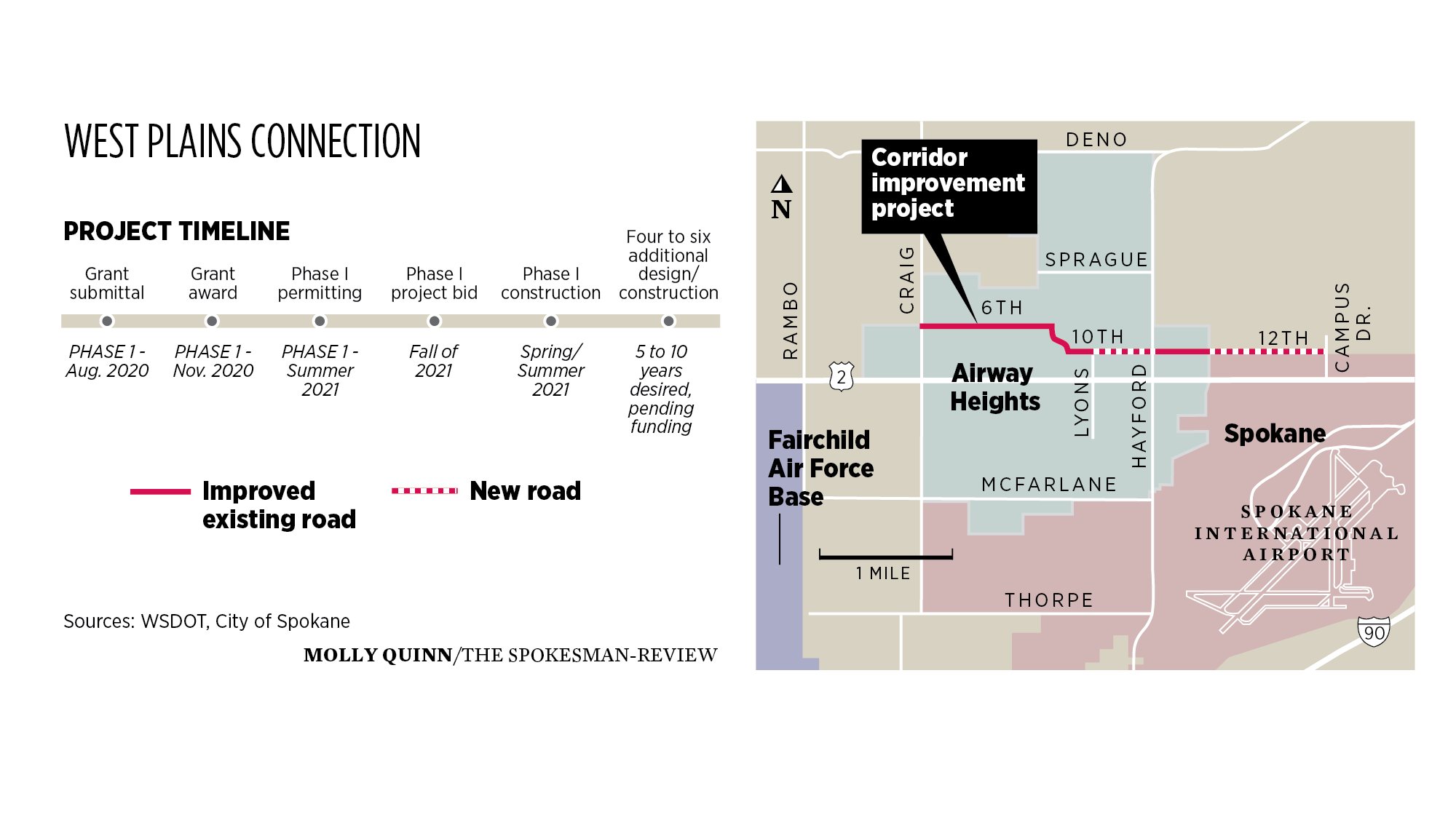
With a wider Highway 2 off the table, White, Anderson and a slew of other planners from various public and private entities have arrived at another plan: a patchwork of new and improved roads and paths running just north, and mostly parallel, to the highway, starting near the city of Spokane’s western edge and passing through all of Airway Heights.
The proposed new route along 12th Avenue, 10th Avenue, Garfield Road and Sixth Avenue even has a fancy new name: the West Plains Connection.
While the project has been on the minds of planners for a decade or more, it is moving now into the realm of the real, with a timeline and a basic plan in place. That plan’s elements include:
- An extension of Sixth Avenue in Airway Heights from its current terminus at Whitetip Avenue to Craig Road.
- An extension of 10th Avenue to Hayford Road, where it converts to 12th Avenue.
- An extension of 12th Avenue from Deer Heights Road to Campus Drive in the city of Spokane.
- Intermittent widening of Sixth and 12th avenues.
- The addition of stoplights, roundabouts or stop signs at various intersections.
- The addition of bike lanes and/or shared-use paths, as well as new Spokane Transit Authority bus stops.
But as this list suggests, there are aspects of the project that haven’t been decided. And planners are looking to residents to help them decide a number of design elements, such as whether to install unprotected bike lanes or separated shared-use paths, and whether to have center turn lanes or landscaped medians on certain stretches. A survey is available on the project website, westplainsconnection.com, for those interested in offering their input.
The aim is to have preliminary designs decided by next month, so officials can start the long process of obtaining the estimated $17 million the project will cost. Those designs are expected to be complete next year, with work beginning as soon as 2022 and finished sometime in the next decade.
While Todd Coleman, executive director of S3R3 Solutions, said the project represents an effort to be “proactive,” those working to complete the West Plains Connection will be racing against the clock – and the traffic counters.
Coleman, whose group is a partnership of the city, county and airport of Spokane that aims to promote development in the area, said the “impact of more congestion along this route is obvious and people are definitely feeling it.”
That’s bad not only for people who already live and work in the area but also for those Coleman is working to bring to it, often from larger cities that suffer from traffic issues they’re looking to escape by migrating to a relatively less-congested Spokane.
So as Coleman and other planners work to push for more development without undermining the source of the area’s growth, they’re looking to the West Plains Connection – and projects like it – as a mechanism for keeping things moving.
One of the main needs in the West Plains, Coleman noted, is housing for the area’s growing workforce, in part because as more people are able to live in the area, fewer people will have to commute to it.
As the new route passes through a number of large, undeveloped parcels of land, planners hope the West Plains Connection will unlock their potential for both commercial development and “for workforce housing,” Coleman said.
They also see the project as the “starting point” for a broader reimagining of the area’s transit infrastructure, one that will look at a whole series of new north-south and east-west corridors, Coleman said.
The next step in that process is likely to involve a remaking of 21st Avenue.
“But that’s more of a longer-term project,” Anderson, of Airway Heights, said. “We don’t see that as being ready to focus on just yet.”
Work is underway already, however, on another series of major West Plains transit projects closer to Interstate 90, including a pair of expanded interchanges, a new STA transit center and a widened Geiger Boulevard.
Work to watch for
Work will start Monday updating curb ramps for Americans with Disabilities Act compliance at Fourth Avenue and Howard Street, Fourth Avenue and Washington Street, and Hartson Avenue and Cowley Street.