Getting There: Dedicated bus rapid transit lanes on Division? Planners push to make it happen, fast
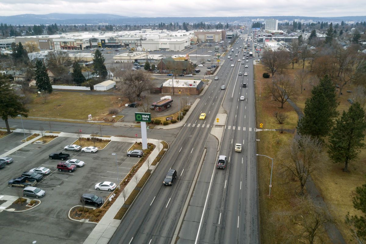
Imagine two of North Division Street’s six lanes of traffic are closed to cars and primarily dedicated instead to electric rapid-transit buses. They drop off and pick up passengers every 7½minutes at new stations that pop up at half-mile intervals along the side or in the center of the street.
That public-transit-focused vision for the car-centric corridor may sound far-fetched, but it could well become a reality – and relatively soon, local transit officials say.
A committee representing various jurisdictions and agencies recently selected four design options for what would be the city’s second bus rapid transit line, after the in-progress City Line.
They are currently soliciting feedback about the alternatives before they choose one, seek between $100 and $150 million to fund it and then build it.
Construction could begin as soon as 2025, and the line could open as soon as 2027, according to a Spokane Transit Authority fact sheet about the project.
That the North Spokane Corridor is supposed to be finally completed on a similar timeline, with an estimated completion date of 2029, isn’t a coincidence.
When the half-finished freeway is open for its entire 10-mile course, transit officials expect traffic on Division will decrease, allowing them to create the opportunity for dedicated bus lanes and, in part, bike lanes without having to widen the street.
If those ambitions are realized, they argue it won’t just be how people get up and down Division that radically shifts, but also what land use on the street looks like, creating opportunities for a denser, more walkable corridor.
How to make this all come together in this tight timeline is the subject of what’s known as Division Connects, a $1 million study that aims to come up with a plan for remaking the street.
Since beginning last year, officials from the Spokane Transit Authority, the Spokane Regional Transportation Council, Spokane County, the city of Spokane and the Washington State Department of Transportation have examined the corridor’s existing conditions, solicited public feedback via the project website and winnowed their options down to four plans.
There’s a center-running alternative with stations and dedicated bus lanes – or “business access and transit lanes,” as they’re official known – in the center of Division, plus three side-running alternatives that would place the BAT lanes and stations adjacent to the sidewalk. (To be clear, cars would be able to use the BAT lanes to make turns and enter businesses.)
The plans each contain different solutions to the complications presented by the one-way couplet section of Division and Ruby streets.
In all four options, the couplet includes protected bike lines, though they disappear after the streets come back together around Euclid Avenue. In one option, the couplet sections of both streets become two-way. In another, Ruby would be home to a two-way, protected cycle track.
Another conundrum involves deciding which way to go with the bus rapid transit line at the Y, where Division continues north and Highway 2 breaks off to the northeast toward Newport.
At a meeting last week of STA’s Planning and Development Committee, STA Director of Planning and Development Karl Otterstrom suggested he and his colleagues may defer the decision about what to do at the fork in the road by implementing a phased approach that allows flexibility for some period of time about where stations are installed north of Country Homes Boulevard.
The northernmost path of the corridor’s planned bus rapid transit line could depend, in part, he suggested, on the flurry of planned development in the area, including Greenstone’s recently unveiled proposal for a 1,450-unit development along Highway 2.
Otterstrom said officials have done some modeling to evaluate the four options based on seven main criteria: transit performance and user benefit, corridor mobility, equitable and inclusive transit, responsiveness to community goals, implementation feasibility, capital and operating costs and funding competitiveness.
But he and his fellow planners are also eager for public input. To that end, they have sent more than 4,000 postcards to nearby property owners and started reaching out to elected officials, neighborhood councils and major stakeholders on the street, such as NorthTown Mall, developer Harlan Douglass and commercial real estate firm NAI Black.
When reached Friday, NAI Black CEO Dave Black said he hadn’t yet spoken to anyone about the project or had an opportunity to consider it on his own.
But he did question a fundamental premise of the Division Connects enterprise: that the opening of the North Spokane Corridor will reduce traffic so much on Division that the street will have two lanes to spare for public transit.
He said he believes most people “drive up and down Division because they’re going somewhere on Division.” So while the NSC will attract through traffic, Black doubted whether it would be sufficient to make room for what’s being proposed.
“I think Division’s finally going to be fixed when the north-south freeway is finished, meaning it’s a viable street to travel on,” said Black, whose company leases, brokers and owns property all along the corridor. “And now they’re talking about minimizing it? Not sure it’s a good plan. But again, I haven’t read the plan or studied it.”
Jessica Engelman, chair of the grassroots active transportation-advocacy group SpokAT, has examined the Division Connects study so far and views it from a different lens, as an opportunity to not just add important new transit options to the street but to embark on a “holistic corridor project.”
While she’s a fan of bike lanes and public transit, Engelman said the “only successful way for (the Division corridor) to become a successful place in this city is to address land use.”
And how people use land, she says, is bound up with how they move around it.
Bus rapid transit and protected bike lanes work best when they travel through dense, mixed-use, pedestrian-friendly neighborhoods.
While project planners are “moving that direction in the couplet section,” she said, the mainline of Division would remain “unpleasant” for people walking, biking or waiting for the bus on a street without bike lanes and dominated by “strip malls with surface parking.”
Still, she called the study’s approach to rethinking the street’s transit and land use “heartening” and expressed optimism about its feasibility.
“This is actually a fairly easy project and they could even implement a version of it sooner, especially in relation to the bus rapid transit element,” she said.
After all, she said, creating BAT lanes “mostly just involves paint on the street.” The bus rapid transit component will be especially achievable, she noted, if planners opt for one of the side-running options, as Engelman would prefer.
Details about the alternatives and the study, as well as opportunity to provide input about the plan, are available at divisionconnects.org, through a link labelled Online Open House.
In addition, project organizers will host a virtual meeting Thursday at 7 p.m. A link to attend will be posted on the project site beforehand.
Whether you can make the meeting, you’d be wise to chime in while you can, because officials signaled at last week’s meeting that they aim to keep progressing as fast as they can, in part to try to take advantage of big transportation-infrastructure packages expected to emerge soon in both Olympia and Washington, D.C.
“We’re going to start moving very quickly on this,” Otterstrom said.
Work to watch for
The south curb lane of Second Avenue between Stevens and Bernard streets will be closed through Friday for Avista work.
The following streets will have lane closures through Feb. 19 for Quanta telecommunications work: Lincoln Street between Second and Third avenues; Third Avenue between Lincoln and Monroe streets; Second Avenue between Wall and Stevens streets; and Stevens Street between First and Second avenues.
The westbound curb lane of 29th Avenue between Rebecca and Myrtle streets will be closed, and traffic will be flagged through March 1 for Avista work.