Saturday rain was welcome, but did it put a dent in the drought?
Saturday was Spokane’s wettest day since January, but even though the water was welcome it won’t do much to alleviate Eastern Washington’s dire drought.
The weather station at the Spokane International Airport recorded 0.42 inches of rain Saturday. That’s the most precipitation Spokane has received in a day since Jan. 12, when the airport weather station recorded 0.86 inches.
National Weather Service meteorologist Miranda Cote said that the 0.42 inches of rain doesn’t come close to making up for the big precipitation deficit the region’s facing this year.
The National Weather Service talks about annual precipitation in terms of water years, which run from Oct. 1 to Sept. 30.
During the 2020-21 water year, Spokane has received 11.39 inches of precipitation, a 30% decrease compared to the 16.18 inches seen in a normal water year.
In terms of water years, 2020-21 is the 13th driest in Spokane’s history, Cote said. The driest water year on record was 1928-29, when the area received only 8.8 inches of precipitation.
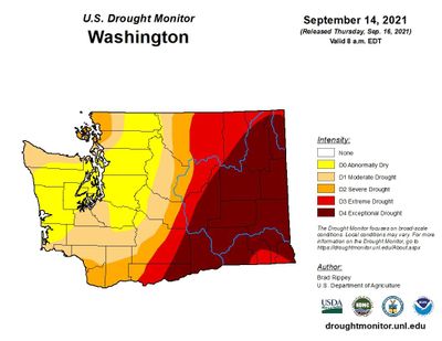
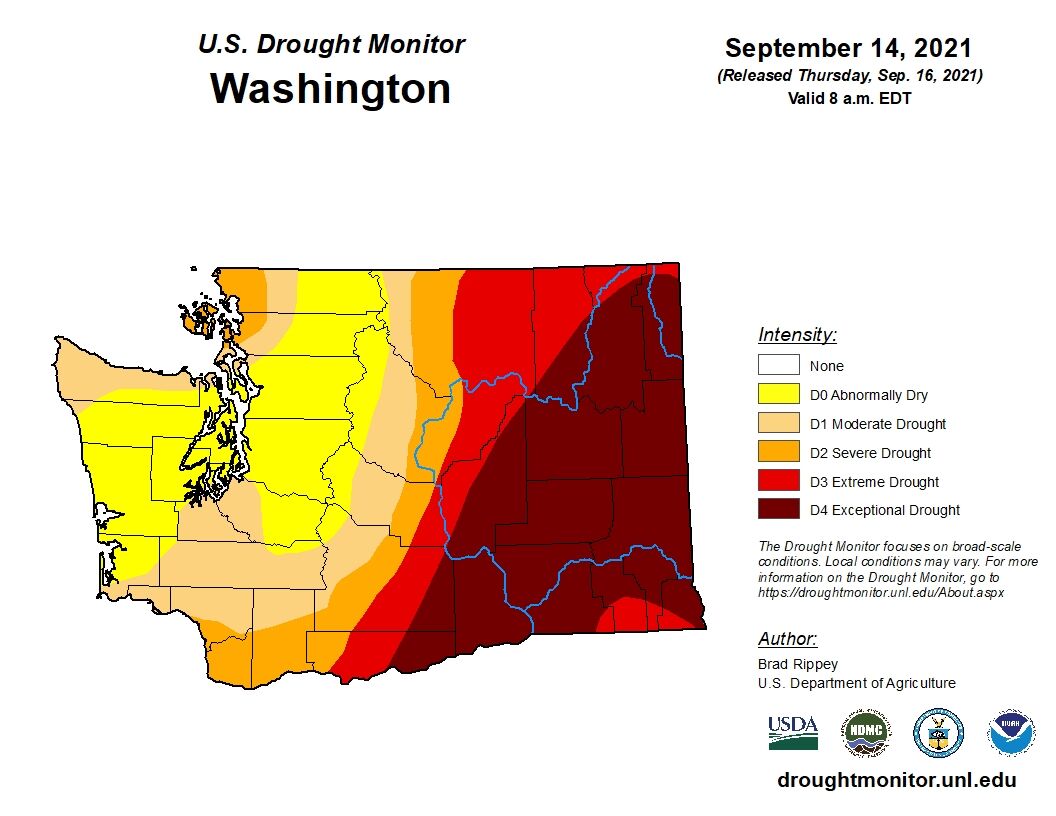
Eastern Washington and much of the West remain in “exceptional” drought, the most severe category on the U.S. Drought Monitor’s six-tiered system. Most of Eastern Washington, and huge swathes of the West, are marked by an alarming, deep red color on the Drought Monitor’s map.
All of Spokane County is in exceptional drought. Most of the surrounding counties are too, although the northern, higher elevation areas of Ferry, Stevens and Pend Oreille counties are in the somewhat less severe “extreme” drought category.
Everywhere in Washington is dry, but the northern portion of the Cascades Range is faring best.
Those mountains are “abnormally dry,” per the Drought Monitor, but technically not experiencing drought. Most of the West Side is either abnormally dry or in moderate drought.
The western half of North Idaho’s Panhandle is in exceptional drought while the eastern side is in extreme drought.
There are some positive signs on the horizon.
According to the National Weather Service’s Climate Prediction Center, the Pacific Northwest has a 40-50% chance of receiving above-normal precipitation in October. The prediction does not state how far above normal the precipitation may be.
The Climate Prediction Center’s model also shows a 40-50% chance of above-normal precipitation for Washington and North Idaho in November and December, although climate models become less accurate as they predict conditions further into the future.