Julia strikes Nicaragua as hurricane with ‘life-threatening’ flooding

Tropical Storm Julia is drifting westward through Nicaragua, bringing what the National Hurricane Center warns could be “life-threatening flash floods and mudslides” in Central America and southern Mexico. Up to 15 inches of rain are possible in the higher terrain of Nicaragua and El Salvador as Julia’s circulation continues to disintegrate inland and unload moisture.
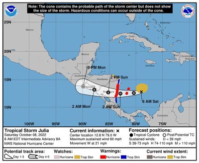
Julia made landfall as a Category 1 hurricane around Laguna de Perlas, Nicaragua, at 3:15 a.m. Eastern time. local time Sunday according to the National Hurricane Center. Maximum winds were around 85 mph. As of 11 a.m., Julia - centered 65 miles east-northeast of Managua, Nicaragua - had weakened to a tropical storm with 70 mph winds as it moved west at 15 mph.
Watches and warnings were discontinued for the Caribbean coast of Nicaragua, but tropical storm warnings were in effect for the coast of El Salvador and the Pacific coast of Nicaragua and Honduras on Sunday.
The Associated Press reported several thousand people in Nicaragua were evacuated from low-lying coastal areas ahead of the storm and that local news media showed images of trees down across roads.
Before crashing ashore in Central America, Julia swept across the Colombian islands of Providencia and San Andres - just to Nicaragua’s east. Authorities on Sunday morning said the winds and rain left minimal damage on the islands, where residents had braced for another powerful storm less than two years after Hurricane Iota ravaged the archipelago.
In a tweet Sunday morning, Colombian President Gustavo Petro said the passage of the hurricane through San Andrés left “minor damage,” including two people injured, two homes destroyed, and 101 homes damaged.
“Its passage through Providencia was milder,” Petro said. “As soon as air operations are restored, aid will arrive.”
Colombia’s national disaster risk management unit reported that five homes on the island of San Andrés had lost roofs and four sectors of the island experienced flooding.
Everth Hawkins, governor of the archipelago of San Andrés and Providencia, said in an interview on W Radio on Sunday morning that authorities were able to begin evaluating the condition of the island around 2 a.m. and found several fallen trees on homes and roof tiles ripped off houses. About four or five homes in Providencia were damaged, Hawkins said.
While authorities continued to assess the impact of the storm, Hawkins said the damage was not “catastrophic,” and paled in comparison to the destruction of Iota nearly two years ago, especially on the hard-hit island of Providencia.
The Archipelago of San Andrés, Providencia and Santa Catalina has a combined population of about 50,000 people, according to the most recent census figures.
Julia is the 10th named storm of the 2022 Atlantic hurricane season. The season to date has defied forecasts of an active season, with activity thus far only about 81 percent of average. That’s based on a metric of ACE, or Accumulated Cyclone Energy, a figure which takes into account the intensity and duration of a storm. It’s a rough estimate for how much energy storms expend on their strong winds.
Fifty-four percent of this season’s ACE was churned out by Fiona, which struck Puerto Rico, sideswiped Bermuda and slammed the Canadian Maritimes, and Ian, which ravaged Cuba and southwest Florida.
At 11 a.m., Julia was a tropical storm as its center of low pressure continued to fill in. Picture a low pressure center as the dip that results when you stir your coffee; the depression in the fluid grows deeper as you spin faster. But it you stop spinning, that depression will relax, and the fluid will return to a state of equilibrium - meaning there’s no difference in the height of the surface. The same premise is happening here.
Now that Julia is inland, warm waters from below can’t heat and remove air from the center. That allows the storm to weaken. On infrared satellite, one could spot a decrease in the intensity of colors near the storm’s center, signifying warming cloud tops. That means clouds aren’t as tall, and therefore that the storm is weaker.
While weakening, the storm is unloading a tremendous amount of moisture in the form of heavy rain.
Julia will drop widespread totals of 5 to 10 inches in Nicaragua and El Salvador with localized amounts to 15 inches. A lesser 3 to 6 inches with a few 10-inch totals can be expected in Honduras, Belize, northern Guatemala, and the Isthmus of Tehuantepec in Mexico. Parts of southern Guatemala and Costa Rica could see up to a foot.
“This rainfall may cause life-threatening flash floods and mudslides across Central America today and Monday,” wrote the National Hurricane Center.
Julia will emerge over the Pacific on Sunday afternoon or evening and begin to curve to the northwest, paralleling the coastline and prolonging its life while it slowly weakens into a remnant tropical depression.