Longs Pass avalanche: What happened in accident that killed 2

Four friends on a backcountry skiing trip last month set out to Longs Pass in the Okanogan-Wenatchee National Forest, well-prepared for the journey with decades of backcountry skiing experience and the appropriate safety gear.
But the mountains can be unpredictable.
On Jan. 9, an avalanche was triggered at Longs Pass during a skier’s descent, carrying and catching the entire group. Paul Markoff, 38, of North Bend, and Erik Henne, 43, of Snoqualmie Pass, died in the accident. Ian Laing, 47, who lives in Alaska, and Patrick Leslie, 47, who lives in Washington, survived.
In the month since the event, Laing and Leslie have collaborated with the Northwest Avalanche Center to produce an in-depth report on the incident, published Tuesday, to help other backcountry recreationists learn from the event.
The following explanation of events was put together using NWAC’s report, public records from the Kittitas County Sheriff’s Office and written comments Laing and Leslie provided on both to ensure accuracy.
Laing and Leslie declined to be interviewed by the Seattle Times, citing respect for the families of the deceased.
“This is an unbearable tragedy for the victims and their family, and we’re solely focused on supporting them right now,” the two wrote in a statement provided to the Times.
“We want to thank all the people involved in the search and rescue operation for their dedication and tireless effort. We currently hope for privacy and compassion for the victims’ families at this time – this event is still very fresh and painful for everyone involved.”
The group met at 29 Pines Campground on the morning of Jan. 8. With cell service still available, they checked the most recent avalanche forecast, issued the night before, for the area on NWAC’s website and conducted a group avalanche transceiver check.
Transceivers, also known as avalanche beacons, are a critical piece of safety gear for backcountry skiers. The devices are worn close to the body and emit continuous radio signals that can be detected by other transceivers in the area, allowing people to find one another.
During the check, Leslie’s transceiver reported an error indicating a nearby metal object. When he moved away from the cars they arrived in, it cleared.
From there, they made their way up to Fortune Peak Huts, their remote lodging site in the Okanogan-Wenatchee National Forest. The group got on snowmobiles to ride to the huts and skied some low angle slopes that afternoon.
There was no cellphone coverage or Wi-Fi at the huts on Thursday evening, meaning the group couldn’t get the Friday forecast for the area. The daily forecast for areas covered by NWAC is posted at 6 p.m. the evening before.
Each forecast includes a breakdown of the next day’s risk, including a forecast discussion, possible avalanche problems, a weather summary and other additional details. Avalanche danger is rated on a scale of one to five, with danger increasing exponentially between levels. The forecast will also include projected avalanche danger for the next day.
“We won’t give a lot of details for day two, but we’ll at least give the general danger rating for that day,” said Dallas Glass, the deputy director of NWAC. He explained that having the most up-to-date forecast is important as information can change between the first projection and the full-day forecast.
The group checked Thursday’s forecast for the East Central zone, where Longs Pass is located. That forecast listed Friday’s danger at level two (moderate) for the lower and middle elevations, and level three (considerable) for upper elevations.
The full Friday forecast issued Thursday evening changed, with the middle elevation’s (5,000-6,000 feet) danger increasing to level three.
In addition to forecasts, backcountry skiers have other techniques to assess the conditions and risks in an area. Glass explained that some of those are intuitive, like visual observations of the snow. Others are more technical, like a snow profile, which is performed by digging a hole in the snow to examine the layers.
On Friday morning, the group left Fortune Peak Huts and traveled to Longs Pass to backcountry ski for the day. They rode two snowmobiles to the Esmeralda Basin Trailhead, and from there set out on their skis and hiked to the Longs Pass Basin. It was a sunny day with minimal winds.
There, the group dug a snow pit and completed a snow profile at approximately 5,600 feet. Nothing of concern was noted.
The group skied their first two runs of the day on west-facing aspects between 5,300 and 6,300 feet, hiking back up between runs. At approximately 3 p.m., the group readied for a third run of the day and opted to ski down a south-facing slope at similar elevations.
At 3:40 p.m., they began their descent. Leslie went first, followed by Henne, Markoff and Laing. The skiers went one at a time, stopping at a minor low-angle rib separating two prominent gullies. Markoff had almost reached where Leslie and Henne were waiting when Laing began his descent.
A hard slab avalanche occurred immediately after, fracturing above Laing at the base of the rock. It caught and carried all four individuals, flowing into two separate gullies that split the group in half.
Leslie and Laing were carried to one side and partially buried but were able to extricate themselves. Henne and Markoff were carried 300 feet to the other side. Markoff was fully buried and not visible, while Henne was almost completely buried with one ski visible.
Immediately after freeing themselves, both Leslie and Laing began searching for Henne and Markoff. Leslie sustained a knee injury, later identified as a torn ACL, which made it difficult to move downhill.
Laing located and identified Henne’s ski in the snow and began digging. It took more than 40 minutes for Laing to dig out Henne so he could attempt to perform CPR. It was unsuccessful. At the same time, Leslie searched for Markoff using his transceiver.
During the search, Leslie said that his transceiver received periodic error codes. After the CPR attempt, Laing joined Leslie and also reported issues obtaining a signal with his transceiver. Leslie said they searched for Markoff for two hours without success.
Leslie was skiing with a Garmin InReach device, a small satellite communicator separate from transceivers, that allowed him to send an SOS message outside of cellular network with GPS coordinates and details while still in the avalanche field.
According to the Kittitas County Sheriff’s report, the Washington State Emergency Operations Center reported an emergency Garmin InReach activation from Leslie at 4:40 p.m. Leslie said the log on his phone showed the first activation was sent at 4:01 p.m.
Leslie sent two messages. The first relayed there had been an avalanche and one person was missing. A second message identified the missing individual as Markoff and said there were likely two fatalities.
The Garmin InReach messages allowed Kittitas County Search and Rescue, members from NWAC and the sheriff’s department to begin coordinating their response.
With concern for their survival, Laing and Leslie left the scene to return to Fortune Peak Huts. The NWAC report said they departed at 5 p.m.; Leslie said it wasn’t until 6 p.m.
When Leslie and Laing arrived back at Fortune Peak Huts around 7:15 p.m., a team with a deputy and search and rescue volunteers met them.
A second response team gathered at the 29 Pines Campground, where another deputy assessed the situation as too dangerous to attempt a nighttime search and rescue operation. The team began coordinating an operation for first light, which included NWAC forecasters, avalanche K9s, and a snowmobile and winter ground team.
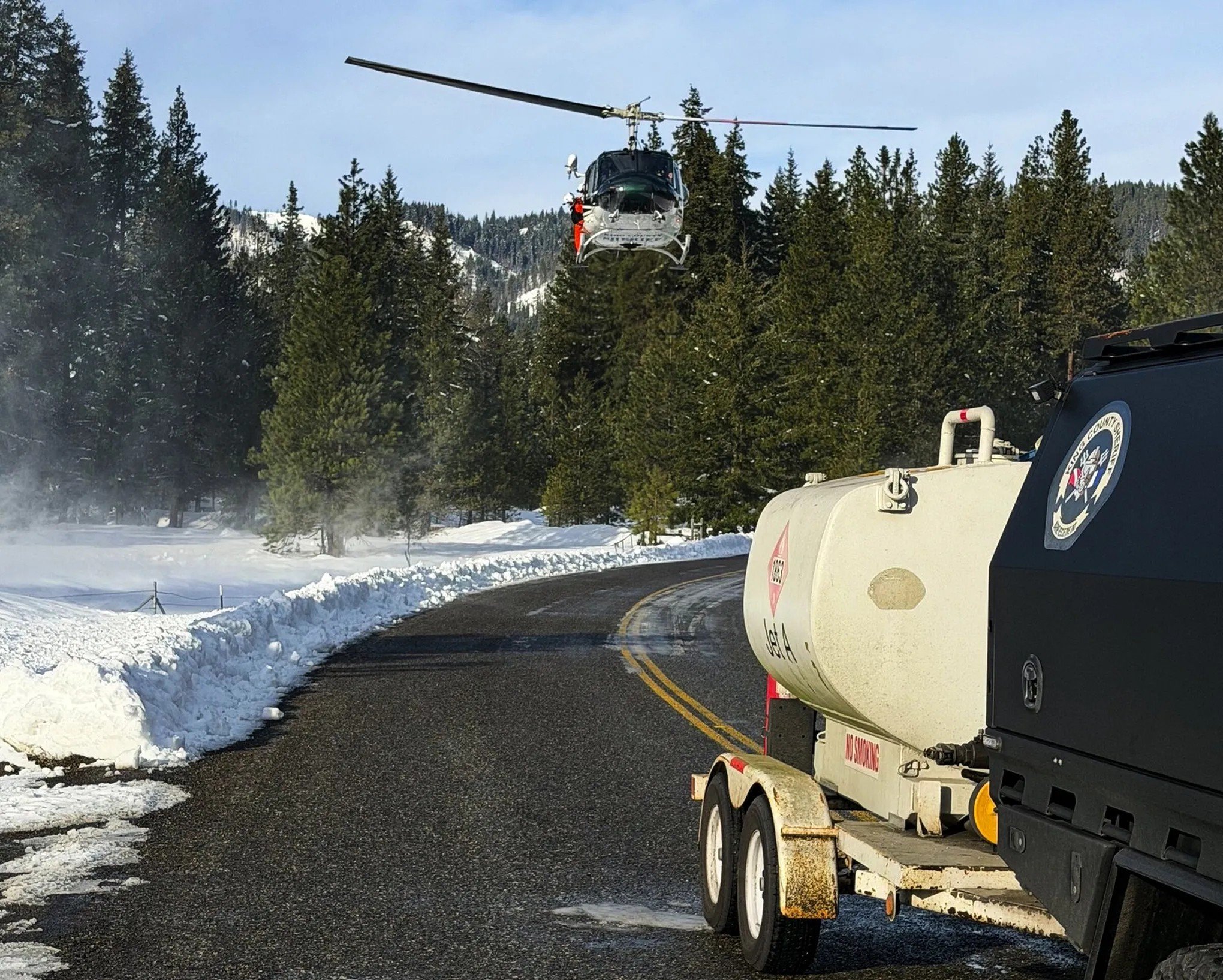
Laing and Leslie were brought down safely around 10 p.m. On Saturday morning, Markoff and Henne were successfully recovered and transported off the accident site by King County Search and Rescue Helicopter technicians.
NWAC always produces a short report on avalanches that occur within their covered regions. In some cases, they will produce a longer “case study” report, as was the case with Longs Pass. Glass described case studies as an opportunity to learn from the decisions made and conditions on the ground.
“Ultimately, we can hopefully take those learning outcomes and put them into our own travel in the backcountry so we can all be safer,” Glass said.
Laing and Leslie opted to collaborate with NWAC in hopes of helping other backcountry recreationists learn from the event. The report’s findings emphasize the importance of having access to real-time data or opting for simpler terrain; checking and updating transceivers; and conducting the right kind of snowpack observations.
They also suggested utilizing travel techniques that only expose one team member to a hazard at a time – although opting for this strategy can have drawbacks depending on other variables in a given situation.
The NWAC report highlighted that the group carried the correct equipment and had the right skills to respond after the avalanche. It also stressed that while it may not have prevented fatalities, the satellite communication device allowed crucial contact with emergency services.
“These facts may not have changed the outcome of this incident. However, being prepared for emergencies can have real impacts,” the report said. “These skills and tools should be considered by anyone traveling in remote backcountry settings.”