Wind River Range is high note for Spokane Mountaineers
On July 29, two Spokane Mountaineers departed after work to drive 670 miles overnight to Pinedale, Wyoming, where they left their car, and boarded a shuttle vehicle for more than two hours to a trailhead near Lander.
After a brief rest, they set out on a 16-mile acclamation hike from elevation 8,800 feet to nearly 11,000 before racing a thunderstorm back to camp.
That was just the warm-up.
The hard part started when Shuwen Wang and Tyler Nyman donned packs with food for nine days and set out on an unsupported and largely above-timberline traverse of the Wind River Range.
Nyman had planned the trip after months of poring over maps, guidebooks and Google Earth before settling on an 8- to 10-day, south-to-north traverse from Worthen Meadows to the Green River Lakes.
Others had expressed interest, but in the end, after normal hikers pondered what the trip involved, just the two of them committed to the wilderness.
After hiking about 100 miles, the loop would be completed by hitchhiking back to Pinedale.
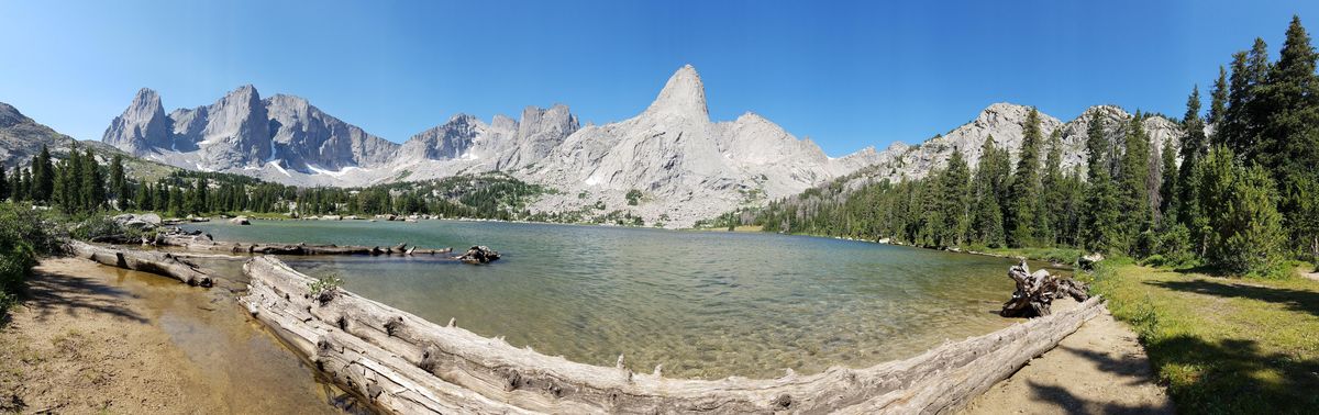
The Wind River Range, which extends for 100 miles in western Wyoming south of Jackson and the Grand Tetons, attracts scores of hikers, climbers and equestrians even in the midsummer bug season that can rival Alaska.
The range is only about 25 miles wide, but the mountainous alpine core of The Winds requires a hike of about 8 miles from any direction. Backpackers in the interior are beyond most dayhikers. Solitude can be found.
The crest of The Winds runs along the Continental Divide where adventurers will find more than 40 named peaks higher than 13,000 feet, including 13,804-foot Gannett Peak, the highest point in Wyoming.
Neither Wang nor Nyman toted a fishing rod, and it’s probably a good thing for a group with a strict itinerary. The Winds are sprinkled with more than 1,300 named lakes – many holding trout – and perhaps another thousand unnamed waters.
“You don’t have to carry much water,” Wang said. “It’s everywhere.”
The 2.25-million-acre range forms a triple divide for three major western watersheds: the Columbia River, the Colorado River and the Missouri. The combination of jagged granite, seven glaciers, alpine forest and open meadows is headwaters for the Green River.
The Winds are the most popular section of the 426,484-acre Bridger Wilderness, which is bordered by the Fitzpatrick Wilderness to the northeast and the Popo Agie Wilderness and Wind River Indian Reservation to the southeast.
Although some 600 miles of trails lace The Winds, Nyman, a volunteer firefighter who works at Haakon Industries in Cheney, had planned a traverse that often headed cross-country through gnarly passes.
About 25 percent of their 100-mile trek was off-trail. Ellingwood Pass, between Elephant Head and Harrower Peaks, involved hopping over talus for 5 miles.
They’d purchased new ultralight packs and gear this year, all field-tested on several previous treks to get their system down and their bodies hardened.
They dried their food at home, planned it carefully and packaged it as minimally as possible.
But even with 35-pound packs at the outset, scrambling up over granite talus at average altitudes of 10,000 feet or more took its toll.
“It was the hardest hike I’ve ever done,” said Wang, a pharmacy professor at Washington State University-Spokane. “I finished some days happy, but totally exhausted.”
The attractions kept them both going.
On the first day in, they met 20 Boy Scouts from Texas but climbed away from the group after a 14-mile hike that left them feeling the altitude.
“We were glad we made it to a camping spot (near Sanford Park) early, about 3:30, because hikers started coming by looking for a spot to pitch their tents,” Nyman said.
The next day, they hiked trail, rock and tundra to the Cirque of the Towers, one of the most popular areas in The Winds. The 270-degree ring of peaks and vertical-walled ridges contains several glaciers and encloses a large lake in a rocky basin, headwaters of the North Popo Agie River.
“The scenery was stunning,” Wang said.
In the middle of the cirque, on the north side of Lonesome Lake, they found a track going uphill toward 11,400-foot Texas Pass.
They traipsed through fields of wildflowers, climbed along a cascading brook below Pingora, a prominent steep-walled spire in the Cirque.
Near the pass, they kicked steps into snow and donned jackets from their packs as they forged into a suddenly bitter wind and down a steep scree slope.
“That was a taste of what was to come,” Wang said.
But all was well in their camp at Shadow Lake, where the backside of the Cirque of the Towers made an impressive backdrop.
“After that, we started to lose track of the number of lakes and peaks we passed,” Wang said.
Nyman described the Desolation Valley they entered the next day as being “surrounded by a range of skyscraping peaks” with “a string of alpine lakes.”
They reveled in the remoteness of the core, “and we passed few people when we were on Continental Divide Trail,” he said.
Food was a big part of each day for keeping energy high and boosting their mood.
“We substituted chocolate-covered coffee beans for real coffee to save stove fuel and increase calories,” Wang said, indicating that decision might be reviewed before the next trip. “We figured 15 coffee beans equaled one cup of coffee.”
One tough stretch of the trek was negotiating the pass and seemingly endless expanse of talus between Raid and Bonneville peaks. The scramble was followed by mixed terrain and Class 4 downclimbing that was time-consuming and dangerous.
“Toward the bottom we encountered thickets of willow and krummholz that proved challenging to maneuver around,” Nyman said, noting they were glad to finally make camp at Lower Bonneville Lake, where water in puddles froze that night.
Heading up to Sheila Lake the next day, they continued up another difficult 11,450 foot pass between Nylon and Sentry Peaks.
“We gazed in disbelief,” Nyman said, “and then the climb up the pass was longer and steeper than it looked. The talus was big and loose, so we decided to take our time and be safe.”
Still, one boulder shifted under Nyman’s weight and slid down the slope.
“Shuwen was very careful not to follow too close behind me,” he said, admitting that the incident rattled him.
“On a few of the routes we chose, we got halfway through and I’d say, ‘This was a bad decision,’ and then we’d continue,” Wang said.
After working through some navigation challenges, they camped at Halls Lake.
“The lake was crystal clear and rimmed on one side by a barren rocky ridge,” Nyman said. “We had not seen another person the entire day.”
The next day presented more navigation issues.
“We were lost for about half of the day,” Nyman said.
Even though they were using trails, they were not well-marked. What they thought was a main trail faded away as they entered more trees that blocked views of landmarks.
A good session of old-fashioned map reading and exploring finally put them onto the Fremont Trail, over Hat Pass and to a campsite at Timico Lake.
Certain lakes among the hundreds they passed stood out. Some lakes had waterfalls or were filled by inlets over natural waterslides.
“Upper Cook Lake seemed incredible to us the way the water was cradled by the mountains,” Nyman said as he described the next day of hiking. “The water from the lake tasted so good, we renamed it ‘Delicious Lake.’ ”
As they hiked into view of ragged peaks in the north end of the range, they waltzed along sidewalks of granite slabs at Wall Lake. Life was good.
Day 7 should have been equally spectacular as they headed into the scenic Titcomb Basin, but Wang remembers it as “the day from hell” as they struggled through a relentless barrage of storms.
“I felt like we were going to die,” she said.
“There was really no safe place to go,” Nyman said. “The thunder was deafening. The hail was hitting us like bullets.”
They fought off hypothermia and worried about lightning as they hiked, hunkered, hiked over treacherous hail-coated rock, hunkered in a cave again, and hiked.
As winds slammed their tent that night, they decided to abandoned their layover day at Indian Basin and the planned scramble to the top of Fremont Peak, the second tallest in The Winds.
They bailed out on Day 8, a day early, following the route along Island Lake, perhaps the most popular trail in the range.
“Pack strings of horses and llamas were often accompanied by ten or more people,” Nyman” said. “Hikers had gear spread out on rocks to dry.”
“Hitching back to Pinedale was easy, and we soon were headed back to Spokane,” Wang said. “After being in The Winds, the Grand Tetons weren’t all that impressive as we drove home.”