How will Spokane County carve up its commissioner districts in 2023? Here are some options
The independent committee charged with dividing Spokane County into five commissioner districts unveiled draft maps late Tuesday night, giving the public a first glimpse at what the county’s political boundaries could look like for the coming decades.
Each of the four maps presents a different option for splitting the county. One appears to clearly favor Republicans and would likely create a 4-1 GOP commissioner majority, another might give Democrats a chance of seating three commissioners and two maps fall somewhere in between.
“I thought everybody did a great job of giving the community some variety,” committee member Robin Ball said.
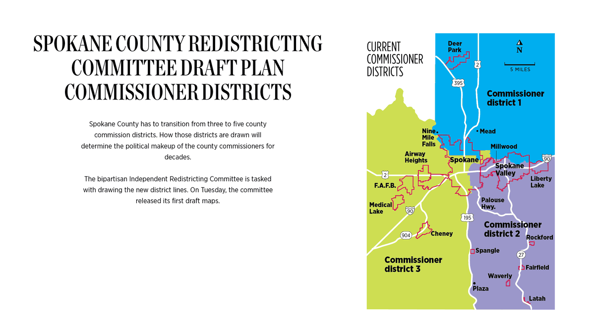
Spokane County currently has three commissioners – Republicans Josh Kerns, Al French and Mary Kuney. Those commissioners run in district-specific primary elections but are chosen by voters countywide in the general election.
That arrangement has to change due to a law enacted by the state Legislature in 2018. The county will transition to five commissioners with elections in 2022, and those commissioners will be chosen only by voters within their own districts.
Before the move to five commissioners can happen, the county has to shift to five districts. It’s the Independent Redistricting Committee’s job to redraw the district lines. The five-member committee includes two individuals appointed by local Democrat state legislators, two chosen by local Republican state legislators and a nonvoting chairperson.
How the committee draws the new lines will have major ramifications for the county’s future because the new districts will help determine the commissioners’ political makeup for decades.
State and federal law prohibits the redistricting committee from drawing lines that favor any political party. But creating new districts is an inherently political process, and based on the four draft maps, the four voting committee members have difficult negotiations ahead of them in the coming weeks.
Between now and the first week of October, the committee has to whittle the four maps down to one. After that, the committee has to agree on a final map by Oct. 23.
Committee members have stated their desire to agree on a map at the local level. If they can’t agree, the redistricting decision will go to a state-level committee. If the state-level committee can’t agree on a map, the decision will be left to the courts.
“We are so much better off solving this in Spokane County,” said Ball, a former chair of the county’s Republican Party.
The rules
Each of the four voting committee members drew one draft map. By state law, the districts within the maps have to meet certain criteria.
Districts cannot differ in population by more than 10%, and ideally the population gaps won’t exceed 5%. In Spokane County’s case, each district must have approximately 108,000 residents. All of the draft maps meet the population requirements.
Districts also have to be compact, meaning they can’t be serpentine or bizarrely shaped. The draft maps meet the compactness requirement.
As much as possible, committee members have to draw districts bordered by natural boundaries. And districts should maintain communities of interest.
There’s no concise definition for communities of interest, but they can include neighborhoods, school districts and areas with distinct cultural or racial identities.
By law, districts cannot be drawn to favor any racial group or political party.
Map A
Map A is perhaps the most straightforward and probably the one Democrats will fight hardest.
It lumps central Spokane into one district bordered by Wellesley Avenue to the north and 29th Avenue to the south.
The district’s eastern edge isn’t a straight line, but for most of its length it stops short of Spokane’s border with Spokane Valley. The district primarily uses the Spokane River as its western edge.
Map A splits the rest of the county into four rectangular quadrants.
U.S. Route 195 bisects southern Spokane County into two districts. The southeast district includes most of the southern half of Spokane Valley while the southwest one incorporates Airway Heights, Medical Lake and Cheney.
U.S. Route 2 splits the two northern districts. The northwest one is geographically smaller, but includes a significant amount of north Spokane. The northeast district includes about half of Spokane Valley, as well as Liberty Lake.
An analysis by The Spokesman-Review based on voting trends suggests Map A would likely yield four Republican county commissioners and one Democratic commissioner.
Brian McClatchey, one of the two Democrat-appointed members of the redistricting committee and the director of policy and government relations for the Spokane City Council, said Map A is unfair and a nonstarter. It gives a blatant advantage to Republicans and would “bake in a Republican majority for a long, long time,” he said.
“I don’t know any other way to see it,” he said. “Scenario A really tries to pack as many Democrats as they can into a single district in the core of the city.”
Map B
Democrats will probably like Map B. It appears to guarantee one Democratic commissioner seat and also includes two potential swing districts.
In order for Democrats to win multiple commissioner seats, the new commissioner districts will probably have to split Spokane into at least two hearty chunks. Map B does that.
Map B’s District 1 covers Spokane west of U.S. Route 2 and south of Interstate 90. It also includes Airway Heights.
Northwest Spokane, east of U.S. Route 2, falls in District 2, which goes south to 29th Avenue.
Map B’s District 3 is one of the most interesting districts in the four draft maps. It includes the South Hill while also incorporating Cheney, two areas of the county that lean heavily Democratic.
Under Map B, most of the county’s rural areas fall in two large districts. One covers the county’s northern end as well as a sizable portion of Spokane Valley. The other is enormous, covering all of southern Spokane County.
Map C
Like Map B, Map C would likely guarantee one Democrat commissioner and could include two swing districts.
It divides the city of Spokane into three large pieces.
One district covers northwest Spokane and uses the Spokane River as both a western and southern boundary. Nevada and Hamilton streets function as the eastern border.
Another district covers east Spokane and western Spokane Valley.
The South Hill falls in the same district as Airway Heights and Medical Lake.
The southern half of Spokane County, including east Spokane Valley, would be one district. The northern half of the county, including Liberty Lake, would be another.
Committee members Jim McDevitt, the former U.S. attorney under President George W. Bush and head of the Spokane Police Department, local attorney Natasha Hill and Ball were unwilling to say which maps they drew, but McClatchey didn’t mind saying he drew Map C.
McClatchey said he’s been tinkering with map ideas for months and spent about 50 hours in earnest drawing his draft map.
He said he started out by splitting Spokane along its City Council seat lines – wanting to keep those communities intact – and growing those districts outward.
The hardest decision, McClatchey said, was what to do with Spokane Valley. He chose to split the Valley along east-west lines. The other three maps essentially cut the Valley in half from north to south.
Map D
Map D is similar to Map A, but it doesn’t put central Spokane into one district. Instead, Map D cuts Spokane in two halves, one to the north and one to the south. Euclid Avenue serves as the main dividing line.
North Spokane County, including northern Spokane Valley, would make up one district. The county’s southeast quadrant, including southern Spokane Valley and Liberty Lake, would be another district. The southwest district would include parts of western Spokane, Airway Heights, Medical Lake and Cheney.
McClatchey said that at first glance, Map D gives Republicans an advantage, but it also has some decent characteristics that could make it workable.
Coming compromises?
McDevitt said that when he drew his map he focused on creating districts that give rural residents strong representation.
“You need to make sure that a city doesn’t rule the county, that’s one thing that I wanted to try to accomplish,” he said.
Ball said she had a similar philosophy in drawing her map, and added that rural residents in unincorporated areas need a strong voice.
“You look at the city of Spokane, they have a city council, they have a mayor,” she said. “They have representation at the city level.”
Hill, McDevitt and Ball didn’t voice any specific opposition to a specific map.
“None of them stood out to me as particularly problematic,” said Hill, one of the two Democrat-appointed committee members. “I still feel very confident that we’ll be able to reach consensus.”
McClatchey explained that he’s focused on making sure the commissioner districts accurately reflect the county’s political makeup.
In the 2016 presidential election, Democratic presidential candidate Hillary Clinton won about 41% of the Spokane County vote, McClatchey noted. President Joe Biden managed 46%. Democratic senators Patty Murray and Maria Cantwell typically earn just under 50% of the vote.
Based on those numbers, at least two of the five county commissioners need to be Democrats in order to accurately represent the county, McClatchey said. District lines that don’t give Democrats a chance to win two seats give an unfair advantage to Republicans and therefore don’t comply with the state statute, he said.
Both Ball and McDevitt said despite the differences between the draft maps, they’re confident the committee will be able to compromise and come to an agreement.
“I think we can get there,” Ball said. “I think we’ll come up with a way to make them fit.”
Committee chairwoman Elaine Couture could not be reached for comment.