Two or three, that is the question: Spokane County redistricting committee debating how to split city
There’s one fundamental question at the heart of an ongoing debate between the Republican and Democrat sides of the committee splitting Spokane County into five commissioner districts: Should the city of Spokane be divided into two pieces or three?
On Tuesday, the bipartisan redistricting committee’s members put their draft maps on easels, broke out the dry-erase markers and began debating specifics about how to compromise and settle on one, final map.
How to carve up Spokane and its more than 220,000 residents remains the biggest obstacle to consensus because how the committee splits Spokane’s votes will help determine the number of Republican and Democrat county commissioners. The commissioners are Spokane County’s most powerful elected officials and set policy for the county government.
It’s possible to draw a map that corrals the bluest part of Spokane into one tiny district, likely giving Republicans four county commissioners. The committee could split the city into two districts that might elect two Democrat commissioners. There are ways to slice Spokane in thirds in order to give Democrats a good chance at winning three seats. And there are practically infinite ways to create all sorts of swing-district scenarios.
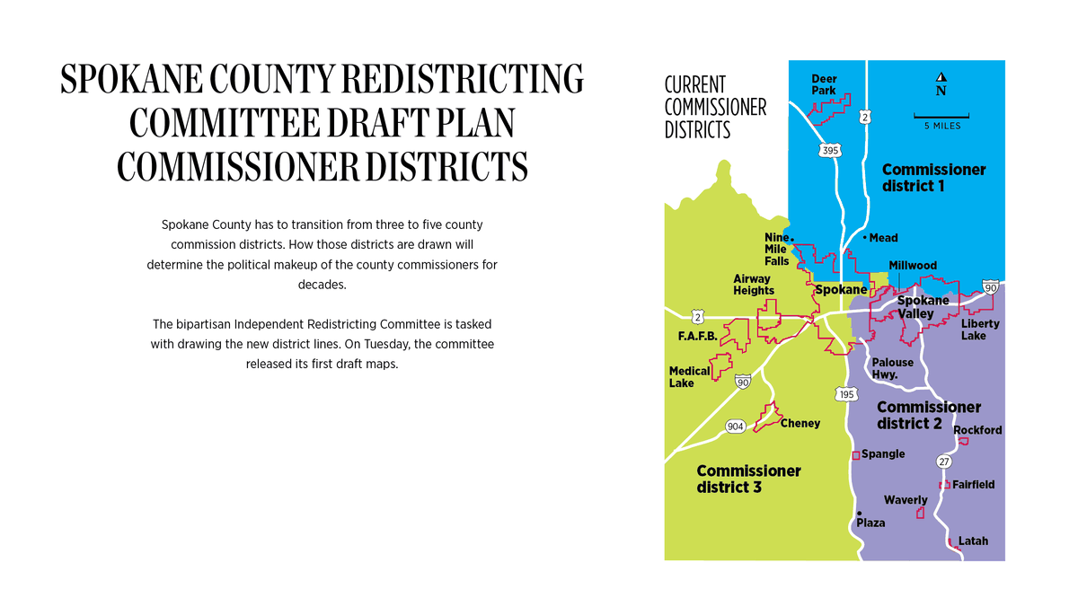
Spokane County currently has three commissioners, all Republicans. A new state law is forcing the county to move to five commissioners who will be elected in 2022. How voters pick those commissioners will change, too. Right now, commissioners run in district-specific primary elections and countywide general elections. In 2022, voters will only vote for one, district-specific commissioner in both the primary and the general.
The bipartisan redistricting committee includes two Democrat-appointed members, two Republican-appointed members and a nonvoting chairperson. In late August, the four voting committee members released four map proposals, each of which split the county into five districts of roughly 108,000 residents a piece.
Since late August, the committee has whittled the four proposed maps to two, one drawn by Republican-appointed committee member Jim McDevitt and one drawn by Democrat-appointed committee member Brian McClatchey. Now the committee members have to fuse those two proposals together into a mutually agreeable final map.
Despite the high stakes, conversations between committee members have remained friendly. Both sides say they’re willing to compromise in several areas – for instance, McClatchey said he has no issue with keeping the West Plains cities together even though the two Democrat-drawn draft maps break up those communities.
Even though the committee members still are laughing at each other’s jokes and have made some progress toward a final map, they haven’t made much headway on the critical Spokane-split question.
The clock is ticking. The committee has given itself an Oct. 12 deadline to create a draft of the one, final map. If the committee can’t agree on a finished map by Oct. 23, the decision will pass on to a state-level redistricting committee, which all four committee members have said they want to avoid.
The Spokane problem
Per state law, the redistricting committee can’t draw lines that favor or disfavor any political party or racial group.
Still, redistricting is almost always a political process. The committee members aren’t pretending to be apolitical, they’re ideally trying to agree on lines that both sides believe accurately represent county residents’ interests.
McDevitt said that because roughly 55% of Spokane County voters are Republicans and 45% are Democrats, it would be fair if the new commissioner districts result in a 3-2 Republican-Democrat county commissioner split.
McDevitt’s map would likely create that scenario. It includes two Spokane districts, one large, rural district to the north and two large, rural districts to the south divided by U.S. Route 195.
“It gives proportionate representation in the county (for the city),” McDevitt said of his map. “But it also gives the rest of the county, including the smaller cities, their own share.”
McDevitt said Spokane shouldn’t be able to choose a majority of the county commissioners. Spokane voters shouldn’t “rule the county,” he said.
McClatchey said he disagreed with both of McDevitt’s arguments.
Yes, Spokane County voters are 55% Republican and 45% Democrat, McClatchey agreed. But that doesn’t mean Republicans should be guaranteed three commissioner seats and Democrats should be guaranteed two.
“The way I translate that is, Republicans get not-quite three seats,” McClatchey said. “We should have two D seats, two R seats and a toss-up.”
McClatchey’s map might achieve that. It contains two huge, rural districts for the northern and southern halves of the county – those would likely go Republican – and splits Spokane into three chunks, at least two of which likely would elect Democrats.
One district lumps northeast Spokane with western Spokane Valley, one contains northwest Spokane and the third puts the South Hill with most of the West Plains cities, minus Cheney.
A map that doesn’t give Democrats at least a chance at winning three seats would give an unfair advantage to Republicans and therefore wouldn’t comply with state statute, McClatchey said.
McClatchey also said the argument that city voters should be confined to two districts is problematic. He noted that some of the public comments the committee has received echo McDevitt’s concern about Spokane controlling the commissioners.
“They’re not saying, ‘Don’t let the city of Spokane Valley control the county,’ ” McClatchey said. “They’re not saying, ‘Don’t let Airway Heights control the county.’ They’re saying, ‘Do not let that evil city of Spokane control the county.’ ”
He said it’s obvious why people are asking the committee to do that.
“Everybody knows Spokane is sort of deep-blue territory, the bluest place in Eastern Washington,” McClatchey said. “For us to tilt that so those voters are broken up into blocks that dilute their voice, I think we have to be really careful about that. It’s a disadvantage to those Democrats that live in Spokane.”
McClatchey added that having more competitive districts will increase interest in county commissioner elections and increase turnout, which is a positive.
Natasha Hill, the other Democrat-appointed committee member, said it’s important that the new commissioner districts don’t dilute the voices of people of color and the poor. She said she’s worried about how McDevitt’s map splits Spokane along north-south lines, giving one district to the wealthier south and one to the poorer and more diverse residents in the north. Hill’s map, and McClatchey’s, both divide north Spokane into two districts and put the South Hill into a third district.
People who have historically been disenfranchised shouldn’t be packed into one district, Hill said.
“I think it’s important to remember that this is about all the people, not just the people who vote,” Hill said. “Unfortunately in our country voting is a privilege. We have active campaigns in our country to dissuade people from voting.”
The committee members’ stances on the Spokane question didn’t budge much at the last meeting last Tuesday. The committee has asked FLO Analytics, the contractor helping the redistricting process, to provide some modified maps for discussion at the group’s meeting on Tuesday.