Redistricting debate begins: Compromises will help committee settle on one commissioner district map
The independent committee redrawing Spokane County’s commissioner districts began discussing map proposals for the first time Tuesday, marking the start of an eight-week compromise process that will determine the future political makeup of the county government’s most powerful elected officials.
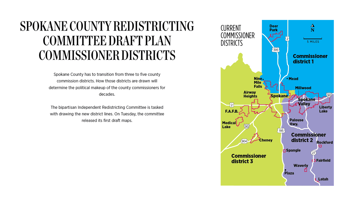
Back in 2018, the Washington Legislature passed a law that forces Spokane County to transition from three to five commissioners.
Currently, the county has three commissioners, each of whom runs in a district-wide primary election and a county-wide general election. For more than a decade, all three Spokane County commissioners have been Republicans.
That will likely change once the bipartisan redistricting committee redraws the county’s districts and voters elect five district-specific commissioners in fall 2022. At least one Democrat will likely earn a county commissioner seat, but how the redistricting committee splits the county will determine if Democrats have a chance at winning more than one.
On Tuesday, the four voting committee members – Republican and Democrat state legislators appointed two each – talked about the four draft redistricting maps that they released last week. Each committee member drew one map.
Despite the political ramifications of the redistricting process, and the significant differences between the four maps, Tuesday’s discussion wasn’t contentious. Each committee member raised concerns with certain map features, but they also expressed general agreement in some areas.
“(There’s) plenty of room to compromise,” said Brian McClatchey, one of the two Democrat-appointed committee members and the director of policy and government relations for Spokane City Council.
Map A out?
Both McClatchey and attorney Natasha Hill, the other Democrat-appointed committee member, said they had issues with Map A.
Map A is arguably the most straightforward of the four draft maps. It includes one geographically small district that encompasses central Spokane and four largely rural districts that include Spokane’s outer edges.
Based on recent election results, Map A would likely lead to one Democrat county commissioner and four Republican commissioners.
Republican-appointed committee member Robin Ball, former chairwoman of the Spokane County Republican Party, drew Map A. She said one of her main focuses when drawing her map was ensuring rural communities were well represented.
“I’m hearing more and more comment about not overloading the city with commissioners, because they have a mayor and city council, they have their government infrastructure in place,” Ball said. “So the areas that are underrepresented would be more likely to be rural and unincorporated areas.”
For now, the committee will essentially be setting Map A aside and focusing on maps B, C and D. The committee could still borrow ideas from Map A and incorporate them into the final map.
Committee members have asked FLO Analytics, the contractor helping the committee redraw the district lines, to analyze maps B, C and D. The analysis will give committee members more data and a better understanding of how each map conforms with fire districts, school districts and other communities of interest.
Ball said she had no issue with focusing on maps B, C and D.
“I think A would need way more tweaking,” she said.
The rural versus urban debate
Committee members did discuss specific map components they either liked or disliked, but much of Tuesday’s discussion centered around broader topics.
The committee members have differing views on how the county should be split along urban-rural lines.
Like Ball, Republican-appointed committee member Jim McDevitt, former U.S. attorney under President George W. Bush, said that when drawing his map, he wanted to make sure rural residents were well-represented.
“I wanted to be able to give the rural areas, which would include the smaller towns, an equal voice or maybe even a greater voice – let’s say equal to or greater – than downtown Spokane,” McDevitt said.
The city of Spokane shouldn’t have too much of a say over county government, McDevitt said.
“I didn’t want the city of Spokane to control the county commissioners,” he said. “But I did want the city of Spokane to have strong representation.”
McDevitt drew Map D, which has some similarities to Map A, but also important differences. It creates three large rural districts instead of four, and splits Spokane into two districts: northern and southern.
Map D could lead to three Republican county commissioners and two Democrats, or one Democrat and a swing district. Both Hill and McClatchey said they like certain elements of Map D.
McClatchey said he doesn’t fully agree with Ball and McDevitt’s arguments that special consideration should be given to rural voters when redrawing the district lines. The new districts should have a good urban-rural balance, he said.
He noted that roughly a third of Spokane County residents live in rural areas and more than 60% live in cities. Because of that, rural people shouldn’t necessarily be choosing 60% of the commissioner seats, he said.
“I don’t think there should be a worry about the city having too much power,” McClatchey said.
Community questions
Keeping communities of interest together is crucial, committee members say.
Communities of interest include neighborhoods, school districts, towns and areas with shared racial or cultural identities. If possible, the committee has to avoid splitting communities of interest.
McDevitt and Ball said they have some concerns with maps B and C, drawn by Hill and McClatchey respectively, because their large southern districts lump disconnected municipalities together.
“I had a hard time with Medical Lake and Liberty Lake being together,” Ball said of Map B, which includes a massive district that covers most of southern Spokane County minus Cheney.
McDevitt said some far-apart towns don’t belong in the same commissioner district.
“Millwood and Cheney have nothing in common,” he said. “Airway Heights and Liberty Lake have nothing in common.”
Democrats may like Map B. It would probably guarantee them one commissioner seat and may include one or two swing districts.
Map B splits Spokane into three districts: One that covers the northwest part of the city and Airway Heights, one for east Spokane and another that puts the South Hill and Cheney in the same district.
Ball said she didn’t like how Map B isolated Cheney from the rest of the West Plains.
Under Map B, the northern and southern parts of the county each get one big district.
Map C is similar in how it divides Spokane into three pieces, but it includes a mixed urban-rural district that places the South Hill with Airway Heights and Medical Lake. Map C would probably have one guaranteed Democratic district and could include two swing districts.
Ball said she likes Map C overall but doesn’t like how its large southern district puts eastern Spokane Valley and Cheney together. Those cities don’t have shared interests, she said.
Committee members agreed that, ideally, the final map will keep the West Plains cities together as much as possible.
“We’ve heard lots of public comment about keeping Airway Heights, Medical Lake, Cheney together,” Hill said.
Committee members emphasized they’re eager to receive more public comment. The committee has to narrow the four maps down to one by the first week of October and is accepting comments on the draft maps until Sept. 24. The committee has to finish its final map by Oct. 23.