Ocean to Idaho by bike: Weeklong bicycle tour takes northern route from Anacortes to Post Falls
IDAHO FALLS – After nearly 350 miles of riding my bicycle east across northern Washington, I became fixated on getting a hot shower.
It wasn’t just that I had a week’s worth of sweat and grime from pedaling up five mountain passes – I was looking forward to getting thoroughly warmed. The past few days, I’d been waking up in my tent to see frost on the ground outside. I was starting out each day on my bike dressed in nearly all my layers.
The ride began Oct. 2 in Anacortes, Washington. My sweetheart dropped off my brother, Chris, and me at the edge of Padilla Bay and we began riding a pedestrian path across the bay and headed east on State Route 20 near the Canadian border. It was 9:30 a.m. Sea birds left the remains of shellfish on the path and our wheels crunched over crab and clam parts.
Bicycle touring is kind of a cross between backpacking and car camping on two wheels. (It helps to embrace your inner homeless dude.) We pedaled down the road carrying only the minimum of gear in sets of panniers attached to our rear bike racks. Besides camping gear, we also took some clothes, repair kit and phones. It’s always an unsure balance between too much and “wish I had that.” The consolation is that, like car camping, you can always stop off at a store along the way for food, fresh batteries or to check into a motel.
The heavy traffic halved after we crossed Interstate 5 north of Mount Vernon. The first day we rode mostly easy flat terrain through small, forest-covered towns. The overcast skies threatened rain, but it never came.
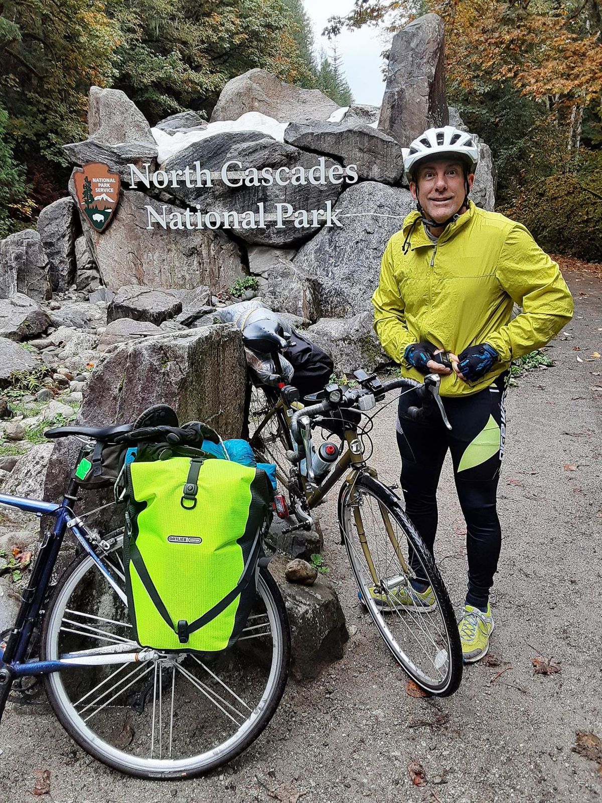
After 62 miles, we arrived in Marblemount, Washington. It’s not really a town, just a place before you get to North Cascades National Park where the Cascade River joins the Skagit River. There are a couple of gas stations, some park service employee housing, an RV park and a cheap $10 campground. We opted for the cheap campground. Everything was wet and there were large puddles on the dirt road through the campsites.
“We’ve had three days of nonstop rain,” said the campground owner collecting his fee. “Most people are here for the fishing. The pinks are running.”
After we set up our tent, we walked over to the nearby Cascade River and watched about a dozen anglers casting for salmon. A boy wearing basketball shorts and standing knee-deep in the water was giggling as he began reeling in a fish, then lost it. Nearby a man landed a large salmon.
I asked Chris how he was holding up. He had trouble getting into shape for the ride with life’s obligations and a last-minute appendectomy.
“That was rough,” he said of the day’s ride. “My butt is sore.”
I told him the next day was the real test – 5,000 feet of gain over Washington Pass.
Hills and climbs that would normally pose a minor challenge for cyclists take on a different force when you’re hauling an extra 30-plus pounds stuffed in bulky panniers.
The next day, about a third of the way up the pass, we stopped at the Ross Lake overlook in the national park for lunch. Chris was complaining about a sore leg and said he doubted he could make it.
“I’ll get us a lift,” I said confidently. I went begging. I asked people with trucks or trailers if they were headed east. Most people just wanted us to go away. A cyclist in a Toyota minivan overheard us and gave us a lift to the top of the pass, jamming our bikes into his vehicle.
“I rode this pass last year with my family all the way to the East Coast,” he said. “It’s brutal. My son took my panniers on his bike to help me out.”
From the top of the pass, Chris and I blasted downhill to the town of Winthrop, still another 30 miles away. We stayed the night in a KOA-style campground and woke to tame deer near our tent and 38-degree temps.
Chris was only planning to ride with me one more day to the town of Omak. But he would first have to get over Loup Loup Pass, a little better than 2,000 feet of elevation gain. With the help of plenty of rest stops, ibuprofen and snack bars we crested the top. Going down the other side was a breeze.
After 45 miles, I dropped Chris off at the Walmart in Omak (we had left his car there three days earlier), and I continued another 25 miles to the town of Tonasket. Some locals made fun of how I pronounced it. It rhymes with basket.
Behind the town’s visitor center in an area the size of a large carport, there’s a tiny sign that reads, “This camp area is for Traveling bicyclists only!” The nearby restroom was closed “Due to COVID-19.” I was stoked that it was free camping. The only amenities I could take advantage of were a cement picnic table and a grass lawn.
The next day would be my most brutal. Only 60 miles, but about 6,000 feet of elevation gain. I had two passes to climb: Wauconda and Sherman . Between the two passes, I refueled at the town of Republic (population about 1,100).
Sherman Pass was relentless. I told myself it was basically the same as doing three Sunnyside Hills back-to-back up to the landfill east of Ammon. When I finally crested the top, it was cold and I just wanted to find the campground that my map said was thereabouts. I started going down and passed a picnic area sign, but no campground signs. After a couple of miles, I gave up on finding the campground and instead pulled off onto a Forest Service road, found a flat spot and camped.
My camping setup consists of a tiny, one-man tent, air mattress, sleeping bag and ear plugs. Ear plugs do wonders for a good night’s sleep, muting forest sounds and noisy road traffic. For breakfast, I tried a freeze-dried biscuits-and-gravy mess that left me wanting the real thing.
From the top of Sherman Pass to the town of Kettle Falls is about 4,000 feet of downhill. Early in the morning at 25 to 30 mph, my toes were screaming about the cold. Despite the sunshine, I couldn’t take any layers off.
In Kettle Falls, I had cell service and called a “Bicycle Hostel” listed on my Adventure Cycling Association map. I was dreaming of a hot shower. The woman who answered said they didn’t expect any more bikers after Oct. 1, so they turned it over to a “homeless guy who is kind of messy.” After checking with the homeless guy, she texted me that it would be OK if I stayed the night. But she didn’t text me the key code to enter the building until after I had ridden out of cell service. I waited at the locked door for two hours before giving up and riding on. The hot shower would have to wait.
I rode for another dozen mostly uphill miles when the sun set and I needed a campsite. It came in the form of a pullout alongside the road announcing a view of Crystal Falls. I looked down the slope leading to the falls and saw a picnic table. I set up my tent just behind the table, ate some soup and tucked in just as it got dark.
The next morning was frosty and I had decided that I would find a motel in Newport, about 40 miles away, and warm up. After Crystal Falls, the road is “mostly” flat as you pass Lake Pend Oreille and follow the Pend Oreille River into Newport. After about 45-plus miles, I arrived in the busy crossroads town of Newport (population about 2,100). I found an overpriced, well-used motel, turned up the heater and took a hot shower, then walked about a mile to a nice Mexican restaurant and stuffed myself.
When I returned to the motel, I took a hot bath. The next morning, I took another hot bath and put on several layers to brave the frosty ride to Post Falls. My sweetheart, Julie, was to meet me there at noon.
I almost called her to say I’d be there early, but I’m glad I didn’t.
After two flats, and miles of road construction, I pulled into Post Falls right at noon. Total mileage about 430.