Seattle mapmaker celebrates 50 years of guiding hikers
SEATTLE – Has a paper map ever saved your skin?
Giddy with the view across central Oregon and suddenly reconnected to cell service, I frittered away my smartphone battery during a solo climb on Mount Jefferson in October 2019. By the time I was bushwhacking down the mountain below the tree line, my phone died. I was alone in unfamiliar terrain, but fortunately, I had bought a map of the area at a ranger station. Using the map and my watch’s altimeter, I found my way to the Pacific Crest Trail and hiked out relieved.
There are countless similar stories of backcountry mishap, which is why navigation is first on the list of the Ten Essentials, the 10 items you should carry into the mountains. Despite the advent of GPS-based digital navigation tools, which have earned the imprimatur of old-school outing clubs like the Mountaineers, the hard-copy map remains an invaluable asset.
Washington hikers who rely on maps have likely unfolded one from Green Trails Maps. Even casual hikers have probably seen one of these green-and-white numbers on the trail or at REI. The Seattle-based cartography company turns 50 this year, providing proof as clear as the compass rose that the hard-copy map is not going the way of the phone book.
While many print products have struggled in the face of digital competition, Green Trails is a thriving business that publishes the most reliable maps for the Cascades and Olympics. It retains a firm foothold through a combination of natural advantage in a backcountry setting, talented cartographers and boots-on-the-ground eyewitness confirmation.
Even as its business grows to chart trails beyond the Northwest, Green Trails has stayed committed to its local roots in printing, publishing, distribution and retail.
Maps made for hikers
It took a taskmaster to oversee projects as complex as the Boeing 747 and lunar lander. Walt Locke was a project manager who oversaw scheduling charts for some of the aerospace giant’s biggest efforts. He was also an avid hiker with a vendetta against U.S. Geological Survey topographic maps – government-issued maps helpful for assessing mining claims or logging opportunities that were not designed with the trail hiker in mind. (USGS maps are still popular for off-trail alpine climbing and scrambling routes.)
In 1973, Locke started Green Trails Maps and began reworking USGS maps of Washington’s mountains into something more hiker-friendly. In the field, he worked with basic tools like a wheel odometer, compass and altimeter to confirm the distances and routes of trails that he then translated into paper maps as a self-taught cartographer.
Locke was responsible for some of the signature features that make Green Trails among the best trail maps in the business: bright, bold color choices (predominantly green for trails) and easy-to-read typefaces. For trip planning, Green Trails Maps include helpful touches like information on the length between two trail junctures and the altitude at each juncture, so you don’t have to squint at topo lines to figure out the elevation change along a given trail segment. You’d never find that on a government map.
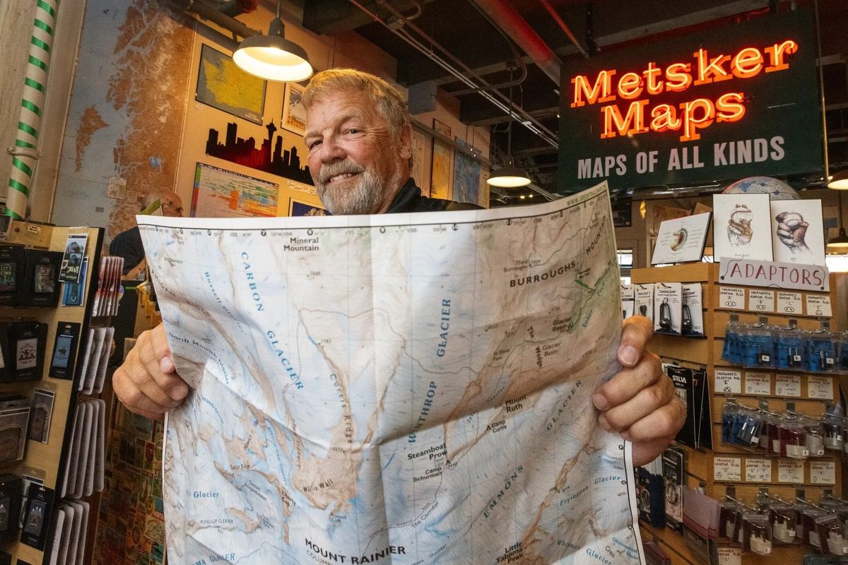
“It gives you the big picture of getting to your destination, seeing what the trail looks like or what is beyond your current destination – like a lake just beyond the peak,” said Skip Ross, manager and co-owner of Seattle’s Metsker Maps, the first store to carry Green Trails. “Looking at a map visually rather than a little screen gives you a bigger picture.”
Green Trails maps are also prized for their accuracy. On a July weekday, part-time trail researcher Matt Speten set off from Rattlesnake Lake along the Snoqualmie Valley Trail to check out a piece of land shared by King County and Camp Waskowitz, putting in legwork for a map he’s working on of Rattlesnake Mountain and its environs. There were user-generated reports of public trails on apps like AllTrails, but it’s Green Trails’ policy to vet trails in person before potentially including them in their maps.
Such rigor is part of the appeal for Speten, an environmental scientist who relishes his side hustle: getting paid to hike.
“I grew up looking at maps,” he said. “Whenever I found an error, I got annoyed.”
That stickler mentality is ideal for a Green Trails researcher, as the company insists on regular revisions of even the most pedestrian trail maps.
Rattlesnake Ledge sees so much traffic that it might as well garner a state highway number; getting truly lost would be difficult given the all-day crowds. But the extremely popular route underwent trail work that wrapped up in spring 2022. Whether it’s a new bench, staircase or information sign, the latest Green Trails Map for Rattlesnake Mountain will include the update.
The map business
A jaunt down the Snoqualmie Valley Trail is an easy afternoon’s work, but high-endurance trail runners based in Washington, like Craig Romano, Tami Asars and Wendy Wheeler Jacobs, will sometimes tick off 20-30 miles a day while trail vetting for Green Trails. They feed this information to a small but dedicated coterie of cartographers, some of whom have been contracting with Green Trails for decades, to update old maps and prepare new ones from scratch.
They have a lot of trail to cover – Green Trails sells 70,000 copies annually from its library of 161 maps. Today, Green Trails can help you navigate well beyond Washington, with maps covering parts of Arizona, California, Oregon, Nevada and Utah.
Green Trails has eight new titles planned for spring 2024. New maps are driven by sophisticated research: a digital heat map of trail usage throughout the West to see which areas are most popular among hikers. That analysis has put the Sierra Nevadas, Idaho and more of Utah and Arizona on the company’s radar.
“We are very viable and we are growing,” said company President Alan Coburn, who took the reins in 1993.
Coburn met Locke in the early 1970s when they worked at an engineering firm. The two developed a big brother-little brother relationship. Coburn was also an avid hiker, and began staffing sales routes on behalf of his older friend when Locke suffered a stroke. By the early 1990s, the Lockes were ready to sell the company and its stable of approximately 100 maps.
“Green Trails had been selling well, but when Walt had his stroke, it stalled,” Coburn said. “Nobody would take over the printing, no one had technical expertise. It was successful but not sustainable.”
Coburn and his equally outdoorsy wife, Gail, affectionately known as Mama Llama for her work hauling the couple’s kids along on backpacking trips, took over in 1993. Locke died soon after.
Coburn steered the company to newer, higher-margin products. Whereas USGS maps started and ended according to latitude and longitude, Coburn encouraged his cartographers to center a map in order to accommodate the most number of trails a hiker would likely consider in a given area, like Snoqualmie Pass.
Coburn saw Green Trails as a key role player in Washington’s outdoors community. Shortly after he took custody of the company, a then-modest Washington Trails Association asked if the mapmakers would become corporate sponsors of the trails nonprofit, which was just beginning to tackle trail maintenance projects. Coburn agreed, writing a $2,000 check. Years later, he learned that donation might have saved the trails organization from going kaput – until the check cleared, WTA had $3.67 in its bank account. Today, it’s a powerhouse.
Coburn also helmed the company through its biggest challenge: the advent of digital navigation tools.
When the likes of Gaia GPS, AllTrails and CalTopo came on the scene around 2010, Coburn said Green Trails “saw it as a threat.” The company joined the app bandwagon, but hundreds of thousands of dollars in investment yielded only thousands in revenue. Coburn pulled the plug on the app by the mid-2010s. Green Trails realized that software is essential in design, but the end product should be a map, not an app.
Static digital versions of Green Trails are available for sale via the Avenza app.
While plenty of hikers swear by their preferred digital navigation option, Coburn makes a strong case that the hard-copy map offers something its digital counterparts will never match.
“Your devices aren’t big enough to show you the context at any level of detail that from our point of view would be useful,” he said, citing the possibility of needing to find an escape route in a wildfire. “If you unfold a map, you can see where you are and get a better handle on where you can go.”
Coburn’s stewardship also resulted in the durable quality of today’s Green Trails maps. Made of Polyart tearproof synthetic paper, with special ink to shade topographic relief, and printed at Capitol City Press in Olympia, these maps have a clear selling point: waterproof, solar-powered, no batteries required.
In 2019, Seattle-based Mountaineers Books became Green Trails’ exclusive distributor, a partnership that provided stability and ensured longevity for the mapping enterprise as the company’s second owner enters the twilight of his career.
An established national distributor is a far cry from Green Trails’ scrappy early days. Locke used to deliver copies himself to Metsker Maps, then in Pioneer Square, which remains Green Trails’ oldest retailer. From today’s Pike Place Market location on First Avenue, adventurous visitors continue to buy Green Trails maps before heading into the mountains. The Wonderland Trail map in Mount Rainier National Park is the No. 1 seller, with the Enchantments a close second. (Wonderland is Green Trails’ best all-time seller.)
You can also get Green Trails Maps from most outdoor gear shops in the Seattle area as well as online at mountaineers.org/books.
“Most people go to bed with a good book,” said Seattle resident Gwen Tollefson, a former volunteer wilderness ranger . “I go to bed with a good map, and Green Trails have long set the standard for the trail maps industry.”